ArcGIS Online lets you understand the world around you by using interactive maps to connect people, locations, and data. You get smart, data-driven styles and intuitive analysis tools that deliver location intelligence. ArcGIS Online gives you the ability to make maps and apps to share your insights with your organization or the world. You can use it as a complete, cloud-based solution or to extend and complement the capabilities of ArcGIS Pro and ArcGIS Enterprise.
Don’t have an ArcGIS account? See Create an ArcGIS Account.
The June 2022 update includes new functionality in Map Viewer plus other enhancements and new capabilities throughout the ArcGIS Online website. Highlights are provided below.
Quick links
Use the links below to jump to sections of interest.
- Feature layer previews
- Map Viewer
- Scene Viewer
- ArcGIS Instant Apps
- ArcGIS Dashboards
- ArcGIS Experience Builder
- Data management
- ArcGIS Notebooks
- Accounts and administration
- Content

Feature layer previews
A feature layer is a grouping of similar geographic features, for example, buildings, parcels, cities, roads, and store locations. Features can be points, lines, or polygons (areas), and may also have tables associated with them. Feature layers are published in two ways: hosted feature layers are layers that have been published to ArcGIS Online, ArcGIS Enterprise referenced feature layers have been published from your own ArcGIS Server.
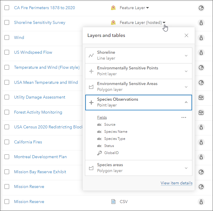
It is now easier to discover, explore, and work with feature layer items in ArcGIS Online. When browsing content listings, you can quickly preview a feature layer’s sublayers and tables and see a list of associated fields. The preview window also offers options for working with the sublayers and tables contained in a feature layer, such as viewing details about the item or opening it in Map Viewer.
Feature layer search
When you search for items, ArcGIS Online now finds the sublayers and tables inside feature layer items that match the search keywords you enter. This helps reveal sublayers and tables in search results that were previously unavailable because they were hidden inside the feature layer items.
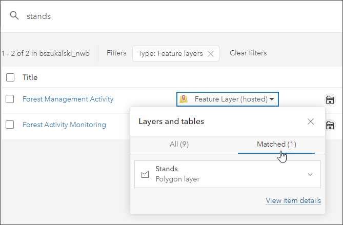
The matching sublayers are shown in the preview.
For more information, see Introducing feature layer previews and Browse and search content.

Map Viewer
With this update, Map Viewer has been enhanced with new capabilities and features, including the following:
Chart styles
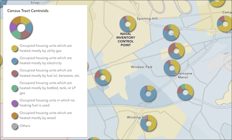
Two new smart mapping styles in Map Viewer allow you to visualize categorical numeric data as a pie chart. Use the Charts style to compare categories in a single feature and the Charts and Size style to compare categories in a single feature and the totals between locations.
Pie chart symbols can help answer questions such as what the proportions of categories are for each feature on a map, or comparing counts or other summary statistics between locations. Use the chart slider to set the chart to Pie or Donut. The closer the handle is to Donut, the larger the hole in the center of the chart.
Heat Map style improvements
Heat maps are useful for displaying point datasets with large numbers of features that are close together or overlapping. A heat map displays the relative density of points on the map as varying sets of colors ranging from cool (low density of points) to hot (high density of points).
The Heat Map style has been improved to support faster and smoother effects. In addition, heat maps now support filtering, labels, and pop-ups. Filtered feature effects can also now be applied to emphasize areas that meet a certain criteria. For example, the map shown below uses a heat map showing home sales in Chicago, Illinois, and uses a filtered effect to emphasize home sales over $1 million dollars.
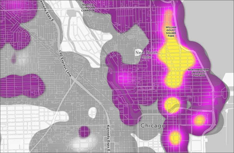
The heat map can also be locked to prevent regeneration at each zoom level. For more information, see the Heat Map style documentation.
Chart colors
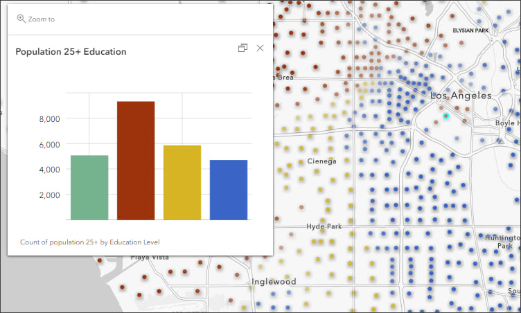
Charts in pop-ups provide a visual and meaningful way to display numeric attribute information. You can add pie charts, bar charts, column charts, and line charts. When using styles rendered using multiple attributes, chart element colors in pop-ups now automatically match the style colors.
Multilayer vector symbols
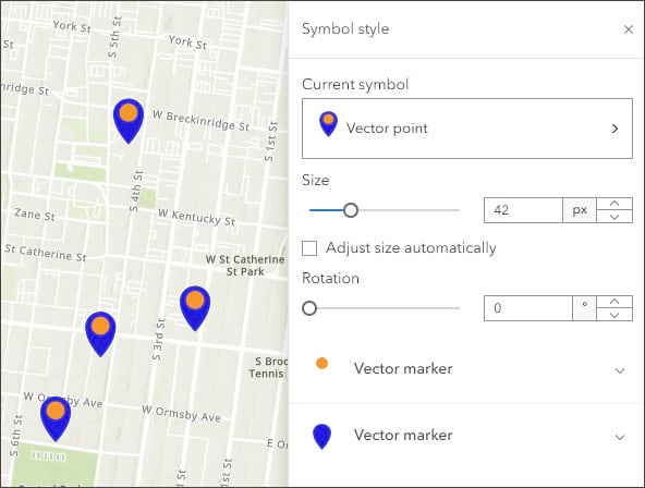
You can now visualize and customize multilayer vector symbols for points, lines, and polygons in Map Viewer using symbol layers. Symbol layers allow you to style each component of a multilayer symbol independently. Map Viewer also supports complex polygon fills including hatch fills made from marker symbols that can be distributed randomly or uniformly and with varying degrees of density. Multilayer vector symbols can be used when styling a layer or creating a sketch layer.
Save layers and tables
Map Viewer now supports saving feature layers and table layers as items in My Content. This allows you to preserve your layer or table configurations for reuse in other maps.
- Save: Saves changes to an existing layer or table item. This option is available when you own the item or have privileges to edit it. For layers, this is the equivalent of Save Layer in Map Viewer Classic.
- Save as: Creates a new item in My Content from a layer or table in the map. The new item stores the current layer or table properties as configured in the map, and becomes the source for the layer or table in the map.
You can also save, configure, and apply effects to route layers, as well as recalculate the route and open the directions pane from the pop-up.
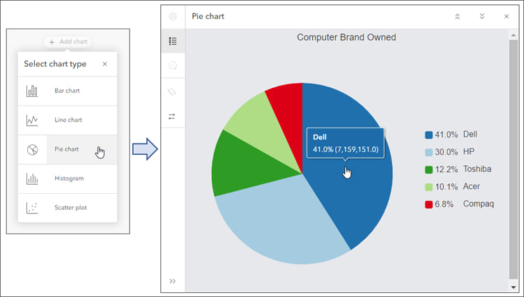
Configure pie charts
In Map Viewer, you can create one or more charts from a feature layer or table in a map. Select the layer or table in the Layers pane, which is accessed from the Layers button on the Contents (dark) toolbar. Then on the Settings (light) toolbar, click Configure charts.
With this update, pie charts can now be added and configured, joining bar charts, line charts, histograms, and scatter plots.
Upgrade from Map Viewer Classic to Map Viewer
Organizations created before April 2021 which have never upgraded from Map Viewer Classic to Map Viewer are now upgraded to Map Viewer. Organization administrators may change the organization’s primary map viewer back to Map Viewer Classic via their organization settings.
For more information, see What’s new in Map Viewer (June 2022).

Scene Viewer
Use Scene Viewer in ArcGIS Online for creating, viewing, and exploring 3D scenes. With this update, Scene Viewer has been enhanced with new capabilities and features, including the following:
Weather effects
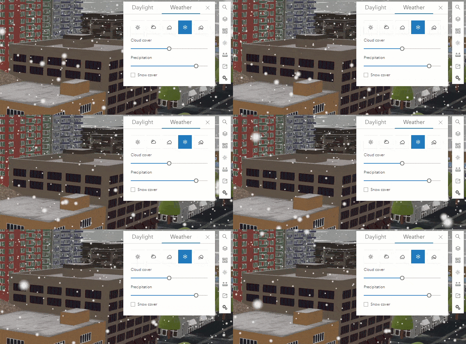
You can enhance your scene visualizations by adding weather effects such as clouds, rain, snow, and fog using the new Weather tool. The weather settings are also captured in scene slides for playback and sharing. Weather effects complement sunlight effects you can add using the Daylight tool.
OpenStreetMap 3D layers
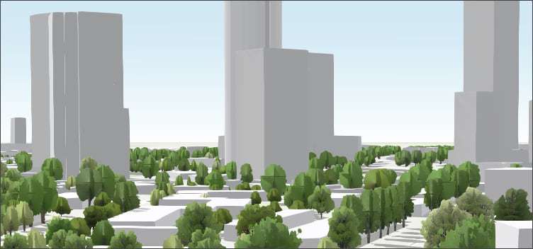
Scene Viewer now allows you to add 3D buildings and trees (both thematic or realistic) to your scene that are globally available from the OpenStreetMap Daylight Distribution via ArcGIS Living Atlas. You can mask out areas where you want to show 3D data of your own. For more information, see the Content section below.
360 VR Experiences
You can now create immersive 360 VR experiences directly from existing web scenes in addition to using the ArcGIS 360 VR web application. The creation process transforms a scene into a 360 VR Experience and publishes it to ArcGIS Online. Each Scene Viewer slide is converted to a viewpoint in the resulting 360 VR Experience. See the ArcGIS 360 VR gallery for examples.
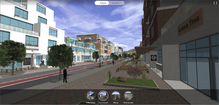
Other enhancements and additions
- Scene Viewer now supports GeoJSON and CSV layers in your scenes.
- Perform line of sight analysis and save it in your slides to share with others.
- Styling in Scene Viewer has been enhanced. You can style your line data with different patterns or add markers, such as arrows, to show direction in your scene. You can also view heat map visualizations of point layers.
- You can now use the Daylight tool to improve lighting in your scene, such as in the polar regions.
- The editing experience in Scene Viewer has been improved with ToolTips that guide you while creating and editing features.
For more information, see What’s new in Scene Viewer (June 2022).

ArcGIS Instant Apps
ArcGIS Instant Apps is the latest generation of configurable apps, featuring a streamlined experience that lets you build apps quickly and easily using express setup mode, or you can switch to full setup mode to select additional tools and settings. All Instant Apps templates are available via a searchable gallery that can be opened in several ways:
- From the Overview tab for a map or scene item, click Create Web App and choose Instant Apps.
- From Content, click Create app then choose Instant Apps.
- From the app launcher.
- Using Map Viewer, click Create app in the Contents (dark) toolbar, then choose Instant Apps.
- Using Scene Viewer, click Create app in the Designer toolbar, then choose Instant Apps.
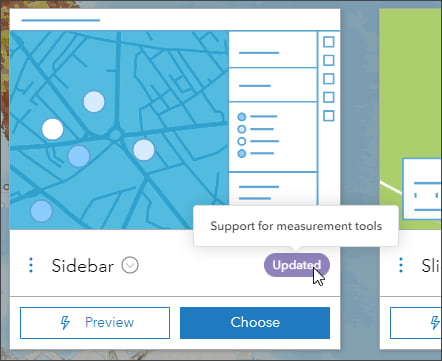
Hover over the New and Updated badges in the gallery to learn more about new or updated app templates.
A new Suggestions pane in the Instant Apps gallery lets you answer questions about capabilities you are looking for and presents the apps that best match your answers.
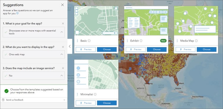
ArcGIS Instant Apps includes several overall updates plus specific updates to several apps.
Updates to all Instant Apps templates
The Share button now captures the current appearance of the app, such as the map extent, visible layers, and opened pop-ups.
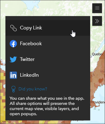
Other updates include more theme settings to change the font, colors, and logo and the option to use Adobe Analytics for tracking app usage. For more information, see Add web analytics to ArcGIS Instant Apps.
Template updates
Exhibit allows authors to tell a linear, interactive story with a single map. Viewers can move through slides defined by the author to gain new information about the map and its data. Layer visibility can be changed and new basemaps can be chosen for each slide to present information in different ways. Exhibit now supports web scenes and time-aware bookmarks.
Chart Viewer allows viewers to explore your map beside charts related to your data. Up to ten charts can be included and each can be viewed alongside your map or side by side with other charts for comparison. Chart Viewer adds support for pie charts and the ability to zoom in and view the full extent.
Countdown provides an ordered collection of map locations that viewers can navigate. The locations can be ordered by values from any field. Countdown now includes a play button to let app users cycle through all lists in the app.
Portfolio is a good choice when you want to showcase a collection of content, or different types of content all in one app. You can choose different presentation options such as carousel, tabbed or accordion layouts. Portfolio now offers multiple sizes for the accordion layout and a new mobile design.
Sidebar includes a set of tools and options that appear alongside the map that allow viewers to interact with and update data. Sidebar now adds support for measurement tools.
For more information, see What’s new in Instant Apps and What’s new in Instant Apps (June 2022).

ArcGIS Dashboards
ArcGIS Dashboards enables users to convey information by presenting location-based analytics using intuitive and interactive data visualizations. Dashboards are used to help make decisions, visualize trends, monitor status in real time, and inform their communities.
With the June 2022 update, ArcGIS Dashboards includes additional map action support. Elements with categories based on grouped values now support pan, zoom, and flash actions. For more information, see What’s new in ArcGIS Dashboards.
Note that ArcGIS Dashboards Classic is currently in mature support and will be retired. Authors should upgrade from ArcGIS Dashboards Classic to ArcGIS Dashboards. For more information, see Prepare for the retirement of ArcGIS Dashboards Classic.

ArcGIS Experience Builder
Use ArcGIS Experience Builder to build modern mapcentric or non-mapcentric web apps and webpages without writing any code. Engage your audience through compelling web experiences on any screen size. Start from scratch or choose from an extensive library of templates that you can easily customize. Add advanced functionality with widgets you can drag, drop, and configure. Enjoy fully flexible layout options to build any web experience for any purpose.
Three new widgets are available in ArcGIS Experience Builder.
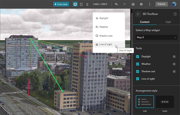
The 3D Toolbox widget adds 3D effects and analysis tools to both global and local web scenes. The widget supports daylight, weather, shadow cast, and line of sight tools. The tools can be styled as either a list or collection of icons, and can be arranged horizontally or vertically.
For more information, see 3D Toolbox widget.
The Print widget allows you to print web maps with options such as previewing the print extent and choosing the print layout.
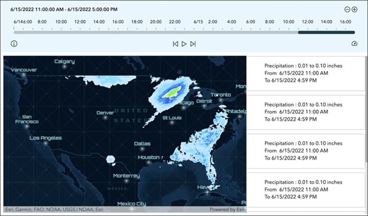
The Timeline widget allows you to view temporal data from web maps, feature layers, and map service layers to see how data changes over time. Using this widget, you can animate data with play and pause buttons, manually view changes using a time slider, and zoom in and out on a timeline.
For more information, see Timeline widget.
Other enhancements include support for resetting the Filter widget to its default settings. For more information, see What’s new in Experience Builder.

Data management
As the owner of a hosted feature layer view, you can now update the view to reference a different source layer. This allows you to continue using the existing view when you need to update the source layer and is useful if you have the same source data, but the attribute values have changed.
You can export features from a hosted feature layer to an Open Geospatial Consortium (OGC) GeoPackage file if the feature layer is configured to allow data exports. You can also publish a hosted feature layer from the contents of an OGC GeoPackage file.
The Replace Layer option allows you to replace the content of the current hosted raster tile layer with the content in a replacement layer. The content from the current layer is archived.

ArcGIS Notebooks
ArcGIS Notebooks provide a versatile web-based interface for powerful geospatial data analysis. With notebooks, you can perform analysis, automate workflows, and immediately visualize data and analysis results in a geographic context.
You can now insert code snippets directly into your notebooks in ArcGIS Notebooks. Code snippets are reusable, prewritten code that allow you to quickly implement common administration, content management, and analysis workflows in notebooks.

Administration
Organize members using categories
ArcGIS Online organizations can set up hierarchical categories for organizing members according to characteristics such as department, location, and expertise. Administrators can use these member categories to filter the list of members when performing member management tasks. Learn more about member categories. Administrators can now assign member categories when inviting or adding new members to the organization. Member categories make it easier to find and manage members in the organization.
Administrative reports
Administrative reports have been improved. Service usage reports are now available for all organization types. Administrators can also create activity, credit, and service usage reports that cover the previous quarter, and set a quarterly cadence for scheduled reports. Other improvements include the ability to change the ownership of report schedules and new Member Categories and Verified Email Status fields in the member report.
Security
A new security setting allows organizations to prompt all members with unverified email addresses to verify their addresses when signing in. Administrators can also see a list of unverified members and confirm and edit members’ email addresses as needed. Verifying that email addresses are valid helps ArcGIS Online users and administrators receive critical information from ArcGIS Online, such as password resets and account changes. For more information, see Verifying your email address in ArcGIS Online.

Content
ArcGIS Living Atlas of the World is the foremost collection of geographic information from around the globe. It includes curated maps, apps, data layers, and tools from Esri and the global GIS user community that support your work.
The following are new content additions of general interest to ArcGIS Online users, specifically those working with scenes.
OpenStreetMap 3D buildings and tree layers (Beta)
OpenStreetMap (OSM) is a collaborative project to create free editable geographic data of the world. Three new 3D scene layers based on OSM data and hosted by Esri are now available via ArcGIS Living Atlas. All layers are based on the latest OpenStreetMap (OSM) Daylight map distribution and are updated each month. Buildings and trees include pop-up information which displays the tags and links to view and edit features in OpenStreetMap.
The following 3D layers are now available:
OpenStreetMap 3D Buildings is a scene layer created by Esri from the OSM Daylight map distribution buildings data. The buildings are rendered using information found in the OSM tags for each feature, including height and levels.
OpenStreetMap 3D Trees (Thematic) presents OSM trees as a 3D scene layer rendered using a thematic representation of the trees from the Esri tree symbol library. The closest matching tree type is determined from the OSM tree type tags.
OpenStreetMap 3D Trees (Realistic) presents OSM trees as a 3D scene layer rendered using more detailed tree symbols representing specific species from the Esri tree symbol library. The closest matching tree type is determined from the OSM tree type tags.
For more information, see the OpenStreetMap 3D Scene Layers documentation and New OSM 3D scene layers.
For more information about ArcGIS Living Atlas, visit the ArcGIS Living Atlas website, view Living Atlas blog articles, or browse for items you can use.

More information
For more information and additional details about this release, see the What’s new help topic or view all posts related to this release. You can also watch a video demo to see the new capabilities in action.
For other information, see the ArcGIS Online blog articles and ArcGIS Online at the Esri Community.
For news, updates, and information about other products, see the ArcGIS Blog and product resources at the Esri Community.

Commenting is not enabled for this article.