
The Esri International Infrastructure Management & GIS (International IMGIS) conference is coming up on April 9-11 at the Kap Europa Center in Frankfurt, Germany. This event, targeted at architecture, engineering, and construction (AEC); electric, gas, and pipeline; telecommunications; transportation; and water agencies, is a great opportunity to explore the geography-driven power of ArcGIS and how it is shaping the future of infrastructure and smart communities. In this blog, we will explore:
Indoor GIS Patterns of Use: An Infrastructure Management Perspective
Indoor GIS is a unified floor-aware ArcGIS system for visualizing, analyzing, and managing indoor spaces. This capability enables organizations to make their operations and maintenance activities more efficient and ensures a better experience for the occupants and visitors of their buildings. Indoor GIS is powered by indoor maps created with ArcGIS Indoors, and indoor positioning could be overlaid through ArcGIS IPS.
Before diving into the details of the conference, lets remember the patterns of use for indoor GIS as it relates to infrastructure lifecycle management.
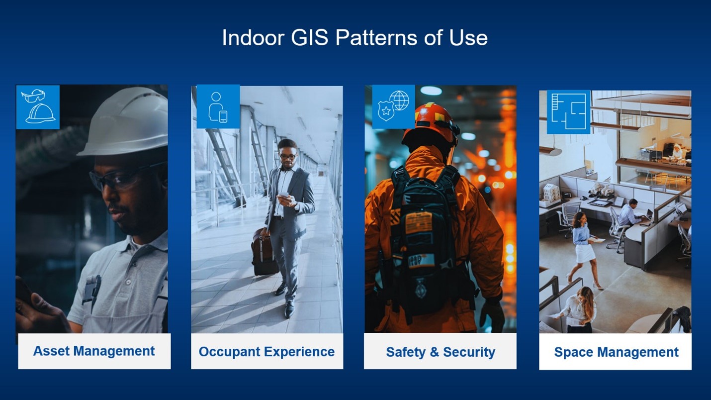
Asset Management: Asset management is a critical application of indoor GIS technology, particularly for accurate asset mapping that enables efficient management of service or work orders for inspection, maintenance and repairs, and real-time location awareness and indoor positioning.
Safety and Security: Safety and security are mission-critical needs for many organizations and indoor GIS capabilities can enable improved situational awareness and emergency response by quickly identifying locations of personnel, evacuation routes, and exits. A couple of emerging trends in this area are tracking security personnel to dispatch the closest member and enhanced incident reporting using location intelligence.
Occupant and Visitor Experience: Indoor GIS enhances the visitor and employee experience through wayfinding and turn-by-turn navigation in complex facilities, as well as provides tools for workspace reservations. It also makes it easier to find people, places, assets, events, and work orders.
Space Management: Indoor GIS capabilities provide organizations with a comprehensive overview of facility usage, making it easier to improve space usage as needed. For instance, you can consolidate unused space or re-assign it to a different business unit, thereby improving space usage.
By focusing on these four pillars—asset management, safety and security, occupant and visitor experience, and space management—organizations can leverage indoor GIS technology to achieve greater operational efficiency, improve safety, and enhance occupant experience. We look forward to exploring these topics further and discussing with you how indoor GIS can benefit your specific needs and challenges. Be sure to find us at the International IMGIS.
Frankfurt Train Station Demos
Back by popular demand! The Frankfurt Main Station is equipped with an indoor positioning system and an indoor map. During this field trip, we will demonstrate live positioning and navigation on multiple levels of the station, from the platform to the shopping to the underground S span levels. We will also discuss the different indoor positioning methods and show how to deploy and manage beacons for real-time indoor positioning and how to set up indoor maps for complex environments like Frankfurt Main Station. These demonstrations will help attendees understand the practical applications of indoor GIS and how it can be integrated into their own facilities.
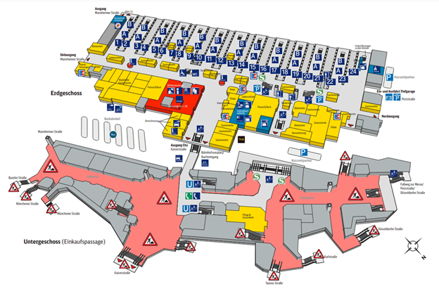
Below are the timings.
- Wednesday, Apr 9 | 14:15 – 15:00 CEST
- Thursday, Apr 10 | 13:30 – 14:15 CEST
Registration is limited for this event. Please email confregis@esri.com to secure a spot.
Sessions
Attended focused sessions highlighting real-world successes and the latest capabilities in Indoor GIS.
Indoor & Building Management Part 1: Insights for Better Planning
User Presentation | Wednesday, Apr 9 | 15:00 – 16:00 CEST | Mistral | Kap Europa
Discover how GIS enables better buildings that positively impact people, profit and planet through Indoor GIS and space management. People spend 80–90% of their time indoors, where buildings shape experiences, communities, and landscapes. This session showcases how to use Esri software to capture, analyze, and share spatial insights, enabling better space planning and indoor visualizations.
Indoor & Building Management Part 2: Using ArcGIS Indoors to Optimize your Data
Esri Technical Session | Wednesday, Apr 9 | 16:30 – 17:30 CEST | Mistral | Kap Europa
An Indoors GIS System is combining the full power of ArcGIS-Technology to create the right environment to your business system. Let’s take a closer look on Indoor GIS and how it can positively affect your everyday life by simply using the same Data as usual only this time indoors.
Facilities and Vertical Asset Management for Water and Wastewater
Esri Technical Session | Friday, Apr 11 | 09:00 – 10:00 CEST | Meridian 1-2 | Kap Europa
In this session, we will review of examples of what water and sewer utilities are doing today to build GIS into their treatment plants and other important structures. We will also explore ways utilities can manage their facilities and vertical assets with and without ArcGIS Indoors.
Reality Mapping and 3D Point Clouds: Inside and Out
Esri Technical Session | Friday, Apr 11 | 09:00 – 10:00 CEST | Mistral | Kap Europa
Explores how Reality Mapping technologies with indoor mapping solutions can create comprehensive, location-aware environments combining high-precision outdoor reality mapping with indoor technologies, such as LiDAR, 360 imagery, IoT sensors, and floor plans, enables accurate spatial understanding across entire infrastructures. Also learn how Point Clouds be visualized and analyzed in ArcGIS Pro showing the entire workflow from loading a dataset, visualization, classification, feature extraction, conversion and how you can publish and share your point cloud using ArcGIS Online.
Esri Showcase
Get personalized guidance from Esri experts for your Indoor GIS needs. At the Esri showcase, we will demonstrate the latest tools in ArcGIS Indoors and ArcGIS IPS and discuss the other floor-aware ArcGIS products such as ArcGIS Field Maps, ArcGIS Experience Builder, ArcGIS Maps SDKs, ArcGIS QuickCapture, ArcGIS Survey123, and ArcGIS Mission.

Resources
Explore Indoor GIS resources to stay up-to-date on the latest information.
The Esri International Infrastructure Management & GIS Conference 2025 is a must-attend event for anyone involved in the management of complex indoor environments. Whether you are a facility manager, a GIS specialist, or a technology innovator, this conference will provide you with the knowledge, tools, and connections needed to stay ahead in the dynamic field of Indoor GIS.
See you there!

Article Discussion: