ArcGIS Web Editor is available now. It is included in the June 2024 update to ArcGIS Online and coming soon to ArcGIS Enterprise 11.3 (Sept 2024). Watch the 2 minute overview video here.
Web Editor’s goal is to make GIS data editing easy for you and your team members. For ArcGIS Pro users, Web Editor can supplement editing workflows. With it, GIS professionals can empower others to do their own data editing work themselves, instead of doing the editing work for them. Web Editor enforces data rules when data is captured, so less QA work is needed.
Likely in the past, you’ve had a coworker ask you to update their GIS data. If you’re lucky, they asked you for an app to update the data themselves. Think back – what was their success of using that data editing app? Consider digging up these old requests, it’s time to revisit your strategy of self-service GIS data maintenance!
Introduction to the App Layout
The Web Editor layout may seem reminiscent of Map Viewer, and this is no coincidence. ArcGIS Web Editor delivers efficiency through familiarity and simplicity. It is 100% centered on the editing experience. The name “Web Editor” says it all – data editing is the focus, it’s not a secondary activity. For example: the pan tool is enabled by default to begin working right away.
The image below describes the overall layout of ArcGIS Web Editor.
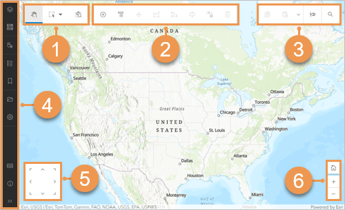
- Selection pane is in the top left.
- Editing toolbar contains tools to create and modify features.
- General toolbar has options for copy and paste, snapping, and searching.
- Contents toolbar (in dark) is used to manage key components of the map.
- Directional pad, or D-pad can be used to pan the map as you edit without interruption.
- Zoom tools focus the map in and out or return to the home extent.
Web Editor App Concepts
As you start working with Web Editor, notice how toolbars are contextual. When a selection is made, the tools and options are subset to reveal only those that are appropriate. This subset of tools may be driven by the type of feature (point, line, or polygon) selected, or it may be driven by the initial tool selected. The idea here is to quickly expose only those things that are relevant to the task at hand.
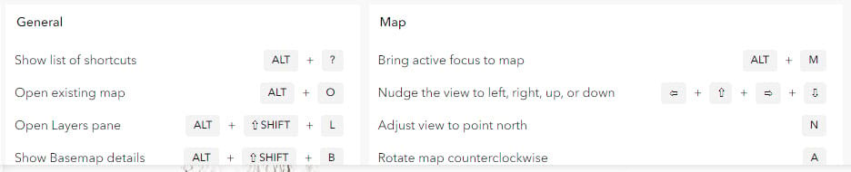
Over time, as an editor becomes comfortable with the application, they will likely be repeating clicks and steps, over and over. Repetition is part of the data editing job. To help with this monotonous work, Web Editor has a full set of over two dozen keyboard shortcuts. Keyboard shortcuts can enhance efficiency for data entry specialists, and you might find them useful as well.
The image below shows some of the keyboard shortcuts available.
Getting started just requires one thing – a web map containing editable data. As usual, the web map is configured and published within either Map Viewer or ArcGIS Pro. To fully leverage the benefits and value, the web map configuration will ideally contain a configuration of a form.
Capabilities and Functionality
In its first release, Web Editor offers a solid base set of GIS data editing tools. This beginning foundational launch sets the baseline for much more to come. Here’s a shortlist of what you’ll find included today:
- Selection management (interactive map tools and cumulative attribute queries)
- Geometry guides and editing constraints
- Interactive table view
- Edit tools (move, vertices, reshape, split, merge, copy and paste)
- Undo and redo (while sketching a geometry)
- Support for contingent values and attribute rules (authored outside of Web Editor)
- Snapping control (including rule-based snapping with Utility Networks)
- Some more advanced features are only supported through ArcGIS Enterprise (and not ArcGIS Online), such as Utility Network trace, validate, and working with branch versioned services.
- Support for group and preset templates (authored in ArcGIS Pro)
In addition to adding new functionality to ArcGIS, many major concepts are already in place within the ArcGIS system (for example forms and templates). Web Editor brings many pre-existing ArcGIS web tools into a well-designed single package and provides the dedicated space to fulfill these editing activities. As a result, you will notice consistency in this platform approach across all ArcGIS application experiences.
Selection
Editing tasks frequently start by finding the features and records that need to be updated. This selection can also be iterative, building up and managing your selection with map interaction and attribute queries. The Web Editor selection pane allows users to build multiple selection queries to identify the exact features you need to work with.
The below video shows how additive selection criteria can be easily defined.
Editing Tools
The editing toolbar contains the expected choices for creating and updating feature geometries. Some options include move, reshape, edit vertices, split, merge, copy and paste, delete, and more.
The below video shows some of the most used editing tools.
Drawing Tools
The editing toolbar also contains several choices for drawing features. The drawing tools work in synch continuously, so you don’t have to work with just one tool – they all work together. For example, a polygon may be constructed with the create features line tool, then right angle tool, and then the freehand tool.
The below video shows how multiple drawing tools can be used in combination.
How To Get Started
Anyone with a Creator user type or higher can use ArcGIS Web Editor. Open it from the app launcher, through the application URL, or by opening a web map containing editable data.
What’s Next
The capabilities outlined above, and more, are available now. Future updates will add highly requested capabilities such as bulk attribute editing, a trace and follow tool, and ability to save and share configurations. There’s lots more coming!
Over the coming months and beyond, we will be sharing more tips and tricks for working with this new product. To learn more about the coming advancements, bookmark the following:
- The documentation page, where you can learn how to get started and always see what’s new in the latest update.
- The Esri Community page, where questions are asked and answered, and new ideas posted directly to the product team.
- Lastly, the ArcGIS Web Editor product overview page gives an overall description of what this application is capable of.
With that… we strive for ArcGIS Web Editor to fulfill it’s potential within your workplace. The team has worked hard and relied on your feedback to help us build what you need. Web Editor helps make your GIS data maintenance experience as exceptional as possible. This includes scaling edits out to new users within your organization, reducing inaccurate data within your system, and streamlining processes to be more efficient. Give ArcGIS Web Editor a try and let us know what you think on the Esri Community page. More to come soon!


Commenting is no longer enabled for this article