In the United States, about one in every 128 drivers each year will collide with a wild animal, causing more than $8 billion in damages, according to the US Department of Transportation.
Safeguarding people and wildlife along transportation corridors is crucial, but it requires having precise information about wildlife crossing locations. This is why the Nebraska Game and Parks Commission, in collaboration with the Nebraska Department of Transportation (NDOT), joined forces with industry leader and Esri partner VECTRONIC Aerospace for an innovative wildlife study. The project team used VECTRONIC Aerospace’s solar-powered GPS collars in conjunction with ArcGIS Online and ArcGIS Velocity to create a real-time 3D monitoring system that tracked where bighorn sheep were—and weren’t—crossing roads.

Protecting Bighorn Sheep and Motorists
To help reduce vehicle collisions with wildlife, NDOT received a federal grant from the US Department of Transportation’s Federal Highway Administration to engage in construction and nonconstruction projects (such as fixing fencing) that would protect both motorists and wildlife. The funding is part of an initiative led by the US Department of the Interior to improve habitat quality and migration corridors for big game in Western states, especially in winter.
The grant enabled NDOT to conduct hot spot analyses of wildlife-vehicle collisions and engage in planning and research to aid wildlife management. It allowed the department to monitor wildlife movements and migrations relative to the location of renewable energy infrastructure, such as wind and solar farms. Additionally, it funded efforts to mitigate disease transmission between domesticated and wild animals.
The Nebraska Game and Parks Commission has been instrumental in bighorn sheep restoration efforts since 1981. The state has successfully returned Rocky Mountain bighorn sheep to the Wildcat Hills and Pine Ridge regions of western Nebraska. But the number of vehicle collisions with the animals grew. Between 2009 and 2023, most vehicle collisions in the state involving bighorn sheep occurred in the Wildcat Hills State Recreation Area along Nebraska Highway 71.
An initiative to expand the Heartland Expressway—which, in part, comprises Highway 71 and traverses Nebraska, linking Rapid City, South Dakota, to Denver, Colorado—was being planned. The area seemed to be a natural crossing for bighorn sheep, though. So NDOT and Nebraska Game and Parks began collaborating on a study about the dangers to bighorn sheep and motorists and the best ways to mitigate those hazards.
The study was designed to provide the comprehensive data needed to make informed decisions about the necessity, location, and costs of building wildlife crossing structures—such as underpass tunnels, viaducts, or overpasses—along with other potential mitigation strategies, according to Nebraska Game and Parks.

Quick Data Analysis Has a Range of Uses
For the team, it was crucial that the study pinpoint current wildlife crossing areas to guide the construction of new crossing structures. Central to this effort was monitoring bighorn sheep movements and visualizing the data using ArcGIS technology.
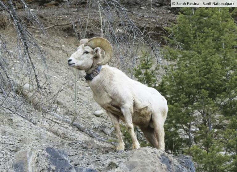
Working with VECTRONIC Aerospace, NDOT and Nebraska Game and Parks obtained solar-powered GPS collars equipped with remote satellite communication and attached them to seven bighorn sheep. This enabled real-time monitoring of the animals in the study area.
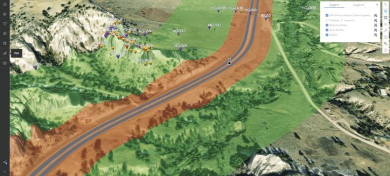
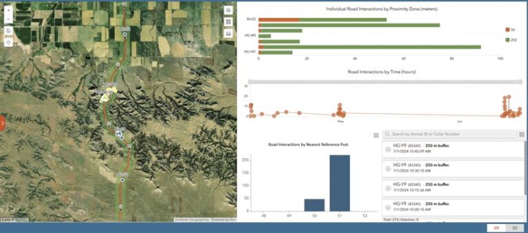
Research team members then employed ArcGIS Online to store and facilitate real-time analysis of the resultant data. The team also leveraged ArcGIS Online to create maps of the bighorn sheep’s movements, including 3D maps that showed, for example, when sheep were on a mountain overlooking the highway. The team used ArcGIS Dashboards as well to create dashboards that revealed the movements of bighorn sheep, displaying how many were in the vicinity of roads and how often this occurred. Taken together, these tools provided a more accessible and comprehensive view of the GPS collar data, simplifying information sharing and collaboration across the organizations.
The team also used ArcGIS Velocity to conduct real-time analysis of the incoming GPS collar data. The analysis process included enriching the data with motion statistics, direction of travel, and proximity to road features, as well as calculating distances to known locations to generate near real-time notifications for wildlife managers. Additionally, Velocity offered big data analytic capabilities for long-term analysis. This greatly streamlined the analysis process, which traditionally was done by downloading static spreadsheets and geoenabling them before any kind of analysis could even begin.
VECTRONIC Aerospace’s solar-powered SOLEX Collar sends information about its position every 15 minutes. Velocity took that information and processed it right away, finishing location analysis in 40 seconds. The system notified Nebraska Game and Parks wildlife managers when bighorn sheep were 50–250 meters from a highway. The wildlife managers could then call the sheriff or other wildlife officers out to that area to help reduce the chance of vehicles colliding with the bighorn sheep.
Real-time data is not only crucial for preventing wildlife-vehicle collisions, but it can also serve as an early warning system for researchers when radio-collared, wild bighorn sheep interact with other species. This capability could prove pivotal in containing the transmission of diseases between bighorn sheep and other animals, which can result in dramatic population decreases and necessitate the costly culling of herds.
“This collaborative effort utilizing new, innovative technology will contribute greatly to species, like bighorn sheep, in need of conservation and will serve us well in developing a variety of mitigation strategies addressing future challenges,” said Todd Nordeen, manager of big game and disease research for the Nebraska Game and Parks Commission.

Current Insight Informs Future Research
As a result of integrating the GPS collar data with ArcGIS Online and ArcGIS Velocity, wildlife managers were able to proactively monitor bighorn sheep movements in real time to prevent possible wildlife-vehicle collisions and strategically prepare for future wildlife crossings. Being able to view the data derived from the GPS collars in dashboards gave wildlife managers insight into past trends and highway activity.
NDOT staff expect the bighorn sheep collar data “to be an asset in our feasibility study as we seek to improve our understanding of movement patterns and potential mitigation strategies to enhance the safety of both the traveling public and wildlife in the Wildcat Hills region along [Nebraska Highway] 71,” said Jarrod Walker, highway planning manager for NDOT.
The Wildcat Hills pilot study, which began in 2024, has already provided valuable data that will inform the planning of secure and sustainable wildlife corridors in Nebraska. The insight gained from this study will also guide future research on monitoring wildlife movements, mitigations, and potential disease transmission. The use of this technology greatly expands the opportunities to safeguard both humans and wildlife, such as by triggering DOT alerts when animals are in the area so motorists are reminded to stay alert and slow down.
“We look forward to developing solutions for big GPS datasets generated by our wildlife collars to make it easier for our clients in Nebraska and around the world to streamline the data analysis in Esri’s ArcGIS platform,” said Chris Kochanny, CEO and president of VECTRONIC Aerospace.

