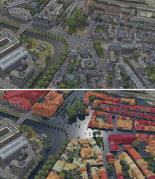
An insurance agent needs to identify affected policy members after a hurricane. A United Nations operations commander needs to ensure the safety of a convoy that’s delivering aid to a small, remote village. A park director who’s trying to stem illegal poaching activities needs to maintain awareness of what’s happening in and around the nature reserve.
In each of these situations, imagery can help people understand changes in landforms and infrastructure over time. When new imagery of the area of concern becomes available, it needs to be processed, shared, and analyzed quickly to provide the insurance agent, operations commander, and park director with the information they need to get their jobs done.

Various organizations in many sectors—such as government; agriculture; and architecture, engineering, and construction (AEC)—turn to imagery to make critical decisions that affect their success and the communities they serve. For these organizations, it’s vital that they’re able to share datasets with stakeholders and ensure that the right information is available on time.
ArcGIS provides a comprehensive imagery system with flexible data management and storage solutions, extensive sensor support, comprehensive imagery processing and analysis capabilities, and data sharing options that are quick and secure. Read on to get answers to some common questions about making imagery a seamless part of GIS workflows.
How do I ensure that my stakeholders can access the imagery they need, when they need it?
During a rush job or an event like a natural disaster, the way users process and store imagery needs to be flexible. Say a user collected drone imagery of damage from a tornado, but they are in a remote area with no way to connect to the internet. They’d need to be able to process, visualize, and analyze their imagery offline.
They would also need to host and share this imagery as soon as they gained access to the internet again so that others could view it on demand and even take it offline. In a situation like a tornado, the user would need to get the data served out quickly to first responders, internal stakeholders, and sometimes the public. They probably wouldn’t have time to manually set up servers to host and share the imagery.
Flexible Imagery Deployment Options
The ArcGIS Image suite extends ArcGIS Pro, ArcGIS Enterprise, ArcGIS Online, and imagery that’s already stored in cloud environments to provide flexible deployment options that support image management and analysis based on an organization’s infrastructure and data requirements. With these deployment options, internal and external stakeholders, including the public, can access the latest imagery as a scalable image service via desktop, mobile, and web browser clients in online and offline environments.
In a natural disaster situation, transforming processed imagery into on-demand image services makes it easy for stakeholders to access the imagery they need when they need it. These image services are scalable and responsive, depending on what an organization requires for its workflows.

Will all the imagery I collect be supported and performant?
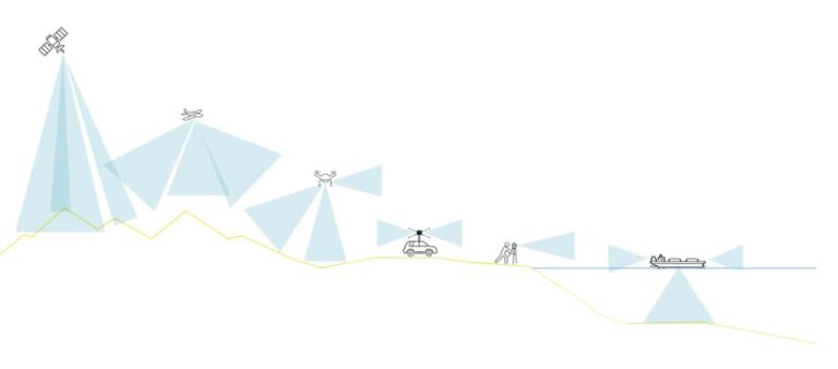
The sheer number of sensors now available to capture imagery is staggering. More earth observation satellites are deployed each year—not to mention drones and planes, along with radar, lidar, and terrestrial sensors.
In situations like disaster response, it is critical that the imagery from various sensors—in its varied formats and with its associated metadata—be supported and optimized so that stakeholders can access and exploit the data to streamline response efforts. In times of crisis especially, users need to have the option to restructure data into cloud-optimized formats and process it quickly to make it accessible to those who need it.
Vast Support for Imagery Sources and Formats
ArcGIS provides a single system that integrates various data sources and supports nearly all available sensors and imagery formats. ArcGIS supports more than 150 image formats, as well as compressions such as Limited Error Raster Compression (LERC). Esri has also created cloud-optimized formats and structures, such as the Cloud Raster Format (CRF), which is used for reading and writing large datasets like multidimensional raster data. For sensors that are not directly supported by ArcGIS, users can add these sensors to their workflows by customizing raster types in Python to reformat their metadata.
In terms of performance, ArcGIS allows users to stream image services that have been saved as tiled imagery layers and dynamic imagery layers. This provides stakeholders with the speed they need when performing analysis and feature extraction without compromising the metadata and bands associated with the imagery. Users can also share imagery as hosted tile layers to optimize performance for visualization purposes.
Where and how should I manage and store my imagery?
As organizations employ more imagery, the costs associated with storing that imagery need to be taken into consideration.
Traditionally, images were primarily stored locally on computers or in network-attached storage devices. If the images needed to be shared, the data generally had to be stored on disks, which then had to be physically shipped to stakeholders.

Now, many organizations have embraced cloud storage, where imagery can be quickly uploaded and made available for analysis and visualization. This is a scalable solution that makes it easier to share imagery data with stakeholders, increase storage as imagery volumes grow, and provide openly accessible data to anyone who needs it.
Organizations that are accustomed to using local storage may want to use cloud storage as their imagery data stores get larger—especially if the data is maintained by one team or individual. They may even want to perform their analysis in the same cloud region as their imagery data.
Adaptable Imagery Management Practices
With ArcGIS products, users can adapt their management practices as the amount of imagery their organizations use increases and usage patterns change. Imagery curators can have full control over how data is managed, processed, and shared across the entire organization. Individual users or managers can also upload imagery to the cloud and host it there. This makes it easier to share the imagery and control who can access it by setting permissions.
Products in the ArcGIS Image suite allow users to access and store imagery in the cloud, on-premises, and even in an organization’s own cloud environment (which ensures efficient computation and reduces egress costs when data needs to be moved to the processing location). Additionally, ArcGIS can catalog stored imagery and metadata, making it easier for users and stakeholders to search and discover imagery collections.
How can I gain actionable insight from imagery?
Typically, imagery analysts, GIS analysts, and remote sensing scientists process and analyze imagery to gain actionable insight. These experts often need to make simple enhancements to the images to see things like vegetation health or the parameters of an active fire under a bed of smoke. They can also perform more complex operations, such as orthorectification and automated feature extraction.
The tools used for image processing and analysis must be adaptable to support all dataset sizes; handle many images simultaneously; run a wide range of analysis tasks with local, regional, and global functions; work with raster and vector data; and be scalable.
Extensive Image Analysis Tools
With the ArcGIS Image suite, users have access to extensive image analysis tools that can help them understand change, see trends in multidimensional data, develop and test analyses on small areas captured in imagery, and scale up analysis—to the entire world, if needed. Users can employ machine learning, deep learning, geoprocessing tools, and raster functions to perform analyses.

