The Road Ahead for ArcGIS
Cloud Services, Hosted Map Content, and the New Runtime at ArcGIS 10.1

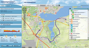
The schleswig-holstein online bike routing portal allows tourists to plan and map their itineraries between 2,500 points of interest, taking into account average speed, terrain, and weather forecasts. See more cloud services articles throughout this special issue.
The primary theme for ArcGIS 10.1, which is expected to be released in early 2012, is sharing and collaboration. Users will find that this release makes it simpler to put mapping and geospatial analytics into the hands of more people without requiring that they be GIS experts. ArcGIS users will be able to deliver any GIS resource, such as maps, imagery, geodatabases, and tools, as a web service. The ability to access these services will be built into ArcGIS, as well as any application built with one of the ArcGIS APIs.
With this release, cloud computing—both public and private clouds—will play an increasingly critical role in how users get their work accomplished. ArcGIS software will take advantage of the powerful, scalable, and ubiquitous nature of cloud infrastructures to store and distribute geospatial content. Users will be able to easily package their maps and layers and make that content available to staff, stakeholders, partners, or the public via online groups while maintaining complete control and ownership of their content. Additionally, users will be able to quickly deploy GIS servers in the cloud when they need them as fully functional production systems for publishing services and supporting desktop, mobile, and web applications.
At 10.1, ArcGIS for Server will run natively on 64-bit operating systems. Users will notice significant performance improvements for activities such as web editing, map caching, spatial analysis, finding addresses, and using imagery.
Imagery will also be better integrated into the core of ArcGIS. ArcGIS will not only make it simpler to use imagery but also support more imagery sources, as well as lidar and radar.

This lightweight application for the City of Newport Beach, California, was built using ArcGIS API for JavaScript. It allows easy access to the city's GIS data.
An exciting addition to ArcGIS at 10.1 will be ArcGIS Runtime, which lets developers create and deploy focused, stand-alone GIS applications for desktop users, who have been asking for a small, lightweight deployment that, in terms of capabilities, fits between ArcGIS Engine and the ArcGIS Web Mapping APIs. The new runtime is designed for both desktop and cloud development. It has a fast display and does not require installation; it can be run directly from a CD. The learning curve for the new runtime is expected to be very gentle for developers familiar with the web APIs.
In addition to these enhancements to ArcGIS, Esri has also concentrated on providing core GIS tools to help users create better maps. These tools range from dynamic legends to contextual generalization, the ability to track edits, parcel editing tools, analysis tools, and a whole lot more.
Finally, as Esri moves toward ArcGIS 10.1, Python is becoming foundational to ArcGIS. It essentially bridges the gap between GIS analysts and programmers.
Learn more about what's coming in ArcGIS 10.1 by visiting esri.com/whatscoming.
See also "A Note About Names."