GIS Aids Recovery of Post-Tsunami Indonesia
 The tsunami in the Indian Ocean in December 2004 damaged or destroyed more than 150,000 houses and 3,000 kilometers of road. About 175,000 people were killed and 600,000 more were left homeless. | |
 UN HIC worked with WHO to collect and evaluate data using ArcGIS to create an accurate picture of damage and prioritize need. |
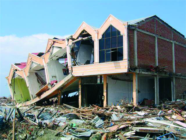
December 26, 2004, ushered in the largest natural disaster in recent history. A magnitude 9.1 earthquake and resulting tsunami brought incredible devastation to many countries in Southeast Asia, killing approximately 185,000 people worldwide. Countries such as Sri Lanka and Thailand saw massive human casualties; houses, roads, hospitals, and even entire villages were destroyed.
No country was affected more than Indonesia. A wave purported to be 30 meters high hit the province of Nangroe Aceh Darussalam (Aceh) on the northern tip of Sumatra. The tsunami ravaged 800 kilometers of coastline, and in some villages up to 90 percent of the residents lost their lives.
For a region already suffering from neglect and civil turmoil, even a small emergency would have been difficult to handle. Faced with such an insurmountable event as the tsunami and ensuing magnitude 8.6 earthquake a few months later, the nations ravaged by the devastation probably would have struggled if not for the help of the world community. Many countries rallied to the region's aid seemingly overnight and launched the largest relief effort ever undertaken.
From the beginning, geographic information system (GIS) technology played an important role in guiding emergency responders to areas where people died or were injured and infrastructure was damaged. The destruction affected all levels of service, including water, sewer, and electricity, all of which had to be reestablished in the communities. Even transporting supplies, laborers, and rescue workers to the devastated regions of northern Sumatra was hampered since the single road along the west coast had been either severely damaged or completely washed away in large sections.
Within days of the tragedy, the United Nations (UN) set up a Humanitarian Information Center (HIC) in Sumatra. Based in tents in the heart of the catastrophe, HIC collected data from the Indonesian government, nongovernmental organizations (NGOs), and international agencies. Using Esri ArcGIS software, UN HIC delivered this information, including GIS data and maps, to the responding humanitarian community of more than 65 international agencies and NGOs, allowing it to deliver assistance more effectively right after the emergency.
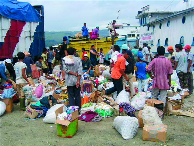 GIS was used to plan movement of trucks and prioritize shipments of goods throughout the region. Credit: Joerg Meier, Aceh Besar |
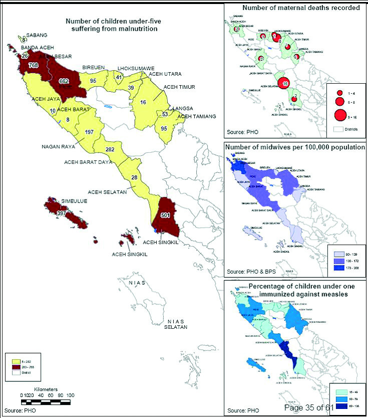
Among the most valuable products that UN HIC produced was a map of where each organization was working so that information could be communicated quickly to relief workers, ensuring that food, water, and shelter were delivered as soon and as effectively as possible. During the initial response, GIS was used across many sectors-including health-where maps were collated and evaluated for a clear picture of need, prioritizing the building of field hospitals and health clinics.
As the relief efforts transitioned into recovery and development, the focus of UN HIC shifted as well. In September 2005, HIC was renamed the United Nations Information Management System (UNIMS), and its mission changed to reflect the need for better coordination with the Indonesian government as well as to continue to meet the high demand for GIS during the next rehabilitation and reconstruction phase.
Data collection, collation, and dissemination continued to be provided at no cost to the agencies that needed it. UNIMS furnished ArcGIS software and a staff of 40 to keep up with demand, which included the creation of necessary maps for government and humanitarian agencies, data gathering, quality assurance, and maintenance of the data for Aceh Province.
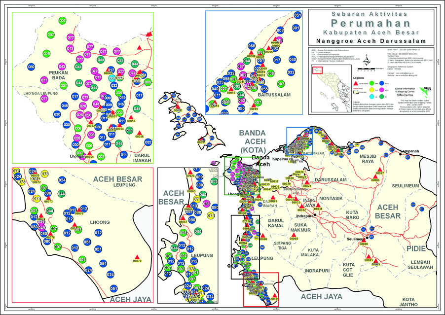 One of the most important maps used in the beginning of the recovery effort was a map created by UN HIC that listed what international aid agencies were working in the different regions. |
UNIMS transitioned to the Indonesian government in February 2006 as the Spatial Information and Mapping Centre (SIM-Centre) was established as part of a temporary building and reconstruction arm of the Indonesian government in the province. Badan Rehabilitasi dan Rekonstruksi (BRR) NAD-Nias continues to oversee the work of the humanitarian agencies and ensure that the needs of the local population are met. It will function until the middle of 2008, when its activities will be absorbed into the standard provincial departments of the Indonesian government. To prepare for this, SIM-Centre is working to build sustainable GIS capacity at the provincial and local government agency levels by providing training and coordinating GIS activities within the government as well as creating an online data catalog and mapping tools.
Find out more by visiting the special display GIS Aids Recovery of Post-Tsunami Indonesia at the Esri International User Conference, June 18-22, 2007, in San Diego, California. The display will be in the Sails Pavilion on the third floor of the San Diego Convention Center.