ArcWatch: GIS News, Views, and Insights
April 2011
Baltimore City Fire Maximizes Workforce, Resources with GIS
By Jesse Theodore
Esri Writer
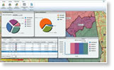
Two members of the Baltimore, Maryland, City Fire Department spearheaded an effort to implement GIS within the agency. Jim Potteiger and Peter Hanna used GIS to support decision making on a number of fronts, including helping devise strategies to meet response times set by the National Fire Protection Association (NFPA). The department also uses GIS to plan and manage major events in the city such as auto races. Baltimore City Fire also created a web application using Esri's ArcGIS API for Flex, deployed on ArcGIS Server, which quickly and easily provides building information to firefighters. Read this article.

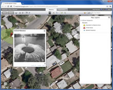
This web mapping application for the Baltimore City Fire Department provides vital information to firefighters about condemned buildings in the city.
Tip of the Month
Crowdsourcing in Your Community: Map Neighborhood Problems by Using ArcGIS Explorer Online
In the new version of ArcGIS Explorer Online, you can use the Citizen Request template to map a neighborhood problem such as flooding, graffiti, or potholes. Read this tip to learn how.
Connect with ArcWatch
ArcWatch is published monthly by Esri and contains GIS news, practical advice, and updates about the company's software and events. To submit article ideas, e-mail editor Carla Wheeler at arcwatch_editor@esri.com.
Blog Spotlight
If you study water or work on water-related projects, keep up with the world of GIS and hydro by tapping into the Hydro Blog.
Geospatial View of a Disaster
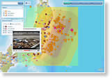 Cameras captured—live, in some cases—the horrific destruction wrought by a magnitude 9.0 earthquake and resultant tsunami in Japan. GIS offers a geospatial view of what occurred over space and time, including where a cluster of more than 165 quakes occurred before and after the massive temblor struck. In this article, Esri education manager Joseph Kerski describes some GIS mapping resources you can use to learn more about the natural disaster in Japan from a spatial perspective.
 ArcGIS Online: What's New?
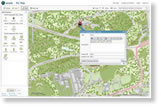 The new version of ArcGIS Online lets you add pop-up windows, create editable layers, and use time-enabled web maps using the ArcGIS map viewer or ArcGIS Explorer Online. You can then share and use these maps in other ArcGIS clients such as ArcGIS Desktop and ArcGIS for smartphones. Read the article.
Try ArcGIS Viewer for Microsoft Silverlight
Esri's new ArcGIS Viewer for Microsoft Silverlight can now be downloaded at no cost from the Esri Beta Community site. The viewer is a ready-to-use, configurable web mapping application built on ArcGIS API for Silverlight/WPF. You can easily configure this viewer without writing a single line of code or editing configuration files.
Crisis Response: GIS in Cyberspace
Emergency response on the ground during disasters requires integrated solutions informed by geospatial technologies and digital databases. Visualization and spatial applications are critical before, during, and after the incident to manage the disaster and response. In this article, Melinda Laituri explores how online and mobile technologies play a critical role.
Newsroom
Mapping the Latest from Libya
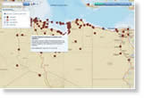 Monitor what's happening on the ground in Libya by following the crowdsourced social media conversation. Esri's Libya Unrest Map pulls in the latest YouTube videos, Ushahidi reports, Twitter posts, and more, from the troubled nation.
Track Natural Disasters with Global Incident Viewer
Stay updated about the latest earthquakes, volcanic eruptions, and tropical cyclones using this Esri online mapping application.
Share Your Work at the Esri UC Map Gallery
Submit your hard-copy or digital maps that demonstrate your innovative GIS work for the 2011 Esri International User Conference (Esri UC) Map Gallery. The deadline is June 10.
Try Community Analyst Free for 90 Days
Community Analyst lets you access thousands of demographic, health, economic, education, and business data variables combined with instant reports and interactive maps. Test it in beta for free.
Video: ArcGIS System and Productivity
Esri's John Calkins, Pat Dolan, and Katie Clift talk about enhancements in ArcGIS 10 that will help make you more productive, whether you are working on a GIS project in the office, the field, or at a coffee shop. Watch the video.
Find the Closest Nuclear Plant
Locate nuclear power plants in the United States and view related data such as fault lines, tectonic boundaries, and historic earthquakes using this online Esri map.
Augmented Reality and Geographic Literacy
Daniel C. Edelson of the National Geographic Society writes about the promise of augmented reality and mobile devices for geographic learning. Read his article.
Download the New Situation Awareness Template
Esri Redistricting Solution
 State and local governments, legislators, and advocacy groups can use the new, web-based Esri Redistricting solution to create and share redistricting plans. The solution lets you collaborate with others on redistricting plans, create different versions of redistricting scenarios, and then share the final plan with stakeholders, including citizens. Try a free, 30-day subscription.
GIS for Disaster Planning
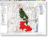 Using the 2009 Glenrosa fire in British Columbia, Canada, for the scenario, this ArcGIS 10 exercise shows how the ArcGIS Network Analyst extension can be used to identify at-risk residents and then route them from homes or workplaces to safety. Read the tutorial.
New Edition of Thinking About GIS
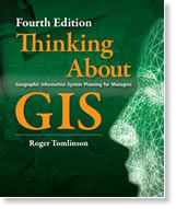 Roger Tomlinson's Thinking About GIS: Geographic Information System Planning for Managers helps organizations prepare for and succeed at implementing or expanding a GIS. The book, now in its fourth edition, also contains exercises from Tomlinson's Planning a GIS training course and includes a video of his presentation, Planning and Managing a GIS, at the Esri International User Conference. Buy the book.
Technical Talk
View from the DevSummit
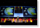 More than 1,350 developers from around the world converged on Palm Springs, California, for the 2011 Esri Developer Summit. What drew them? Like Adam Knight, they wanted to find out how the ArcGIS platform will help them build new and improved web, mobile, desktop, and other applications. "The possibilities are enormous," said Knight, a first-time attendee. "I think [the summit] is important for developers to attend because of the 'wow, I can do that?' effect. Learning what is possible is a key component to writing great applications for users." Read this article to learn what's on the horizon in GIS technology for developers.
Demo: Analysis Tools in ArcGIS 10
In this video, Esri's Lauren Rosenshein demonstrates the new and improved network analysis tools in ArcGIS 10, including location-allocation.
Join the Esri Beta Community
Shape the next generation of Esri software and services by becoming a member of the Esri Beta Community. It's where GIS users can test Esri's latest software before public release.
Learn to Evaluate Regression Models
Walk through the process for evaluating regression models using a checklist of six items and the Ordinary Least Squares (OLS) and Geographically Weighted Regression (GWR) tools in the ArcGIS Spatial Statistics toolbox.
Using the Swipe Tool in ArcGIS Explorer Desktop
Esri's Bern Szukalski explains how to use the Swipe tool to compare imagery of areas in Japan before and after the recent tsunami.
Correctly Use the Buffer Tool in ArcGIS
Read this article to learn about buffering and how to properly use the popular Buffer tool, a geoprocessing tool in the Analysis toolbox in ArcToolbox. The tool generates buffer polygons, or offsets, around input features at a specified distance.
Converting and Displaying Coordinates in ArcGIS 10
Tip: Symbolizing Trees in ArcGIS 10
Constructing Features with Precise Measurements
Spatial Roundtable
 Spatial Analysis Helps Utilities Manage Risk
Bill Meehan, Esri's director of utility solutions, explores how utilities may improve risk models by incorporating web-based data, knowledge from experienced employees, and spatial analysis capabilities. Join the conversation at the Spatial Roundtable.Study Impacts of Nuclear Incidents
The Nuclear Impact Map lets you study the demographics of the population within 10, 20, 50, and 100 kilometers around the damaged nuclear power plants in Japan. You may select among four basemaps to use; add earthquake data to the map; and monitor social media related to the nuclear power plant incidents, the tsunami, and the magnitude 9.0 earthquake that triggered the disaster.
Web Resources and More
Explore the Arctic with GIS
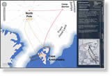 Use this interactive map from Esri (UK) Ltd. to follow, via the Royal Geographical Society's annotated maps, the historic expeditions of Sir William Edward Parry and other explorers who attempted to reach the North Pole. The basemap also charts the recent trek to the North Pole by the Walking with the Wounded team.
Watch Introduction to the ArcGIS API for iOS
Developers can add GIS maps and tasks to custom applications designed for iOS devices using ArcGIS API for iOS. To learn more, tune into the live training seminar Introduction to the ArcGIS API for iOS on April 28, 2011.
Mobile GIS: Getting Started with the ArcGIS API for iOS
Register for this new web course on how to use ArcGIS API for iOS to develop interactive mobile applications for iOS devices such as iPhone, iPod touch, and iPad. You will learn to develop applications that feature GIS data, maps, and functionality.
CitySourced: An SaaS Mobile Platform for Civic Engagement
Jason Kiesel and Kurt Daradics, cofounders of CitySourced in Santa Monica, California, discuss their citizen reporting app, which is available for BlackBerry, iPhone, Android, and Windows Phone platforms.
Download GIS Best Practices: Higher Education [PDF]
This new booklet [PDF] describes how GIS technology is applied in teaching, research, and administration at leading universities and colleges.
Print Wall Maps from the World Topographic Community Basemap
Skills Review Courses for the Esri Technical Certification Exams
 Hardware Offers
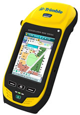
The new GeoCollector for ArcPad offer [PDF] for US customers is based on Trimble's new GeoExplorer 6000 series. Choose either the 10 centimeter (GeoCollector XH) or 50 centimeter (GeoCollector XT) differential accuracy. Two of the solutions include Floodlight satellite shadow reduction technology to deliver more positions and better accuracies under difficult conditions. Learn more about all Esri and Trimble offers.
Visit the Esri Store to find more software and extensions, upgrades, data, books, and hardware bundles.