ArcWatch: GIS News, Views, and Insights
March 2012
Keeping the Electric Vehicle Alive
By Jessica Wyland
Esri Writer
Nashville Electric Service (NES) in Tennessee tapped into Esri ArcGIS technology as it prepared for an upsurge in electric demand from owners of the Nissan Leaf. Nissan just began selling the Leaf in the Nashville area, one of its "launch markets."
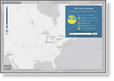
If the utility infrastructure was not ready to meet increased electricity use, customers could experience power outages. Keith Brown, principal associate engineer for the NES Design Engineering, Distribution Planning Group, and NES senior engineer Carla Nelson compiled and analyzed a complex collection of data, then used ArcGIS to create Predicted Electric Vehicle Adoption maps. These maps showed where the people who were likely to purchase the electric vehicles lived.
"If people come home from work around four or five o'clock in the afternoon on a hot day, plug in their electric vehicles, and turn on their air conditioners, we have to build up the infrastructure to serve that load," Brown said. Read the article.

Esri ArcGIS technology was used to create these heat maps, which show in red where Nashville area residents, based on criteria such as age, education, and political affiliation, were more likely to adopt electric vehicles.
Tip of the Month
Learn a New Method for Displaying Hillshades and Elevation Tints
Learn about a new way to overlay colors on hillshades that keeps your original colors and detail. Read this tip.
Connect with ArcWatch
ArcWatch is published monthly by Esri and contains GIS news, practical advice, and updates about the company's software and events. To submit article ideas, e-mail editor Carla Wheeler at arcwatch_editor@esri.com.
Join the Conversation
Esri UC: Where to Get Inspired
 When registration opened for this year's Esri International User Conference (Esri UC), Tom Beckett of Kern County, California, was at the front of the line. Beckett, a technology services supervisor for the county, was the first registrant out of the 300 people who signed up on December 13, 2011. After attending his first Esri UC last summer, why is he raring to return? Read the article.
What's Next for Web GIS?
 Pinde Fu, coauthor of Web GIS: Principles and Applications, talks about what the future holds for web GIS, including how it will be used in education and research. He also explains how mobile devices will likely surpass desktops and notebooks as a primary client platform for web GIS. Read the interview with Fu. Buy his book.
Get Basic Training on ArcGIS 10.1
In this video from the Esri Federal GIS Conference, Esri staff demonstrates a wide array of new technology, including ArcGIS 10.1 and Esri CityEngine. See the new and improved tools and applications you will use.
The Esri Federal GIS Conference
US Department of the Interior deputy secretary David J. Hayes talks about the importance of GIS in this Esri Federal GIS Conference keynote. "You have been on the ground floor of what I think is the most important new tool for decision makers in the federal government—bar none," Hayes told the audience.
Newsroom
Campaign Contribution Poll
 Americans support presidential contenders in different ways. Some donate money to the campaign, others volunteer or put up yard signs, and the rest only give the candidates their votes. Esri's 2012 Presidential Campaign Contribution map lets you enter your ZIP Code and participate in a poll on how you throw your support behind a candidate. Vote or just view the map's results.
Exploring Threats to Coral Reefs
The World Resources Institute uses GIS to create highly detailed maps of threats to coral reefs around the world. Read the article.
Using GIS for Coal Mine Reclamation Projects
Ayres Associates of Eau Claire, Wisconsin, used Esri's ArcObjects to develop a user interface called easiTool, which automates the workflow of watershed erosion modeling for coal mine reclamation. Read the article.
GIS Helps Track 11.5 Million Animals in Uruguay
The country's National System of Livestock Information uses GIS technology to monitor information about cattle and other livestock. Read the article.
Teaching Young People to Observe their World
Understanding our world starts with observing our world, says Daniel C. Edelson of the National Geographic Society. He stresses the importance of turning students into old-fashioned geographers through citizen science, public participation in research, and volunteered geographic information initiatives. Read the article.
ArcGIS App for iPad 2
 In this article, Rory Biggadike of WebMapSolutions.com describes the process of building an ArcGIS application using ArcGIS API for Flex 2.4, porting the code to Adobe AIR, and installing the application on an iPad 2. Watch this video showing the application in action.
The GIS Encyclopedia
 The GIS community contributes to Wiki.GIS.com, so visit this valuable resource on a regular basis to learn more about geospatial technology, terminology, upcoming events, GIS trivia, and much more.
Mapping the Nation
 Mapping the Nation: Government and Technology Making a Difference illustrates how a variety of US agencies use GIS technology to address social, economic, and environmental issues. The book uses visually striking maps to show how GIS-powered government services cultivate an atmosphere of collaboration and allow agencies to achieve their goals. Buy the book.
Zen and the Art of GIS Communication
Story Map: Trends in Unemployment
Technical Talk
Earn an Esri Certification
 Demonstrate your skills! The Enterprise Geodatabase Management Professional exam for geodatabase experts is now available for you to take. If you have 5-7 years of experience as a database or GIS administrator and understand the components and architecture of the geodatabase, this may be a great way for you to advance your career and distinguish yourself from your peers. If your expertise is not in this area but you have colleagues or friends who might be interested, please tell them about this new certification.
Where Developers Go for GIS Know-How
Find out all you need to know about where GIS technology is heading at the Esri Developer Summit, which will be held March 26-29, 2012, in Palm Springs, California. Though the summit is only days away, there's still time to register.
Map Orientation: When True North Isn't at the Top
In some cases, mapmakers do not draw their maps with north at the top. Find out why in this blog post from Esri's Aileen Buckley.
Catching Up on the (Private) Cloud
The business world is well aware of the public cloud's benefits. Find out more about the parallel universe of private clouds and what Esri offers in this realm. Read this Esri Insider blog post from Esri strategies architect Victoria Kouyoumjian, who discusses Portal for ArcGIS and ArcGIS Online for organizations.
Los Angeles County Maps Solar Potential
LA County Solar Map is a simple, elegant map that generates sophisticated solar calculations for any building in the county. Read the article.
Spatial Roundtable
 Better Decision Making at the DOTs
How can large departments of transportation (DOTs) overcome problems related to data integration and information access in order to foster more intelligent decision making? Esri transportation industry manager Terry Bills answers the question and asks you to weigh in at the Spatial Roundtable.What to See, Do in San Diego
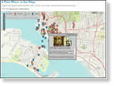 Suggest a place on this map to eat, shop, or sightsee in San Diego, California, and share it with colleagues who plan to go there for the Esri International User Conference this summer. Read this Esri UC blog post for other ideas about where to spend your free time and where to find a place to stay.
Tip: Creating Pie Segment Shapes as Features
Video: Synchronizing Data between Local Office and Cloud Geodatabases
Join the Esri Developer Network
Web Resources and More
Easy Web-Based Analysis
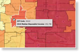 Where's the spending power in your community or state? Business Analyst Online (BAO) can show you by mapping net worth and disposable income. See how the technology works by typing in your ZIP Code here. Then get a free 14-day trial of BAO.
Podcast: Understanding the American Consumer
Ad Age's director of information Matt Carmichael talks about how his magazine uses Esri's GIS technology and data to help tell stories about demographic and consumer trends. Listen to the podcast.
How Maricopa County Uses GIS for Elections and Redistricting
In this podcast, Maricopa County, Arizona, recorder Helen Purcell talks about how GIS technology saves time and money in managing redistricting and elections. Listen to the interview with Purcell.
Learn about ArcGIS Online Subscriptions
Esri will host the free live training seminar, ArcGIS Online Subscriptions—Mapping and GIS for Organizations, on April 12, 2012. Learn more about this seminar and subscribe to reminders for upcoming seminars.
Watch Free Training Seminars
Tune in to the recording of January's live training seminar, Introduction to the ArcGIS Runtime SDK for Android, and see a list of other seminars.
Cartographers' Favorites: Color Pickers, Tools, and Other Mapmaking Resources
Explore the Diversity Maps
Hardware Offers
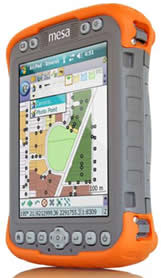 US customers can take advantage of special discounts on all Juniper Mesa Geo Rugged Notepad offers through June 2012. This includes ArcPad with a Juniper Mesa Geo Rugged Notepad [PDF], Juniper Mesa Geo Rugged Notepad for use with ArcGIS for Windows Mobile for ArcGIS for Desktop [PDF], or Juniper Mesa Geo Rugged Notepad for use with ArcGIS for Windows Mobile for ArcGIS for Server [PDF]. The Mesa Geo Rugged Notepad features advantages of both a Tablet PC and a rugged handheld computer and includes an integrated digital 3.2-megapixel color camera.
Visit the Esri Store to find more software and extensions, upgrades, data, books, and hardware bundles.