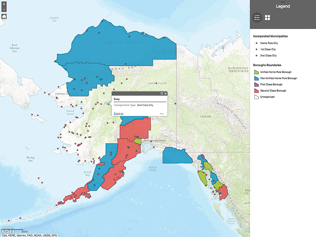
Although the State of Alaska does not levy sales or individual income taxes—depending instead primarily on petroleum revenues and federal subsidies to finance government operations and services—each of its 164 independent municipalities can levy their own sales and property taxes.
That makes the job of amassing municipal tax revenue data and creating an accessible, understandable document that communicates that information challenging for Alaska’s Office of the State Assessor (OSA). Housed within the Municipal and Community Policy and Research Section of the Division of Community and Regional Affairs (DCRA) in the Alaska Department of Commerce, Community and Economic Development (DCCED), OSA is tasked with communicating the tax information and the nuances of each tax code in context for legislators, OSA staff, businesses, and the public. In addition to the variability and complexity of tax codes, Alaska is vast, and many of its communities are located in remote areas that are difficult to reach physically or contact via phone or the Internet.

OSA pioneered the use of Survey123 for ArcGIS to capture tax data and present the information in an interactive and accessible manner using an Esri Story Maps app called Alaska Taxable 2016 (esri.com/AlaskaTaxable2016). The story map has made the work of OSA even more valuable. Using narrative, interactive maps and dashboards, it simplifies complex tax information and makes it highly consumable.
A Big Job
OSA is required by law to gather the taxation information for every municipality in the state and publish it each year. This is a formidable job. At 665,000 square miles, Alaska is the largest state in the United States and, at the same time, is one of the most sparsely populated. A portion of its citizens live in small, remote communities scattered across the state or hugging its rugged coast.
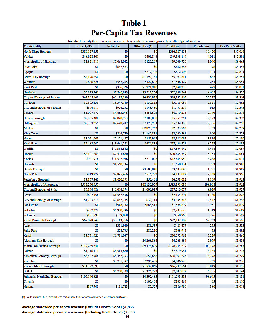
After the tax information is gathered, it is published and provided to state legislators and their staff as a printed document or a PDF file known as Alaska Taxable. In either case, the data is presented primarily as pages of tables that contain the current taxes levied, rates, and revenue details for all municipalities.
For many years, municipal taxation information, including exemptions, rates, and revenue data, was compiled into a complex, massive Microsoft Excel workbook. “Depending on who was using it, the spreadsheet could be a masterpiece or a very confusing representation of taxation information,” said Ron Brown, the assistant state assessor. The workbook, with its tangle of interdependencies, had become so complex over the years that only Brown and one other person could work with it successfully.
Clearly, OSA needed to figure out how to reduce its dependency on complicated processes, but it had an even more pressing problem. Brown is planning to retire in 2018, and there was a real danger that his detailed knowledge of Alaska Taxable might also depart. This highlights an issue faced by many organizations as increasing numbers of the baby boomer generation leave the workforce.
“We were facing a real problem of carrying forward the institutional knowledge of how this information came together,” explained Brown. OSA needed to get it out of Excel and into something that was not so highly dependent on just a couple of people. Finding a new way to generate Alaska Taxable without relying so heavily on the complex processes associated with the workbook was needed sooner rather than later.
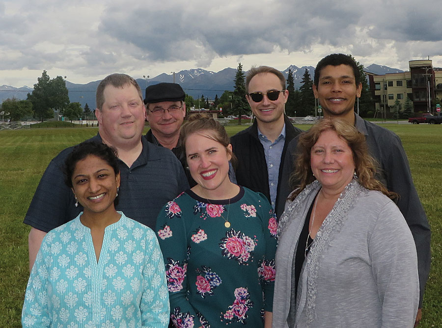
To simplify the creation of Alaska Taxable and retain the organizational knowledge associated with it, Manjula Boyina, research analyst with the Municipal and Community Policy and Research Section, and her small team composed of Grace Beaujean and Jade Bickmore (who were also research analysts within the section); Lorence Williams, a publications specialist; and George Plumley, a planner, and the only team member who had previous GIS experience, worked with Brown to implement an ArcGIS solution.
“Unlike past software projects where IT consultants were retained with a pretty fixed set of requirements, this new solution was an experiment in building capacity in-house,” said Boyina.
Better Data Collection
The first part of the solution was finding a more efficient way of gathering tax data. The team decided to use Survey123 for ArcGIS, then in early beta, as part of its efforts to improve this task.
To collect data from the municipalities, OSA required municipalities to supply assessment information in an Excel form and the tax and debt information on two separate paper forms. These forms were sent out, returned, and checked for accuracy and completeness before the data was entered by OSA staff.
Checking data for consistency since the last report, verifying calculations, and correcting data entry errors are important steps because staffing at municipalities varies widely from experienced, dedicated staff to new or part-time employees who may not be familiar with the reports.
As the team considered the input process, it found ways to improve these forms. The short forms were combined into one survey to condense the data entry process. They also realized that the long form was convoluted and repetitive. “We collected the same data multiple times in multiple places. This made our output from the larger survey too long and unwieldy,” said Beaujean. Consequently, they condensed and reorganized the long form and will use that for the 2017 data collection.
In 2016, paper surveys were sent out. After the returned forms were checked, as usual, staff entered the data into two forms that had been created using Survey123 Connect. At that point, the Survey123 website was not yet available, and connectivity was an issue for some municipalities. By condensing and reorganizing the surveys, the team had already made the input process quicker, and further refinement will cut the output from the survey by half.
The survey building team of Bickmore and Williams pushed the capabilities of Survey123 for ArcGIS to balance the amount of data to be collected, add functionality to do calculations, and make survey interfaces user-friendly. Williams used HTML coding to address some of these challenges and stayed in constant contact with the Esri Survey123 team to find the best path forward. The survey forms the team developed have been included by Esri as samples for collecting municipal tax data. “Getting featured as a template within Survey123 is a testament to the alternate use of the application,” said Williams with pride.
The data in the two Survey123 for ArcGIS forms was brought into ArcMap and joined into one feature class. Population, address, and supplemental data from other state agencies were also joined to the feature class. The data was further cleaned to remove redundant fields and add calculated fields, such as per-capita generated revenue, that were not part of the reports. The feature class was published as a feature service that provides almost all the data for the maps and apps for the Alaska Taxable 2016 story map app.
“The agility of the process and platform was refreshing” said Boyina. “Requirements constantly evolved based on back and forth with Ron Brown. The process of developing the workflow was extremely agile, and only the small team was designing and implementing the workflow with technical advise from Esri, so there was no issue with scope creep, as in a typical software project led by consultants.”
Telling the Story
The second part of the solution involved coming up with a way to make this complex data interactively accessible and understandable in context.
“We knew we wanted something that was interactive,” said Beaujean. “The Alaska Taxable report has been published since 1962, and it was a rather dry publication consisting of just tables without much explanation. To solve this problem, we decided to deliver something that provided a narrative. We wanted it to be visually appealing—something you could look at and easily understand.”
Beaujean originally looked at web maps as a way to communicate the information. She tried mapping the different datasets, putting the map into apps, and combining them into one app, but “there was just way too much information.”
Alaska Taxable had always been a publication, so it seemed natural to the team to use Esri Story Map Journal. “What we had here was a story. We had a story about local revenues, a story about tax capacity, a story about the types of exemptions you have in certain regions,” said Beaujean. “If you looked at it holistically, you could see a story forming about how Alaska gets its revenue.”
At the beginning of the project, team members were new to ArcGIS, Alaska Taxable, and creating story maps. They learned the basics of GIS on the fly. Plumley’s experience with the ArcGIS platform offered the team an in-house consultant to resolve issues. By continually checking with Brown, they took advantage of his expertise in preparing tax data for decision-makers, incorporating that knowledge into the story map.
A New Level of Communication
The resultant map, Alaska Taxable 2016, tells the story of taxes in Alaska. It is a short course in Alaska taxes as well as a compendium of tax rates, revenue, and historic data. It tremendously simplifies the process of locating tax information.
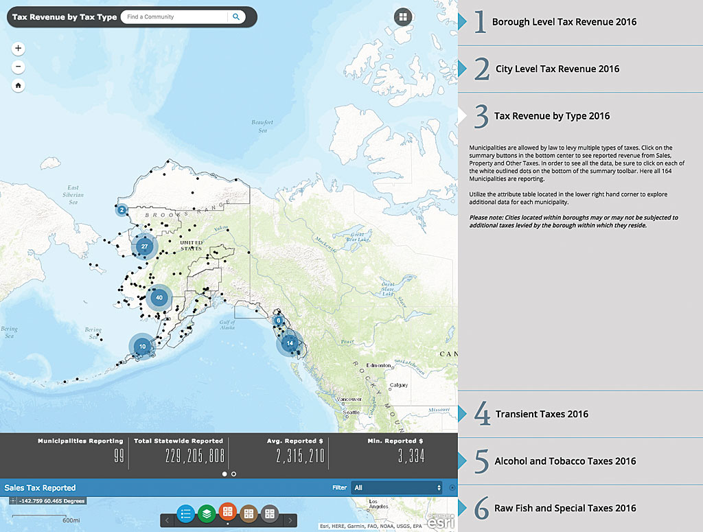
By exploring its 12 pages, users learn about tax law, tax rates for each municipality, reported revenues, the breakdown for property tax revenue, tax exemptions both current and historic, the value for all real and personal property regardless of exemptions, and historic real property values. An animation shows how the exemption amounts have changed over time. A dashboard shows the number of municipalities reporting, total revenue, average revenue, and minimum reported revenue.
Quick tips strategically placed throughout the map’s pages help users locate information using the tools provided. Pop-ups make detailed information for each municipality easy to access by displaying charts of revenue breakdowns, historical real property values, and links to community fact sheets detailing municipal-specific taxation.
Getting Tax Information to More People
The traditional audience for Alaska Taxable has been the legislature. The information it contains is critical to carrying out its work. The Alaska Taxable 2016 story map immediately captivated people both inside and outside of state government.
“Legislative staff, the Department of Health and Human Services, the Department of Natural Resources, and even out-of-state businesses thinking about locating in Alaska have found the story map extremely helpful. The story map is now an essential part of the Alaska Taxable publications we provide to the legislature every year before they go into session,” said Brown.
Alaska Taxable in story map form is more readily used by state government staff, businesses, and the public. As Alaska enters its second year of recession, the topic of revenue generation has much broader interest. Local research groups like the Institute for Social and Economic Research have found the story map to be “an excellent resource” as they prepare reports examining the vulnerability of municipalities to reductions in state aid. Local government specialists use the map when discussing the possibility of tax rate increases with communities. Specialists can easily access OSA data and compare a community’s current revenues with those of other communities of similar size. By showing how local governments fund themselves, Alaska Taxable can inform larger conversations.
Although the business community had used the printed version, they have been impressed with the story map version because it lets them look up municipal property taxes and sales taxes statewide easily. Tax codes for each community are unique, so being able to look up the individual tax rates and exemptions for each of Alaska’s municipalities is a huge benefit for businesses. It is also a great savings in time for OSA staff members who previously had to spend significant time marshalling tax information for business requests. For the same reason, the story map saves OSA time when fulfilling information requests from the public.
Improving the Process
The success of the Alaska Taxable 2016 story map has guaranteed a version of it for 2017. The team continues to come up with new ways of streamlining the workflow used to produce it. As it becomes more widely known, its value as a decision-making tool should grow.
The adoption of Survey123 for ArcGIS to collect data and its publication as an Esri Story Maps app accomplished the team’s goals of documenting and simplifying the process of generating Alaska Taxable each year. In the future, Excel will have a minor role in containing and maintaining tax data as all data—current and past—is migrated to a single file geodatabase that can be queried against other community-level data.
Although the primary role of that data will be the production of Alaska Taxable, it will also be used by the state assessor for other purposes. Because the data is available as a feature service, others in state government can use it for their research. Other departments are interested not only in the data but in using Esri Story Maps apps as an effective communication tool. The Department of Health and Human Service is interested in creating a story map for its directory of health care facilities.
“Certain accounting functions and regressive modeling that require tax data are performed by staff, and Excel will be the medium of choice for that. But in terms of storage and maintenance, Excel will no longer be the primary tool,” said Beaujean.
As more functionality is introduced into Survey123 for ArcGIS to make the process more efficient, the team continues to refine the surveys. “Our hope is to one day have a complete and robust survey available for all municipalities to access online and filled by qualified staff,” said Brown. This will eliminate the need for data entry by OSA. Providing functionality that gives municipalities access to previous years’ survey data will give them a ready reference and eliminate the need for rummaging through old—often paper—files.
The team has an even more ambitious vision to get all future and past Alaska Taxable data into the geodatabase as well so that time series and predictive analyses can be performed.
In Summary
The team members appreciated what they were able to accomplish as novices and see great potential in how Alaska Taxable 2016 can expand and benefit the state.
Boyina summarized the project by saying, “The experience of designing and developing the workflow exposed the team to how three different tools in the Esri platform can be seamlessly weaved together. ArcGIS Online hosted the Alaska tax story that was compiled using feature services published from data edited in ArcMap and captured in Survey123. Our experiment, carried out with the hard work, dedication and patience of the team, was a success!”
She was appreciative of the support of all on the management team by saying that “none of this would have been possible without the support of the DCRA management team and the DCCED Commissioner’s Office.”


