"This new process has increased our response time drastically. Field employees can now see where they need to go, and tickets can be dispatched throughout the day without the employee going back to the office."
case study
GIS Improves and Speeds 811 Ticket Fulfillment Process
Industry—Electric and Gas
Mountaineer Gas Company delivers natural gas to approximately 220,000 customers in 51 of 55 West Virginia counties through a pipe network over 6,000 miles long.
Challenge
Improve the inefficient legacy 811 response process that was based on email, printed paper tickets, and manual hand-offs between office and field staff.
Solution
A modernized process enabled by ArcGIS Online and ArcGIS Enterprise supports real-time collaboration among all involved staff with all-digital documentation accessible in the office and field. Mobile apps that field workers could use such as ArcGIS Survey123 and ArcGIS Field Maps connect them to office staff who are using ArcGIS Workforce, ArcGIS GeoEvent Server, and ArcGIS Dashboards.
Result
Overall, the GIS-based 811 process at Mountaineer achieved all the utility’s goals. The end-to-end user experience is improved across the board. The new solution also enabled real-time collaboration during all stages of the process across the utility. All-digital documentation and reporting enhanced records and enabled positive response back to WV811 on tickets worked. Time and resources spent on locating were cut down as a result of the implementation of GIS tools.
Mountaineer Gas Company delivers natural gas to approximately 220,000 customers in 51 of 55 West Virginia counties through a pipe network over 6,000 miles long. Various private entities consistently perform underground work around Mountaineer’s assets, and individuals planning this work, such as excavations, demolitions, or other earth-disturbing activity, must notify WV811—the statewide one-call system—of their intentions. WV811 then provides this information to utilities and other entities so they can mark the location of their underground assets in the planned work area for safety purposes. These notifications are referred to as tickets, and in 2022, Mountaineer received more than 55,000 such tickets from WV811.
For years, Mountaineer Gas worked these tickets using a legacy process. Field workers had to work from printed communications and reports received through a network of multiple email boxes. Utility staff knew they had to modernize their 811 processes, so they implemented geographic information system (GIS) technology. The new all-digital process improved dispatch accuracy, service quality, general and emergency response times, collaboration, and more.
Challenge
The company’s legacy workflow had significant room for improvement. Excavators would create dig tickets in WV811’s GeoCall system that would then be sent electronically to shared email mailboxes where dispatchers throughout West Virginia would access them. A dispatcher would print the email and then distribute this ticket, physically or by fax, to a field worker for completion. The manual, paper-based process required field workers to input an address or GPS coordinates which resulted in unnecessary time spent simply determining the ticket location. Upon completion of the work, a paper copy would be stored in a physical filing system at the respective service center location. On top of that, this legacy process did not involve informing WV811 or the excavator that the work had been completed. This left a level of uncertainty for the excavator if locating had truly taken place, leading to wasted time, money, and resources for all parties involved.
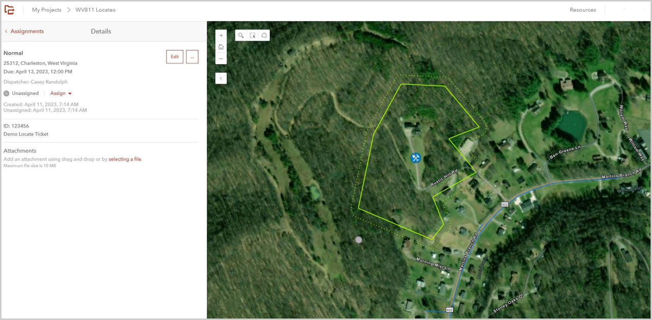
 Overhead view of WV811 Locates
Solution
Mountaineer committed to a modernized solution enabled by ArcGIS Online and ArcGIS Enterprise that met the utility’s goals. These goals included eliminating email as the means of 811 ticket communication, responding to emergency tickets in a timelier fashion, increasing the accuracy of dispatching field workers, and improving efficiency by not having to print and work from physical tickets. Other goals included improving reporting by using digital copies of all tickets and responses, communicating with WV811 in real time about positive responses on tickets, and creating a solution with Esri mobile apps currently being used by Mountaineer field workers.
Tickets received from WV811 are created in an ArcGIS geodatabase accessible to all involved Mountaineer staff. By using a dashboard, dispatchers can readily see the number and status of all tickets, sort the tickets by area and type, select a ticket, highlight it on the map, and assign it to a worker in that area. The field worker assigned to the ticket can then open it on their smart device using a mobile app, get directions to its location, complete a survey detailing the work performed, and provide confirmation of completion of the assignment.
 Facility Locate ticket
Results
Overall, the GIS-based 811 process at Mountaineer has been extremely successful. The end-to-end user experience was improved across the board, and the new process has enabled real-time collaboration and reporting on all tickets and responses. The need for physical copies of tickets was eliminated, improving the timeliness and accuracy of dispatching and reporting and cutting down the utility’s response time on emergency tickets. The modernized system allowed Mountaineer Gas to provide positive responses to WV811 on all tickets worked.