Essential workers are risking their lives every day. The least we can do is help them to easily find childcare.
user story
Washington State Helps Essential Workers Locate Childcare Facilities
While many parents are now juggling remote work and their children's remote learning—on top of adjusting to the daily realities of quarantine during the coronavirus disease 2019 (COVID-19) pandemic—a significant number of essential workers must still report to work each day, and often they struggle to find childcare.
Health-care professionals, first responders, grocery store workers, public service employees, gas station attendants, bankers, and others considered essential are already taking a health risk to be at work. For those with children, the situation is more challenging as schools and most childcare facilities are currently closed.
In Washington, one of the US states hardest hit by COVID-19, the governor's office mandated that schools provide childcare for essential workers. However, not every school is participating, so it's difficult for parents to find which facilities are open.
Staff at the state's Washington Technology Solutions' Office of the Chief Information Officer (OCIO) saw this disconnect and wanted to help.
"Essential workers are risking their lives every day," said Joanne Markert, geographic information systems coordinator for the OCIO. "The least we can do is help them to easily find childcare."
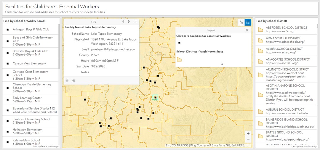
Markert and the geospatial team created an online, map-based dashboard to show which facilities are open for childcare. Essential workers can use the interactive dashboard to select a school district and quickly see available facilities. They can also click on the individual facility to learn more details such as the name, address, email and/or phone contact information, county location, and hours.
 The Washington state public dashboard uses GIS to enable essential workers to find the childcare facilities they need.
Building the interactive map took collaboration across agencies and the use of geographic information system (GIS) technology from Esri. The team at OCIO used ArcGIS Dashboards from Esri to create the interactive map. Staff at the Office of the Superintendent of Public Instruction provided the underlying GIS data on schools and school districts. The State Emergency Operations Center provided additional information about hours of operation, specific email addresses or phone numbers to contact, and alternative sites such as Boys & Girls Clubs working in partnership with the schools.
The public can access the dashboard on the Washington Geospatial Open Data Portal at geo.wa.gov. As with everything during these unpredictable times, the facilities and their availability are constantly changing, so the dashboard provides workers one authoritative place for the most current status updates.
"We hope that this dashboard alleviates a bit of stress for these folks during such a traumatic time," said Markert.
In Support of Esri ArcGIS Users
The story of Washington state is just one example of how organizations are using GIS to respond to and operate more effectively during the COVID-19 crisis. This effort can be replicated in communities across the globe.
Esri is dedicated to supporting the efforts of many organizations through software, technical support, and resources. Some examples include the following:
• The Esri COVID-19 site connects organizations with insights, information, and updates.
• The COVID-19 GIS Hub provides a definitive resource for data, solutions, FAQs, and best practices to help organizations get started.
• The Esri Disaster Response Program (DRP) assists organizations with GIS software needs, technical support, services, and data. For immediate assistance, submit a Request for Assistance form. Requests are monitored 24/7.
As GIS technology continues to support organizations worldwide through this crisis, Esri will gather best practices and share lessons learned from jurisdictions around the globe to provide a greater understanding of and inspiration for COVID-19 response efforts.