Data management
Create raster and vector GIS representations of the landscape and built environments for water resource analyses.

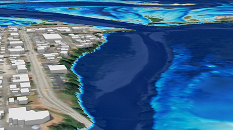
GIS for water resources

Water resource managers use GIS technology to visualize and analyze topographic, hydrographic, and hydrologic data for tasks such as assessing water quality, estimating water availability, planning flood prevention, understanding the natural environment, and managing water resources.
Esri's Arc Hydro consists of a data model, toolset, and workflows developed over the years to support specific GIS implementations in water resources. It operates on both ArcGIS 10.x and ArcGIS Pro, offering the latest in innovation in GIS to help you create a deeper understanding of your hydro data. Arc Hydro helps you build a foundational dataset that can be used in water resource analyses and for integration with water resource models. It standardizes water data structures so that data can be used consistently and efficiently to solve a wider range of water resource problems at any scale—regional, national, or international.
Create raster and vector GIS representations of the landscape and built environments for water resource analyses.
Integrate raster, vector, tabular, and network data into an efficient and consistent modeling foundation that is easy to extend and configure for specific GIS implementations.
Identify sinks; determine flow direction; calculate flow accumulation; and delineate and characterize watersheds, stream networks, and floodplains.

Downloading and Installing Arc Hydro Tools

Arc Hydro: Resources and Documentation

Getting Started with Arc Hydro

Esri Community: Water resources and Arc Hydro

Arc Hydro: Transitioning from ArcMap to ArcGIS Pro

Arc Hydro: Project Development Best Practices

ArcGIS Pro project startup best practices

Overview of terrain preprocessing workflows
Explore innovative features for simulating floods within ArcGIS Pro, including theoretical and engineering aspects, the new simulation layer, use cases, and future enhancements.

Discover hydrologic and hydraulic capabilities in ArcGIS Pro. Industry experts share recent tools and workflows, including the use of artificial intelligence and machine learning.

Learn from Esri hydro experts in our webinar series on Arc Hydro, its principles, and its use in water resources, including watershed and floodplain characterization and modeling as well as hydrologic and hydraulic modeling.

Access this webinar series to learn about what Arc Hydro is and explore its capabilities. Our water resource experts will also present the approaches of learning Arc Hydro (instructor led and self-paced no cost learning option).