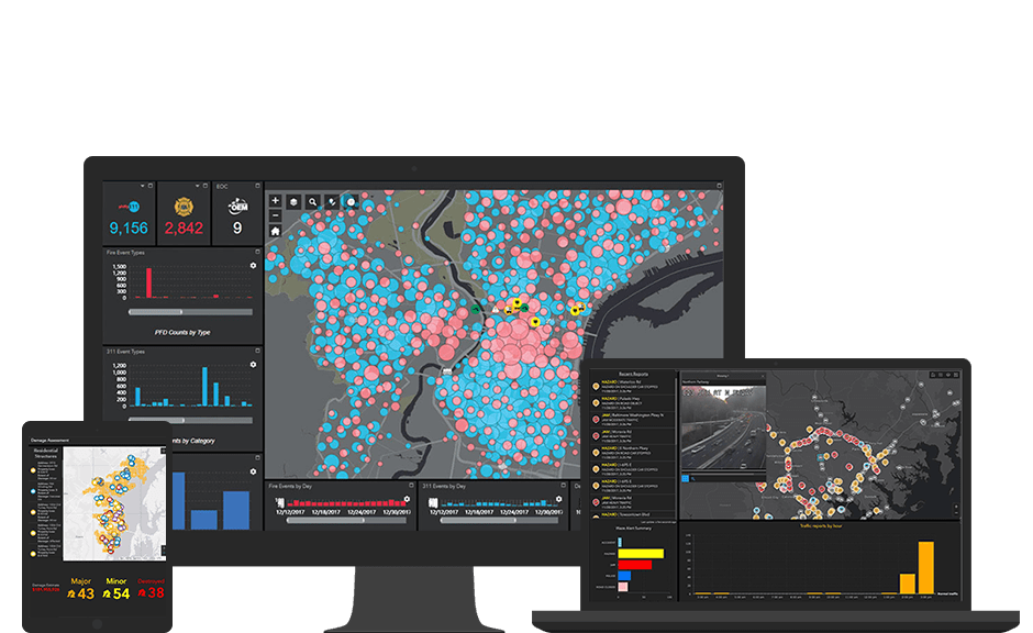
We have to remember that GIS is not [only] mapping. That’s just a piece of it. It’s the data inputs and the outputs, and the coordination that takes place on the backend that paints the picture and helps us with our decision process.
Make better decisions the moment something happens
Real-time GIS and situational awareness give you the ability to simultaneously integrate, analyze, and display streaming data from many sensors, devices, and social media feeds. You can define filters and location-based analytics that automatically refine and focus real-time data to accomplish the mission with up-to-the-minute intelligence on what's happening in the field, across jurisdictions. That's why police, fire, and emergency management organizations at all levels of government utilize Esri's real-time GIS capabilities in their operations and dispatching centers.
Getting the location of a moving object is one thing but tracking entire fleets of vehicles, vessels, or aircraft in real time allows moment-by-moment decision-making for improved operational awareness. Ports, airports, transportation companies, and government agencies all use Esri's real-time GIS technology and optimize resources.
GIS now gives you the power to analyze locations and connections to social activities in real time. With real-time data integration, searching and streaming works across multiple platforms, including social feeds, geolocated Tweets, photos, and videos, and can be viewed within the context of digital imagery, street networks, topography, and community basemaps. The data can then be layered for additional context with other information such as public safety assets, city infrastructure, utility networks, hazardous materials, and demographic data.
When an event of interest happens, maps and databases are automatically updated, and stakeholders are simultaneously alerted. You can also quickly integrate your historical operational data with your infrastructure data to discover trends, patterns, and outliers. Seeing your data in real time not only allows you to make more informed decisions but also helps your organization turn those decisions into action.
We have to remember that GIS is not [only] mapping. That’s just a piece of it. It’s the data inputs and the outputs, and the coordination that takes place on the backend that paints the picture and helps us with our decision process.
Case Study
As one of the largest disaster recovery organizations in the world, the American Red Cross responds to an emergency every eight minutes.
Case Study
Each spring, on the first Saturday in May, equestrians and fans gather for the Virginia Gold Cup steeplechase horse race. This event sits atop the social calendar in Virginia’s horse country—the epicenter of the nation’s horse and hunt community.
Case Study
In light of the recent mass shooting, the Chicago Police Department increased its presence, alongside a heightened presence from the Federal Bureau of Investigation (FBI), the Federal Emergency Management Agency (FEMA), the Department of Homeland Security (DHS), the Illinois State Police (ISP), and other agencies and nonprofits. The city of Chicago continues to increase its use of GIS to manage major special events.
Case Study
The NCAA Final Four weekend in San Antonio included a three-day music festival at Hemisfair Plaza, a fan fest at the Henry B. Gonzalez Convention Center, and games at the Alamodome. With all event venues within walking distance of each other, hundreds of thousands of people milled around the city’s compact downtown. San Antonio deployed a large force of on-foot officers to ensure safety.
We’d like to help. Fill out the form below to discuss what you need to get started with real-time situational awareness.