In the fall semester of 2020, the University of Wisconsin-Madison Department of Planning and Landscape Architecture Planning (DPLA) workshop course partnered with the Fondy Farmers Market to study the Fond Du Lac and North Area in Milwaukee, Wisconsin. The course sought to explore the potential transformation of the farmers market as a new urban anchor through planning and design visioning. The visioning strategies have the potential to inform the Fond Du Lac and North Area Comprehensive Plan Update currently underway, which is led by the City of Milwaukee Department of City Development and local community non-profits in the area.
The core purpose of the planning workshop is to serve as an intensive and applied research exercise where students apply skills learned in previous semesters to a real-world planning problem in an urban setting. This year’s workshop focused on addressing a holistic approach to planning and design in the 21st century city through the lens of social justice. Typically, a workshop project represents a real-world, real- time, policy-relevant planning exercise that will have an impact on a wide array of local activities such as economic development, transportation planning, and recreational facilities planning.
The workshop emphasizes the interdisciplinary character of planning practice and provides students an opportunity to apply socioeconomic analysis, physical planning, and implementation techniques while working with a client and community stakeholders on live community-based project. This semester’s DPLA workshop was the first in the nascent history of the recently merged department to combine graduate students in planning and undergraduate landscape architecture students. The subject matter of this workshop is a live project for a historically underrepresented neighborhood in the city of Milwaukee. The project site context includes the historic Fondy Farmers Market, the recently established Fondy Park, vacant sites, historic fabric, a major transit corridor, and green infrastructure.
Impact of the Pandemic
A key learning outcome of the Workshop is the integration of community engagement through partnerships. Equitable Community Engagement is the practice of using multiple strategies to provide opportunities for all stakeholders – particularly those historically excluded, underrepresented, or under-resourced – to be informed and participate in public planning and decision-making for equitable results. The novel coronavirus disease 2019 (COVID-19) pandemic has changed the way that engagement can take place. While engaging with communities and larger populations during the pandemic, it is important to understand the needs of specific groups who might experience barriers in accessing information, care, and support, or be at higher risk of exposure and secondary impacts. This may include children and adults with disabilities, who make up an estimated 15 percent of the population. To address the challenges of engagement due to the global pandemic, the Workshop has adapted in several ways.
Virtual Learning
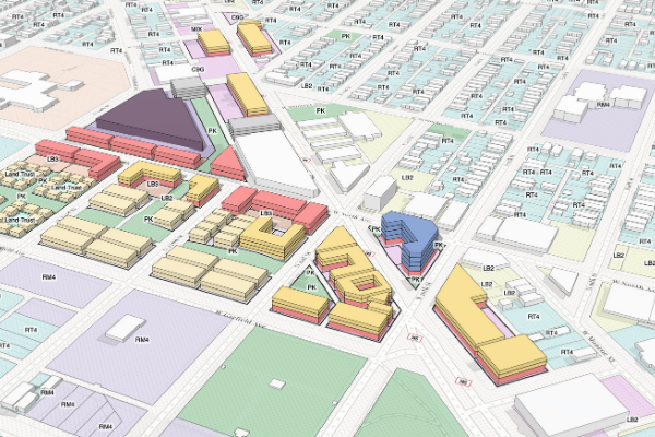
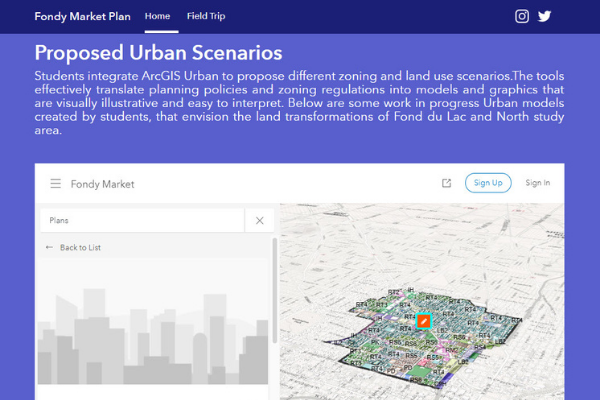
The course first had to shift to a predominately virtual teaching modality, which impacted students’ ability to collaborate in teams remotely. To address this challenge, the workshop partnered with Esri’s Smart Cities team to integrate ArcGIS Urban as a platform to facilitate simultaneous collaboration. ArcGIS Urban offers students time saving tools by streamlining the creation and sharing of development scenarios that integrate zoning and land use plans.
ArcGIS Urban has provided the workshop the ability to collaborate simulating a real-word planning environment in the context the Fund du Lac and the North Area of Milwaukee. The tool allows students to visualize in real time what a change to the zoning code would mean for building forms as well as generate quick output of development metrics that facilitate quantifying impact.
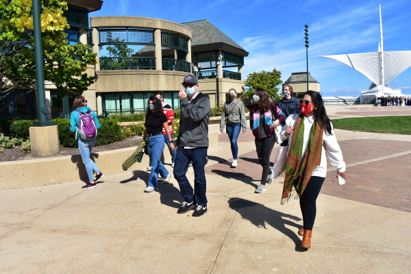
Next, the course redefined their fieldwork methodology to ensure social distance guidelines were enforced. The workshop was able to travel to Milwaukee in mid-September to carry out a comprehensive site survey and fieldwork documentation. Additionally, they met with community partners at the market. Attendees followed the COVID-19 safety protocol enforced by Fondy Farmers Market, which included social distancing and wearing facemasks at all times. Students relied heavily on windshield surveys and site observations as part of the documentation process.
Finally, community engagement had to shift to digital platforms. The workshop was not able to host large events like public meetings and focus groups. Instead, it relied on local knowledge and community feedback previously collected by the City of Milwaukee Department of City Development and the Fondy Farmers Market. Students had an opportunity to present their initial schematic designs in a virtual public meeting to receive feedback from key stakeholders in October 2020.
Documenting Research using ArcGIS Hub
ArcGIS Hub was used to document how the research and design process for the workshop evolved over the course of one semester. Students of the workshop created this ArcGIS Hub site to include up-to-date information of our ongoing virtual review process, information on public presentations, publicly published plans, and general information of the project and about our community partners. Visitors to the site can navigate and virtually explore the 3D scenario plans made using ArcGIS Urban. Much like a website, ArcGIS Hub allows site managers to add multiple pages, or subpages, and we used that feature to add pictures and summaries of our fieldwork.
A New Vision
Virtual evaluation and engagement from the public and professionals will allow students to approach city planning in a non-traditional classroom format, while responding to the challenges brought on by the COVID-19 pandemic. Building off the fieldwork and the community input, five interdisciplinary teams continue to work to establish design values, explore scenarios of potential future outcomes, and develop a preferred plan and design that meets their goals. Final visioning plans will be presented virtually via Zoom in December 2020.
Stay updated on social media:
- Esri GIS Education: @GISEd
- UW Department of Planning and Landscape Architecture: @UWisconsinDPLA
- UW Department of Planning and Landscape Architecture: @Border_Studio
- UW Landscape Architecture Student Group: @uwmadison_asla
- Fondy Farmers Market: @FondyMarket
- City of Milwaukee Department of City Development: @cityofmilwaukee
Learn more about using ArcGIS Urban resources in higher education.
