The integration of GIS and Artificial Intelligence (AI) is giving rise to a powerful field known as GeoAI. This innovation is rapidly transforming urban and community planning by providing advanced tools and techniques that automate routine tasks and make GIS functionalities accessible to a broader audience. In particular, this includes planning professionals with little or no GIS experience. The synergy of geography and AI offers planners unprecedented capabilities in analyzing spatial data, predicting community trends, and enhancing decision-making processes.
GeoAI is in the early stages of revolutionizing the way urban and community planners approach their work by automating common tasks that were once time-consuming, labor-intensive, and/or involved a level of knowledge of GIS functionality that was not there. In other words, GeoAI is transforming the way that planners can extract meaning from complex data. This empowers them to address the challenges facing them with an unprecedented data-driven approach. AI algorithms can process vast amounts of spatial data, identify patterns, and generate insights much faster than traditional methods. This automation not only saves time but also reduces the potential for human error, leading to more accurate and reliable outcomes.
Planners Have Questions. GIS Has Answers.
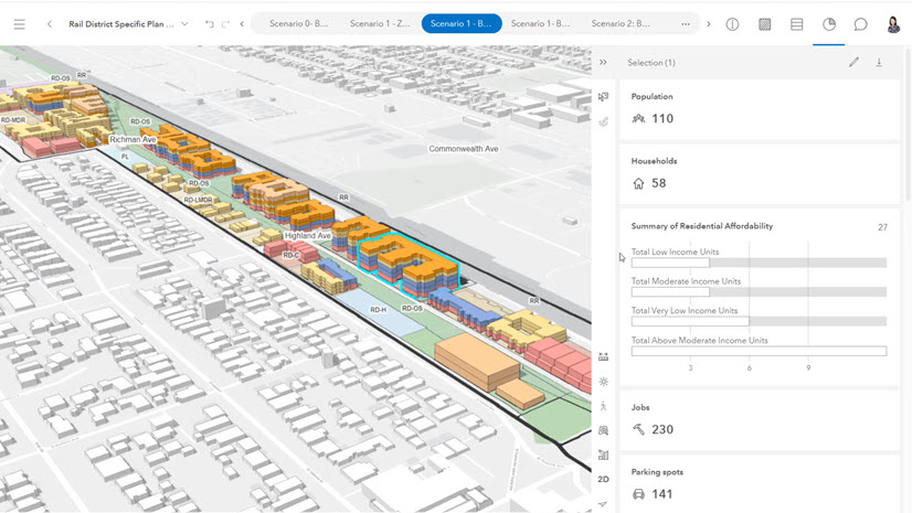
At its core, GIS finds answers to questions. Yes, usually the output is a map, but the purpose of the map is to answer one or more questions. One of the significant advantages of GeoAI is its ability to democratize access to GIS data and functionality. Traditionally, GIS tools required specialized knowledge and expertise, limiting their use to professionals with specific training. However, with the advent of GeoAI, even non-GIS professionals can leverage these powerful tools. Consider the immense amount of spatial and tabular data in cities and counties today. It is fair to assume that planners will not even be aware of everything available at their disposal.
In this instance, let’s assume I am a planner in Washington, D.C., and I need to know how many trees are along H Street. That data is available in the vast repository of data compiled by the GIS team. There is probably a map that has been curated already. Maybe there is even an app that has a tool that will let me create a buffer to find the answer. What is important, though, is that the question gets answered quickly…regardless of my GIS or data knowledge.
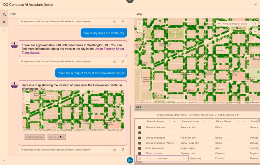
GeoAI allows me to use a prompt, essentially asking a question or making a request, for the agents, the data repositories held in ArcGIS Hub, to get this question answered. The agents contain the data, and once found, the query and analysis are run. GeoAI answers the question and creates the map for me using authoritative data for D.C. only. I don’t have to learn how to use the GIS tools. I don’t have to know where the data is located within the Open Data site. Finally, I don’t have to wait on a GIS technician to have time to perform this simple task. The question is correctly answered, and I can move forward to my next task.
GeoAI is a Principle of Planning
This is a simple, but effective example. Think about the more complex uses of GeoAI with the planning department. Show me the surrounding land use around vacant buildings in a certain neighborhood. Highlight intersections with the highest concentration of pedestrian accidents over the last five years. Find the best location for a neighborhood farmers market based on certain location parameters. The list could go on forever. The key is that, as it continues to evolve, GeoAI will empower planners in a new way to access the data and generate the analysis in order to do their job.
The future of urban and community planning is undoubtedly intertwined with the continued development of GeoAI. As AI technologies evolve and more data becomes available, the potential applications of GeoAI will expand. Urban planners will be able to design smarter, more sustainable cities that can adapt to the needs of their inhabitants. The combination of AI’s predictive capabilities and GIS’s spatial analysis will enable more proactive planning, leading to communities that are better prepared for the challenges of the future. GeoAI stands as a key innovation, guiding the way towards more efficient and intelligent urban and community planning.