Last year, the COVID‐19 pandemic forced many water utilities to close their offices and send staff home. Over the past year, utilities have made changes to meet the challenges of a remote workforce. Schedules have been modified, teams have been split up (social distancing), and new technology has been implemented. Keeping everyone healthy while continuing to serve clean, safe water has been a priority.
Digital Technology Supports COVID-19 Response
Technology played an important role in implementing these changes. An increased need for digital solutions pushed utilities to learn more about how they could continue to work while keeping staff safe. The Esri water team supported many utilities by answering questions about how GIS could help. Organizations already using ArcGIS adapted quickly, while those new to Esri had to learn a lot. In both cases, maps, applications, and dashboards enabled communication and collaboration across the distance created by COVID-19.

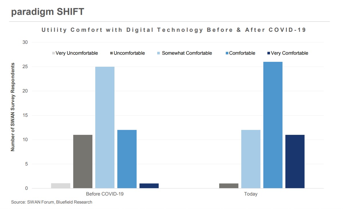
Many utilities learned how to work untethered to an office and still collaborate with their teams and others. They learned how to share data, track where people are working, and interact digitally with customers. Digital solutions have transformed organizations in a way that going back to the status quo is just not an option. Water industry professionals have discovered that technology is easier to implement and less expensive than they might have thought. In addition, they have learned that digital solutions can be deployed in an agile manner, very quickly providing support to those that need it. COVID-19 has pushed utilities to digitally transform, and they have experienced an increase in effective and efficient work resulting in permanent change.
Leveraging ArcGIS for Success
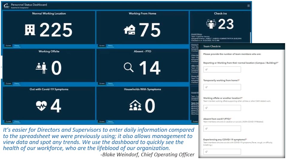
Central Arkansas Water (CAW) is a utility that put GIS to work during the pandemic. But GIS was not its first step. The utility put together a pandemic response team to help navigate through day-to-day operations. This team was in charge of making decisions on supplies like hand sanitizers, face masks, and workspace cleaning. Alex Harper, GIS manager, was part of this response team and helped the utility implement several new workflows in response to the challenges. Learn how CAW used GIS to provide tools that streamlined workflows and kept everyone informed by watching this short presentation from Harper: Maps & Apps Support COVID-19 Response at Central Arkansas Water.

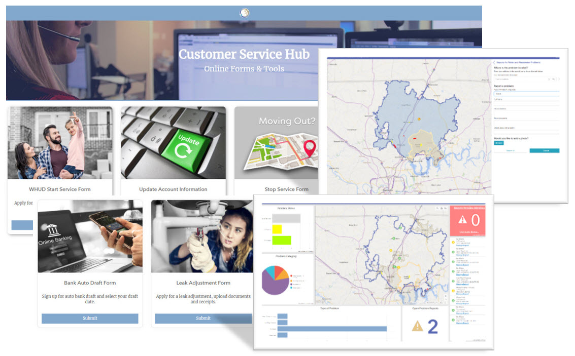
White House Utility District (WHUD) closed its lobby to customers during the pandemic. WHUD adopted various new practices to help customers who were financially burdened by the pandemic and also encourage all to use phone and online payment options. The goals of implementing these new practices and many other changes were simple: to help reduce the spread of the virus and to protect employees and customers. Read WHUD’s story to learn how it has not just maintained service to its customers but has also improved the way it serves and interacts with its customers: Harnessing the Power of GIS to Improve Customer Service.

Central Arkansas Water and White House Utility District took advantage of their existing ArcGIS system to quickly implement solutions that made a big difference during the COVID-19 pandemic. Whether you’re an established Esri customer or just getting started, ArcGIS has products and solutions that can be implemented quickly to help you face today’s challenges. My colleague Dave Wachal sat down with WaterWorld’s Alanna Maya recently to discuss how the pandemic has impacted water utilities and how Esri technology is helping them respond. Watch the interview: Digital Lessons Learned in 2020.
A Strong Community
I’ve always enjoyed working in the water industry because of the community. Whether you’re just getting started or working to implement a new solution, there is always someone willing to help!
When asked, our utility customers gave these suggestions for those just getting started:
- Identify a couple of quick wins that will help staff understand the potential of new solutions, then expand from there.
- Be okay with some uncertainty. Understand the importance of working through the problem—you don’t have to solve it all at once.
- Configure first. Take advantage of what you have. Understand what your system will and won’t be able to do. Out-of-the-box applications and solutions will do 80–90 percent of what you need.
- Find someone passionate about getting the job done. Plans, strategies, and technology only take you so far. Every organization needs someone to take a project over the finish line and make it successful. It’s people that make a difference.
If you need support, please reach out to Esri’s water team at water@esri.com.
We are here to help.


