Geographic information system (GIS) technology, a foundational security platform increasingly adopted by port communities, unifies various mission requirements and operationalizes information to secure our Maritime Transportation System (MTS). Its integration empowers ports to streamline operations and enhance real-time, actionable decision-making, effectively addressing diverse security challenges and instilling confidence in the port’s safety for personnel, stakeholders, and the greater maritime community.
Ports bring together all intermodal transportation methods, establishing pivotal hubs in global trade and transportation networks and serving as the backbone of a secure homeland. The fundamental role of ports in facilitating international commerce makes them strategically vital yet inherently vulnerable. The magnitude and variety of goods and passengers passing through ports amplify these vulnerabilities, making ports attractive targets for terrorism, criminal activities, and economic disruption. This underscores the urgent need for robust security measures, as the potential risks are significant, and the consequences could be catastrophic.
The United States Navy is the largest in the world and a crucial part of national defense. Ports serve as home bases for the Navy fleet and support personnel, providing logistical support for global deployments. Public use of ports, including parks, restaurants, hotels, and water recreation, complicates security. Additionally, commercial activities like cruise lines, fishing, and offshore operations add to the ports’ diverse functions.
Dave Foster, Homeland Security Manager
San Diego Unified Port District
Port of San Diego Harbor Police
The intricate web of interconnectivity in global maritime activities heightens ports’ exposure to international threats while introducing localized security risks. These dual vulnerabilities necessitate dynamic security measures to safeguard against foreseeable and emergent threats. Immediate and effective action is essential to prevent potential security breaches and ensure the safety of global port and maritime operations.
For ports, establishing a heightened and connected Maritime Domain Awareness (MDA) is not just important; it’s critical. This is because the port community faces a variety of shared threats, including these:
- Terrorism and sabotage: attacks aimed at causing widespread damage or disruption to port operations.
- Smuggling of drugs and other goods: illegal movement of drugs and goods through ports, often hidden within legitimate cargo.
- Human trafficking: the use of ports as transit hubs, where traffickers exploit complex operations to smuggle victims across borders.
- Supply chain security: threats to the supply chain that disrupt the smooth delivery of essential goods and services.
- Theft: the pilferage of cargo from ships, containers, and storage areas.
- Cyber-attacks: threats targeting operational technology and information systems that manage port operations.
- Illegal fishing and poaching: activities that may not directly target port infrastructure but affect the surrounding marine environment and resources.
- Accidents and environmental hazards: spills and other industrial accidents that can significantly damage port infrastructure and the environment.
- Natural disasters: events such as hurricanes, tsunamis, or earthquakes that can severely disrupt port operations and cause extensive damage.
ArcGIS for Port Security and Maritime Domain Awareness

Implementing an effective GIS platform is crucial in improving port security and Maritime Domain Awareness. The Maritime Transportation System faces increasingly complex threats, and ArcGIS provides an essential framework of tools designed to mitigate these challenges. It enhances port security and stabilizes maritime networks by integrating, operationalizing, and unifying people, processes, and data into a cohesive strategy.
ArcGIS enhances information collection, analysis, dissemination, and sharing. It strengthens security protocols and boosts port operational efficiency through the following features and functionalities:
Data Acquisition and Management
The global GIS data ecosystem is vast and continually expanding, with new users and information sources added daily. Data acquisition for port security involves gathering information from diverse sources to ensure comprehensive monitoring and effective risk management. Integrating data from business, crime, and intelligence records, whether they are public or private, is essential for developing a robust security framework. Geographic information systems play a pivotal role in data management, offering powerful tools for collecting, storing, organizing, and retrieving spatial data.
Port Surveillance and Monitoring

ArcGIS can integrate data from radar, cameras, Automatic Identification Systems (AIS), automatic vehicle locating (AVL) technology, and other sensors to provide real-time tracking for enhanced situational awareness. This helps monitor water- and land-based movements within and around the port area, detect unauthorized or suspicious activities, and respond quickly to potential threats.
Below are additional examples of tradecraft and related techniques that establish a repeatable pattern to support surveillance and monitoring activities:
- Real-time data integration and visualization: ArcGIS can integrate and visualize real-time data from various digital sources of information and sensors. This provides a comprehensive view of all maritime and port activities on a single interface, enabling security personnel to have a more complete awareness of their area of responsibility (AOR).
- Geofencing and proximity analysis: ArcGIS allows for the creation of geofences—virtual perimeters for real-world geographic areas. By setting up geofences around sensitive or restricted areas within the port AOR, ArcGIS can alert personnel when a trackable conveyance (ship or car) enters or leaves these zones, helping enforce security protocols and quickly respond to potential breaches.
- Event detection and alerts: Through complex event processing, ArcGIS can be configured to automatically detect multi-modal patterns of behavior based on predefined criteria, such as dwell time, loitering, rapid changes in course or speed, and proximity to restricted areas. The system can trigger alerts to port authorities, prompting immediate investigation or action.
Real-Time Threat Management

Integrating GIS with real-time threat feeds and alerting capabilities can significantly enhance situational awareness and event management at ports. This includes preventing or reducing the impact of critical incidents, decreasing response times, and supporting informed decision-making. By aggregating data from social media, news outlets, E911 systems, weather feeds, intelligence information, and cyber sensors, port organizations can conduct advanced spatial analysis and data fusion and visualize complex threat environments more clearly.
Esri’s real-time data engines facilitate incorporating streaming information feeds into operational workflows. These tools enable continuous incident detection, real-time analytics, user-defined filtering, alerting, and response protocols ensuring timely and informed responses to dynamic situations.
Below are examples of several common workflows:
- Data fusion: GIS can integrate and evaluate data from multiple sources, including CAD/record management systems, social media feeds, and internal organization data. Fusing these data feeds into one operational picture provides port security personnel with an up-to-date, comprehensive view of all potential threats that might impact the port AOR.
- Incident mapping and tracking: ArcGIS enables the mapping and tracking of threat incidents in real-time. By capturing the location, nature, and status of threats, GIS can assist in coordinating response efforts, allocating resources, and providing information to relevant stakeholders at your port.
- Prioritized monitoring: Port users can apply filters to real-time threat feeds to evaluate data more quickly and efficiently. Examples include implementing geofences around sensitive locations, filtering incidents by type and severity, and identifying hot spots where activity surges in a specific area, triggering immediate alerts.
- Threat escalation and incident triage: Effective security management includes clear protocols for escalating and reporting alerts to ensure appropriate action. GIS supports triage workflows by condensing and refining information prioritized by severity and potential impact. By adopting this approach, incidents can be efficiently tracked, managed, and resolved.
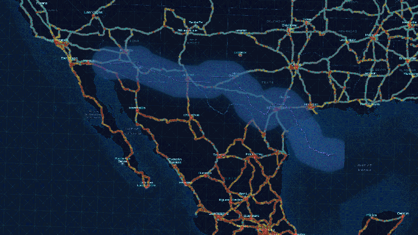
Historical Data Analysis and Trend Analysis

By collecting and analyzing spatially enabled historical data from sources including imagery, AIS, and crime and intelligence data, ArcGIS can help identify patterns and trends in vessel behavior as well as other reported suspicious activity such as onshore criminal incidents. This insight is valuable for anticipating potential security threats and planning preventive measures. For example, if a particular area has an identified pattern of illicit activities, more rigorous surveillance and patrolling can be scheduled. Similarly, dashboards can be configured to show key metrics, such as the location of active vessels, incident status, and responses to alerts, all updated in real-time.
Below are some common forms of data analysis:
- Temporal analysis: Examining changes in port activities over time, such as increases or decreases in ship traffic, variations in cargo types, and shifts in port usage patterns.
- Event mapping: Plotting historical incidents like crimes, accidents, spillages, or security breaches on a map to identify hot spots and patterns.
- Change detection: Using time-series satellite images to observe physical changes in port infrastructure or environmental conditions.
- Pattern of life: Detecting atypical patterns or deviations from routine activities, movements, and behaviors within a port AOR.
- Dwell analysis: Examining a vessel’s time in one area to identify unauthorized activities, operational inefficiencies, or security breaches.
Threat and Vulnerability Assessments

By analyzing historical data and real-time inputs, ArcGIS can help identify potential risk factors related to criminal activity, suspicious behavior, weather, traffic density, navigational hazards, and more. This information is crucial for decision-making around security planning, allowing port authorities to mitigate risks proactively.
Methods by which ArcGIS can improve a port’s risk management capabilities include:
- Security site surveys: Use comprehensive inspections to gather existing security policies, site plans, and previous assessment reports. ArcGIS enhances this process by using mobile survey tools to collect and catalog critical data points and visualize the tactical points of interest. The output clearly explains vulnerabilities, operational context, and assets requiring protection.
- The ability to understand your AOR: The geographic data ecosystem is extensive, covering various data sources from various disciplines. This includes demographics, environmental data, real-time traffic conditions, and satellite imagery. When this diverse geographic data is integrated with security-related information, it becomes an invaluable tool for addressing the complex challenges faced by our ports.
- Impact analysis: Once relevant datasets are collected and security assessments are updated, various geoprocessing tools can identify the affected population. When analyzed, the results show the impact on port operations, financial stability, critical facilities, and human safety.
Critical Event Management

Critical event management (CEM) is a strategy for addressing scenarios that significantly impact organizations, communities, or the environment. These scenarios range from large-scale planned events to unexpected crises like human-made incidents, natural disasters, or public health emergencies. ArcGIS is crucial in improving CEM, particularly in port security, where protecting vital infrastructure, supply chains, and assets is essential.
With port security, ArcGIS software-based CEM is instrumental in several ways:
- Emergency planning and preparedness: Location intelligence helps organizations develop emergency response plans and operational preparations, model scenarios, and simulate potential outcomes. Based on spatial analysis and modeling, ArcGIS helps identify vulnerable areas, evacuation routes, and resource allocation strategies.
- Resource management: ArcGIS helps manage and track resources during critical events. It can display the location, status, and availability of personnel and equipment on a map, helping in resource allocation and deployment based on proximity and need.
- Situational awareness: ArcGIS helps create situational awareness by providing a comprehensive view of the event’s location, affected areas, and relevant assets or resources. It allows users to overlay multiple data layers—such as infrastructure, population density, and transportation networks—to understand the potential impacts and create response strategies.
- Damage assessment and recovery: ArcGIS assists in response efforts, including damage assessment and recovery after an event. GIS tools can track and assess the extent of damage, prioritize recovery actions, and allocate resources effectively. These tools also help communicate recovery progress to the public and stakeholders through mobile data collection tools, interactive maps, and dashboards.
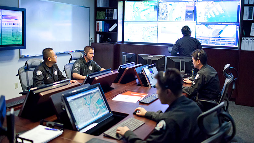
Field Operations
Securing ports and the maritime transportation system involves a broad team, including environmental, maritime operations, tenant management, and public use departments. These subject matter experts, while not security personnel, play a crucial role in developing and using ArcGIS tools for port security. Their collaboration is essential for effective design, analysis, and response.
Dave Foster, Port of San Diego Harbor Police
ArcGIS mobile tools can be pivotal in tracking multi-discipline field teams within a port environment. Mobile GIS apps enable precise monitoring of the location and movements of security and other port personnel, ensuring optimal situational awareness and coordination. This capability is crucial in dynamic port environments, where rapid response to security threats is essential. GIS allows for the visualization of team positions on detailed maps that depict port features, facilitating strategic deployment and efficient management of resources. This ensures proper command and control as well as the ability to swiftly address incidents, safeguard critical infrastructure, and maintain the overall security of the port.
- Command and control: Integrate GIS data, authoritative maps, live data streams, and real-time updates from field-based personnel and analysts in command centers for informed decision-making in critical situations
- Tactical situational awareness: Mobile and desktop GIS apps utilize critical incident mapping tools to visualize where resources and personnel are and coordinate team movement. Users can update operational maps in real-time based on updates from the field and across command centers.
- Persistent communication: Tracking apps enable teams to maintain continuous communication, allowing field teams to share location details, chat history, and reports seamlessly. This persistent communication supports collaboration among team members in the field as well as between those teams and the command center.
Interagency Collaboration, Interoperability, and Information Sharing

Proper governance and mindful development of stakeholder IT infrastructure are essential for effective information sharing. While technically possible and even easy, sharing information between local, federal, DoD, LE, and non-LE entities is not feasible without appropriate MOUs, policies, and IT design to facilitate this sharing.
Dave Foster, Port of San Diego Harbor Police
ArcGIS facilitates better coordination and information sharing among various stakeholders involved in port security, including local law enforcement, the Coast Guard, and other maritime agencies. Sharing a common operating picture enhances situational awareness and streamlines emergency response.
Whether your AOR is one port or a global network of ports, ArcGIS can transform your port security framework. Below are some examples of how:
- One platform, many missions: ArcGIS is a complete system relevant to multiple port security missions and tasks. It provides a configurable framework for managing and operationalizing information, enabling users from different security organizations to leverage its capabilities for their specific missions while eliminating the need for multiple-point solutions.
- Interoperability: Esri uses open standards, enabling seamless integration with third-party security systems and technologies. Users can engage in spatial collaboration when combined with platforms like Microsoft Teams or Slack. This interoperability allows access to additional functionality and information sources, helping organizations maximize their existing security infrastructure and technology investments while avoiding dependency on proprietary solutions.
- Cross-agency collaboration: Esri‘s use of open standards supports many collaborative features that enhance communication and coordination within agencies and across organizations. Chat, videoconferencing, and document sharing can be integrated with ArcGIS, further exploiting the value of collective impact across domains.
- Virtualized operations: Command centers must embrace virtual operations to meet the demands of a modern port. The capabilities of Web GIS provide organizations with the tools to coordinate and manage operations remotely, especially during emergencies and public health crises. Virtual operations enhance flexibility and scalability, reduce cost, extend geographic reach and communication, and improve business continuity. Through Web GIS, organizations can effectively adapt to evolving threats, optimize resource utilization, and achieve operational success, irrespective of their physical location.
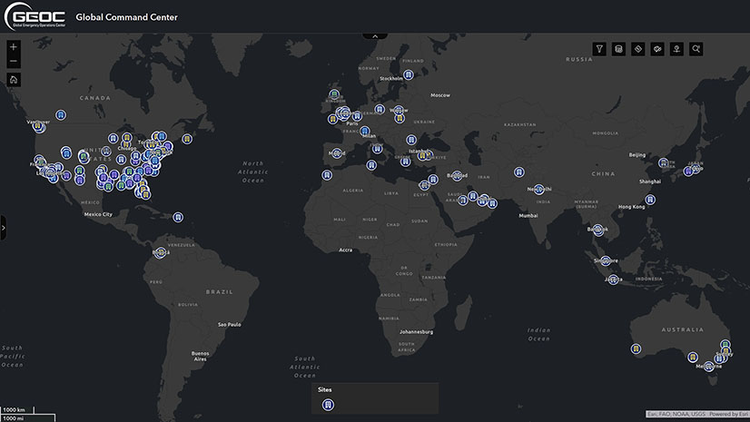
- The Esri Ecosystem: The Esri ecosystem is a global network of GIS users and organizations interconnected through software, tools, data, and mission. It facilitates smooth data sharing, encourages collaboration, and enhances skills within the GIS and security communities. This network allows users to access numerous opportunities for data sharing, collaboration, and collective problem-solving. This is especially advantageous for the homeland security enterprise, as it enables local, state, federal, and private security organizations to significantly reduce costs by collaborating and sharing their existing GIS investments. This ecosystem includes approximately 350,000 organizations and 10 million individual users.
Training and Exercises
ArcGIS can significantly enhance training and tabletop exercises using simulated scenarios that might commonly affect ports and port security. By integrating spatial data, GIS provides a dynamic and interactive platform for visualizing and analyzing geographic information relevant to the training scenario. This enables participants to better understand the spatial context of incidents, identify critical infrastructure, and assess potential impacts on the population and environment. GIS tools can simulate real-time data, allowing for testing various response strategies and their outcomes. Additionally, GIS can facilitate communication and collaboration among participants by providing a common visual reference, leading to more effective decision-making and improved preparedness. Here’s how GIS can enhance these exercises:
- Scenario visualization: GIS allows the creation of detailed, realistic maps and scenarios for tabletop exercises. This helps participants visualize the situation, including the geography, infrastructure, and potential hazards specific to the simulated area.
- Resource allocation and management: GIS can effectively manage and allocate resources during a tabletop exercise. It can display the locations of emergency services, hospitals, and evacuation routes, enabling planners to make informed decisions about where to deploy resources in response to simulated events.
- Impact analysis: GIS can model the potential impact of various scenarios, such as natural disasters, terrorist attacks, and other emergencies. This includes damage assessments as well as simulations of flooding and the spread of hazardous materials. These models help participants understand the potential severity of different scenarios and plan their responses accordingly.
- Real-time data integration: GIS in tabletop exercises can integrate real-time data feeds, such as weather conditions, traffic information, and news updates. This integration can provide a dynamic element to exercises, making them more realistic and challenging.
- Collaborative planning: GIS can help multiple agencies and stakeholders collaborate more effectively. They can access shared maps and data, which helps coordinate their responses and ensure that all parties work with the same information.
- After-action reports: GIS data can be used to review participants’ performance after an exercise. By analyzing movements, resource allocations, and decision points within the GIS, organizers can identify areas for improvement and success.
Contributing Author
Dave Foster is the Homeland Security Program Manager for the Port of San Diego. He manages the Port’s emergency management, physical security, intelligence analysis, and Port Security Grant (PSGP) funded programs, as well as coordinates security efforts with the Port of San Diego information security (INFOSEC) and maritime operations. Dave is active within the Area Maritime Security Committee (AMSC), serving on the Maritime Domain Awareness (MDA) subcommittee, as well as coordinating with the USCG Sector San Diego on homeland security-related issues. Dave also serves on the MDA subcommittee for the California Maritime Security Council (CMSC), the State of California’s equivalent of the AMSC, and served on the CMSC subcommittee updating the California State Maritime Security Strategy.