Our society stands on the brink of an unbelievable transformation, a once in a lifetime effort if you will, as we embark on the journey to expand broadband networks deeper than ever into the rural heartlands of America. This undertaking, fueled by substantial investments and the goal of achieving global connectivity, emphasizes the critical need for thorough planning, broadband deployment efforts, and ongoing network operations or maintenance. To connect society completely, the telecom industry needs a comprehensive solution.
The comprehensive solution at the forefront of this nationwide undertaking is Esri’s ArcGIS system. Augmented by the financial support of the Broadband Equity, Access, and Deployment (BEAD) program, this combination of advanced geographic information system (GIS) capabilities and significant funding creates an incredible resource for tackling the complex challenge of expanding rural telecom networks.
After spending over 20 years in the industry, I believe the importance of this broadband expansion cannot be overstated. The promise to bridge the digital divide brings cutting-edge telecommunications services to underserved communities. The strategic use of ArcGIS technology plays a central role in this process, offering a collection of resources and tools that enhance decision-making at every stage of the network expansion lifecycle. From initial analysis to the optimization of broadband deployment plans, ArcGIS equips telecom companies with the necessary insight and engagement tools needed for navigating the complex landscape of rural expansion.
In this article, I hope to build upon some of the insights I’ve previously shared, and offer a deeper dive into the operational, environmental, and human dimensions of leveraging ArcGIS in rural telecom network expansion. Through exploring each of these aspects in greater detail, I hope to highlight the comprehensive approach required for ensuring the successful completion of these vital projects. Together, I believe we can contribute to a more connected and technologically inclusive rural America.
ArcGIS in Rural Expansion
With the national goal to extend telecommunications networks deeper into rural areas, ArcGIS emerges as an indispensable system offering a comprehensive suite of capabilities purpose-made for the unique challenges of rural expansion. Its role goes beyond mere data analysis and mapping. In my experience, I believe ArcGIS acts as a strategic guide, revealing the ideal path for telecom companies to travel through the complexities of rural expansion. By converting vast amounts of raw location-based data into actionable intelligence, ArcGIS facilitates informed decision-making across all phases of broadband expansion, including planning, implementation, and maintenance.
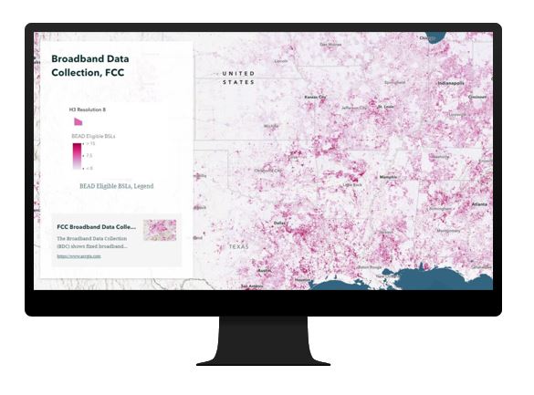
ArcGIS’s analytical capabilities allow telecom companies to visualize and assess their existing and potential network infrastructure. This visualization aids in rapidly identifying underserved areas, optimizing route planning for any network topology, and assessing any geographic present that may impact network expansion. Furthermore, its advanced spatial analysis tools enable companies to simulate various broadband deployment scenarios, helping to forecast potential issues and create effective mitigation strategies.
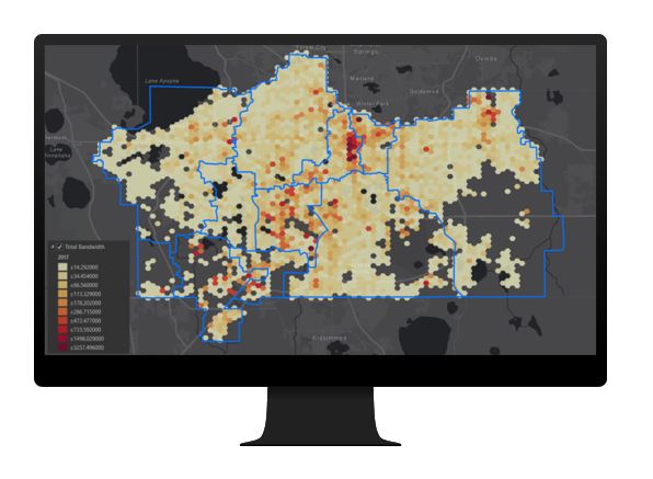
Our customers leverage GIS to fill a pivotal role in resource allocation, ensuring that efforts and investments are directed where they are most needed. By analyzing demographic and geographic data, telecom providers can prioritize network expansion efforts in areas that will yield the highest social impact equitably and improving connectivity for rural communities. Additionally, ArcGIS along with our extensive partner network support the management of physical assets streamlining the maintenance of existing infrastructure and the creation of new assets into the network. Through its comprehensive capabilities, ArcGIS not only enhances operational efficiency but also ensures that projects are grounded in informed decision-making. Its application in rural network expansion demonstrates how technology can be harnessed to overcome geographical and logistical barriers, paving the way for a more connected and inclusive rural America.
Operational Cost Insights
There’s a reason why so many service providers have not built into rural areas. The deployment of broadband networks into rural regions introduces a complex web of capital expense and operational costs. Where ArcGIS plays a critical role, is in elevating cost management strategies, helping telecom companies create and leveraging a detailed view of potential financial commitments. Through its spatial analysis capabilities, ArcGIS enables a comprehensive investigation of regions that are prone to higher costs. Through improved situational awareness, companies can take proactive steps toward resource optimization and quickly understand any shortcomings as they deploy broadband deeper in to rural communities.
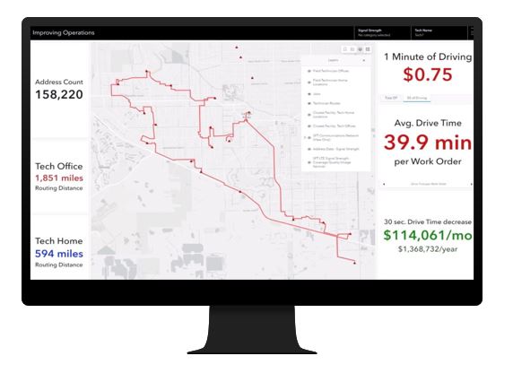
I believe one of the most significant benefits of ArcGIS is its ability to refine operational logistics, such as optimizing technician routing. This is often done in countless other industries Esri supports. In telecom, by analyzing geographic data and existing network infrastructure, companies can identify the most efficient paths for their field teams. Leading to a reduction in travel time and fuel consumption. This optimization not only cuts down operational costs but also minimizes the environmental impact of these activities.
Additionally, ArcGIS aids in dispatch teams in scheduling maintenance and fulfillment work in a way that avoids unnecessary costs. For instance, by identifying areas with recurring issues or higher risks of network failure, companies can prioritize these areas for maintenance. This helps reduce the frequency and costs of emergency repairs. This proactive approach to broadband deployment ensures a more stable and reliable service and enhances customer satisfaction while reducing the costs associated with service disruptions.
Ultimately, I believe ArcGIS empowers telecom companies to make informed decisions, ones that optimize their budgets, before they take action. This informed financial planning is essential for navigating the challenges associated with rural expansion, and helps companies know they can extend their networks efficiently without compromising on quality or financial stability.
Environmental Considerations
As we deploy broadband networks, we need to be good stewards of our environment. We need to think long term about the impacts our actions take, both directly and indirectly. So, in an era where environmental sustainability is a cornerstone in the foundation of companies globally, leveraging ArcGIS for assessing and mitigating the ecological impacts of telecom network expansions is important. For instance, ArcGIS can help organizations perform a comprehensive examination of the carbon footprint associated with extending networks into rural areas. This helps leaders facilitate the development of strategies aimed at minimizing environmental impacts associated with network growth.
ArcGIS’s capability to analyze spatial data plays a pivotal role in promoting eco-friendly expansion practices. For instance, it can be used to identify the most environmentally sensitive areas along network paths, providing potential for avoiding protected areas or actions to help minimize disruptions to natural habitats. By optimizing routing, telecom companies can significantly reduce the amount of excavation and physical impacts required and help preserve the environment.
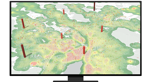
After spending 12 years working in headend facilities, I’ve seen firsthand the amount of energy it takes to run a network. Did you know ArcGIS can support engineering teams with the integration of green technologies into telecom infrastructure? Through detailed analysis, companies can identify optimal locations for deploying renewable energy sources, such as solar panels or wind turbines, to power network equipment. This not only reduces the carbon footprint of operational activities but also ensures that rural network expansion aligns with global sustainability goals.
The proactive use of ArcGIS in environmental planning demonstrates the telecom industry’s commitment to responsible expansion. By carefully assessing the ecological impacts of their projects, telecom companies can ensure that their efforts to connect rural America do not come at the expense of environmental health. This balance between broadband expansion and environmental protection is essential for ensuring that network expansion contributes positively to both the community and the planet.
Employee Performance and Satisfaction
A while ago I was sitting in a meeting where network fulfillment teams were talking about their time to repair goals. Some of the teams were regularly commenting about their inability to meet the goals, that they were out of alignment. To help illustrate the issue, my team created a simple drivetime analysis showing how far a tech could drive in a given amount of time. The issue was immediately clear to all, the technician’s coverage areas were too large to be covered in the amount time the goal gave.
Today, when I think about the expansion of broadband network infrastructure into rural areas, I believe organizations need to re-evaluate employee performance metrics against expansion plans. Traditional benchmarks may not adequately reflect the unique challenges faced by staff involved in rural broadband deployment. ArcGIS offers valuable insights into these challenges, such as drive times, enabling telecom companies to recalibrate performance metrics in a way that is both realistic and safeguards employee satisfaction.
The use of ArcGIS also allows for a data-driven approach to understanding the onsite realities faced by field technicians. By mapping out the geographic spread of network installations and maintenance activities, companies can gain a clear view of the logistical challenges and potential issues affecting their employees. This information is crucial for setting achievable expectations that take into account the additional time and effort required to work in remote areas.
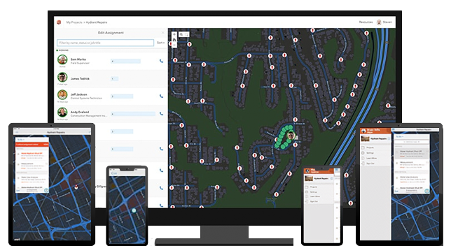
Additionally, ArcGIS can aid in refining company objectives and ensure they align with the operational realities of rural expansion. For example, by analyzing travel times and increased workloads, companies can adjust their scheduling practices to ensure that employees are not overloaded. This consideration for the well-being of staff not only protects the morale of teams but also enhances productivity, as employees feel supported and valued by their employer.
Lastly, I believe leveraging ArcGIS to optimize workloads can help maintain or even improve employee satisfaction levels during the tough phases of network expansion. By identifying potential stressors during broadband deployment and addressing them proactively, telecom companies can foster a work environment that promotes high morale and job satisfaction. For instance, being able to visualize and gain insight into all construction projects taking place in a region, at any time and from any device, means organizations can simplify ops review meetings and project update calls. This strategic use of ArcGIS highlights the importance of considering the human aspect of rural network expansion, ensuring that the workforce remains motivated and committed to the success of projects.
Customer Experience Optimization
At the core of network management for any organization, is the unwavering commitment to delivery of an exceptional customer experience. As broadband is deployed into new territories, challenges such as potential delays in response times can jeopardize customer satisfaction. ArcGIS plays a critical role in mitigating these risks by optimizing network performance and prioritizing enhancements in service delivery.
Utilizing location-based analytics telecom companies can use ArcGIS to gain comprehensive understanding of customer experiences across their entire footprint. This analysis allows for the identification of experience gaps and aides in the prompt resolution of any issues, ensuring that customer satisfaction remains high. As an example, by mapping customer feedback to specific geographic locations companies can pinpoint areas where customer experience may be lagging and understand what is driving the response.
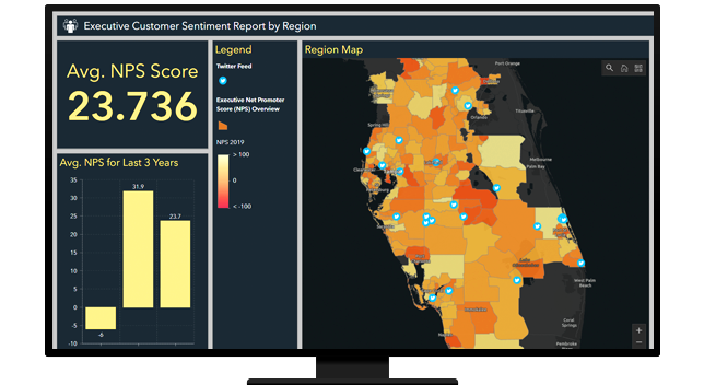
I’ve experience using ArcGIS for supporting the strategic placement of network infrastructure to enhance coverage and reduce downtime, and we see our customers doing this every day. This proactive approach to network planning and optimization ensures that customers in rural areas receive reliable and high-quality service, just like their urban counterparts’ experience. The ability to swiftly respond to and rectify service issues, facilitated by ArcGIS, is key to maintaining a positive customer experience throughout broadband expansion efforts.
By leveraging ArcGIS to understand and safeguard the customer experience, telecom companies emphasize their dedication to service excellence. This commitment, fueled by leveraging location intelligence, ensures that the expansion of networks into rural areas does not compromise the quality of service. Instead, it reinforces the company’s reputation as a reliable provider dedicated to meeting the needs of all its customers, regardless of their location.
Final Throughts
As we continue to explore the challenges associated with rural broadband expansion, it’s clear that the combination of ArcGIS technology and BEAD funding provides a formidable foundation for connecting communities. This comprehensive approach ensures that rural network expansion is not just about extending service reach but about doing so in a manner that is thoughtful, efficient, and mindful of the broader impact on communities, the environment, and the industry at large.
Resources
Learn more about ArcGIS use in Telecommunications
Learn more about ArcGIS use in bridging the Digital Divide
Story Map from 2023 US Broadband Summit: Extending Broadband’s Reach To Those Who Need It Most


