In my role here at Esri, I get to work with some amazing companies doing incredible things in the telecommunications industry. From time to time, I get to share some of these innovative GIS workflows, methodologies, and solutions with colleagues in the industry. I am thrilled to share how Esri and our partnership with Whitestar is revolutionizing the telecom sector through advanced geographic information system (GIS) technology. Esri’s GIS solutions empower telecom companies by transforming vast amounts of spatial data into actionable insights and collaborative resources. By leveraging Esri’s cutting-edge tools, telecom operators can optimize network planning, enhance operational efficiency, and improve customer service. Our technology enables precise asset management, supports regulatory compliance, and facilitates strategic decision-making, making Esri an indispensable partner in the digital transformation of the telecommunications industry.
In our ongoing exploration support of digital transformation in telecommunications, I recently had the pleasure of discussing the concept of “Paper to Polys” with Ed Perry from Whitestar. This intriguing approach involves converting traditional paper or PDF records of telecom infrastructure into digital polygon maps. During our conversation, Ed highlighted how this transformation streamlines asset management, enhances network planning, and boosts operational efficiency. By adopting technologies like TruePOLYGON, which automates the extraction and conversion of infrastructure data into GIS-enabled polygons, telecom companies can significantly improve their processes, drive revenue growth, and stay competitive in a rapidly evolving industry.
Paper to Polys
In my discussion with Ed Perry from Whitestar, we discussed the varying types and quantity of digital transformation taking place in telecommunications, Ed introduced me to this intriguing concept. I’m happy to share our discussion about paper to polys with you.
Randall: What do you mean by “Paper to Polys,” and how is it relevant to the telecom industry?
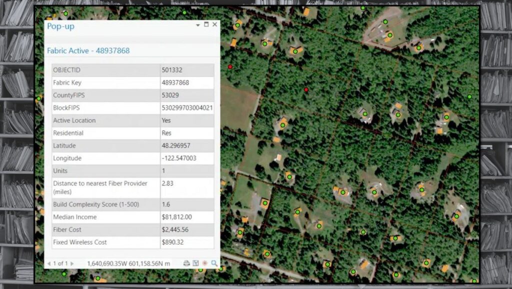
Ed: In telecom, “Paper to Polys” refers to the digital transformation where traditional paper or PDF records of infrastructure assets are converted into digital polygon maps. Telecom companies manage numerous infrastructure agreements and assets, like cell towers, fiber routes, and land leases, which are often documented on paper. This makes it challenging to effectively visualize and manage the spatial distribution of these assets. By transforming these documents into GIS-enabled polygons, telecom companies can better plan network expansions, manage maintenance, and enhance service delivery, all while saving time and resources.

Randall: It seems like a massive undertaking. Is the return on investment justifiable?
Ed: Absolutely. For telecoms, having an accurate spatial representation of infrastructure assets aids in regulatory compliance, site management, and strategic planning. For instance, network engineers can easily locate fiber optic paths for upgrades or repairs, and marketing teams can identify underserved areas for potential expansion. This not only improves operational efficiency but also helps in optimizing investments in infrastructure, thus driving revenue growth.
Randall: Given your extensive background, where have you seen the most significant process improvements?
Ed: A telecom operator I worked with used to manage their asset records in voluminous file cabinets. Whenever a team needed information on an asset, it involved physically locating and retrieving the document, which was not only time-consuming but prone to errors. By converting these records into searchable GIS polygons, we significantly cut down the retrieval time, reduced errors, and enabled simultaneous access across departments. This transformation was pivotal in speeding up decision-making processes and enhancing overall operational agility.
Randall: Transforming all those physical documents sounds demanding. What’s the cutting-edge approach to facilitate this transition effectively?
Ed: It is a challenging task, indeed. The key lies in automation. We employ a technology called TruePOLYGON, which automates the reading of scanned documents, extracts the necessary legal descriptions and infrastructure details, and converts them into digital formats and then creates polygons. This technology leverages A.I. and proprietary algorithms to ensure accuracy and integrate these attributes directly into our GIS systems. This method not only streamlines the process but also reduces the manpower required for manual data entry.
Randall: Is A.I. being used to process these documents on a large scale in the industry today?
Ed: Yes, it’s becoming quite common. For instance, one of our clients had accumulated over 100,000 documents related to infrastructure across multiple regions. These documents varied from paper formats to digital scans, none of which were previously searchable by location. Our A.I.-driven process now allows them to digitally access and manage these assets efficiently, supporting various operational needs from maintenance to compliance.
Randall: How do you ensure the accuracy of these digital maps?
Ed: That’s a great question. The accuracy of digital polygons is crucial for the reliability of any GIS data in telecom. We use the most accurate base map data available, which includes detailed layers like land grids, zoning districts, and right-of-way information. This base helps ensure that our digital representations are as close to reality as possible, which is vital for planning and operational integrity.
In summary, Randall, as you pointed out, these projects might seem daunting, but with the latest technology, the ability to capitalize on the costs, and a solid plan for phased implementation, they can be effectively managed in organizations of any size.
With your vast array of contacts, we would be happy to perform a few POCs at no cost to some of your telecom clients whom you feel might benefit from this new technology. Please have them reach out to me at 720-339-8339 or eperry@whitestar.com
In summary
The transformative potential of GIS technology in telecommunications is immense, and Esri is at the forefront of this innovation. If you’re interested in discovering how Esri can help your telecom company enhance operational efficiency, optimize network planning, and drive growth, we invite you to reach out and learn more. Additionally, the groundbreaking work being done by Whitestar, as discussed in my interview with Ed Perry, showcases the significant advantages of transitioning from traditional records to digital polygon maps. Connect with us to explore how these cutting-edge solutions can benefit your organization and propel you into the future of telecommunications.
Resources
Learn more about Esri in telecommunications here: www.esri.com/telecom
Learn more about Esri’s partnership with Whitestar and their solutions here: Whitestar