Outside the city limits of Austin, Texas, a growing water district has found success by combining Esri’s ArcGIS with Novotx’s GIS-centric asset management solution.
Located near the western edge of Austin, Texas, Travis County Water Control and Improvement District No. 17 (WCID No. 17 or “the District” for short) has managed to optimize preventive and scheduled maintenance operations and increase customer service by combining ArcGIS with Elements XS, a software platform created by Novotx that offers a modern GIS-centric approach to asset management.
Challenge
In 2020, WCID No. 17 was faced with two major problems: a global pandemic, and an aging preventive maintenance software that was no longer meeting the District’s advancing needs. While the pandemic was beyond its control, WCID No. 17 began looking for a solution to modernize its preventive maintenance software.
The District wanted a modern system that provided the ability to document, report, and visualize maintenance activities on a map, with a focus on preventive maintenance planning and scheduling. This data is critical to WCID No. 17’s management of capital infrastructure, life cycle planning, budgeting, and operational outcomes.
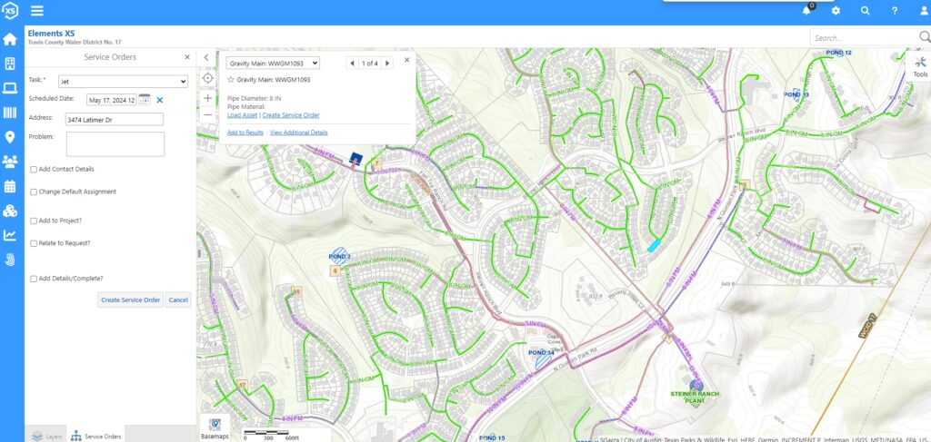
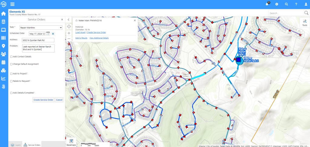
Tracking work activities, especially those of a coordinated nature, in a visually enabling environment was the ultimate vision, and leveraging the District’s ArcGIS investment would be central to the project. With that goal in mind, step one was to prepare the ArcGIS Enterprise environment to support centralized asset inventory and data collection workflows using ArcGIS Field Maps. Once the environment was prepared, the search began for a system that would work with GIS to offer advanced maintenance management features.
Partner
Novotx provides Elements XS, a one-of-a-kind software platform for utilities and local government, offering many solutions to support asset infrastructure management, maintenance, work operations, life cycle analysis, permitting, and land use planning—all in a single interface. Elements XS integrates with Esri’s ArcGIS platform in real time to provide the most up-to-date information and eliminate data synchronization challenges.
Solution
WCID No. 17 had reviewed proposals from three vendors, looking for the best software at the best value. The review process included grading each proposal based on cost of implementation, yearly maintenance and operation, available features, GIS integration, user interface/experience, and ease of use. At the end of this process, the District selected Elements XS as its new asset management application. Its ability to seamlessly integrate with ArcGIS Enterprise was exactly what WCID No. 17 was looking for. In particular, Elements XS could leverage the ArcGIS Enterprise platform as the authoritative system of record for asset inventory and location information, as well as its capacity to efficiently manage maintenance routines with visual dashboards. The District worked closely with Novotx to take Elements XS into production.
Results
Within six months of implementing new workflows based on modern technology, WCID No. 17 was experiencing the following benefits:
Faster turnaround time for equipment servicing
The District experienced a 15 percent increase in equipment uptime while speeding up turnaround time for returning serviced equipment. According to Joseph Kunz, operations manager, “This has been achieved by having equipment status information at our fingertips, making follow-up much easier. This allows the admin team to track parts, ordering, and shipping while allowing management to keep an eye on important metrics like downtime, time to return to service, corrective ticket burn rate, and more.”
Quicker service request resolution
Benefits have also come from the improved ticketing system that tracks service requests from both internal and external callers, leveraging ArcGIS to visualize locations and request statuses. The ability to track the progress of service calls with many different metrics ensures all maintenance items are completed, along with a record of the hours associated with each. This allows management to better forecast personnel requirements for each department, equipment replacements, and where the most staff hours are being spent. All this data also flows into the District’s rate study program, which informs the management of time and money spent on various activities, specifically on water- and wastewater-related work.
ArcGIS Field Maps and Elements XS integration
The ability to easily collect field data while performing work using ArcGIS Field Maps, and at the same time seamlessly updating the Elements XS database, not only helps optimize routine workflows, but also provides the metrics needed for implementing corrective maintenance measures. Such metrics include vital information about how often assets fail and how long it takes to get assets back up and operational.
Tracking issues in the field
With the power of ArcGIS Field Maps leveraged directly by Elements XS, staff can easily track issues with assets in the field. This allows personnel to write work orders while in the field by simply pulling out a smartphone or tablet when, for example, they find an issue at one of the pump stations. This seamless workflow speeds up reporting time while also ensuring it is logged in the system and not forgotten.
The seamless interface between ArcGIS Enterprise and Elements XS has given WCID No. 17 the tools needed to streamline operational processes and provide immediate feedback on whether those processes are working as designed or if they need improving. For example, being able to visualize assets in a single interface powered by ArcGIS Enterprise, the District can not only easily categorize assets based on asset type, functional class, service area, and other important attributes, but also assign the proper maintenance plans and periodicity to them for efficient scheduling of work activities.
The above benefits have resulted in impacting many departments within WCID No. 17, including administration, wastewater, water, IT, collections, maintenance, inspections, safety, compliance, and distribution.
The implementation and combining of Elements XS and ArcGIS has allowed us the ability to establish various metrics that help us operate more efficiently. WCID No. 17 can better track the servicing of equipment and status of work orders. We are able to staff more effectively, which increases production, efficiency, and ultimately improves our bottom line, resulting in a more proficient organization, a satisfied customer base, and happier employees. — Joseph Kunz, Operations Manager
Looking ahead
WCID No. 17 is looking to expand the maintenance process to the water, wastewater, IT, collections, compliance, and distribution departments, and to include reporting requirements for semiannual and annual items. The District will also utilize Elements XS to track fire hydrant maintenance and sewer line jetting workflows. Furthermore, it is looking to track data on water line breaks so it can visualize breaks on heat maps and identify patterns. This could aid in determining line issues to help improve water line replacement plans.
Stay Connected with Esri’s Water Team
ArcGIS is an extensive information system that enables modernization of workflows with easy-to-use applications for the field and office. Strengthen your organization with smart water solutions that will increase efficiency and provide insight for decision-makers. Visit the Esri Water Utilities web site for more information.
Join the Water Utilities Community
Follow #EsriWater on social media: X | LinkedIn
Subscribe to the Water Industry newsletter “Esri News for Water Utilities and Water Resources“
About the author