“A lack of understanding, as well as the failure to collaborate, is a fundamental problem that we’re facing” Jack Dangermond, president and founder of Esri
Throughout the telecommunications industry the persistent search for new ingredients for use in enhancing a company’s ‘secret sauce’ is ongoing, as teams seek to improve metrics, capabilities, customer satisfaction, and revenue realization. In this article, we suggest a way to do more with what you already have in a creative way, to gain understanding before acting. Let’s explore how leveraging land intelligence capabilities within a Digital Twin, built using Esri’s ArcGIS, can revolutionize decision-making processes and drive success.
What is a Land Intelligence System?
In the ever-evolving telecommunications landscape, leveraging the capabilities of land intelligence in Geographic Information Systems (GIS) offers transformative opportunities for organizations. Over decades of industry experience, we’ve observed the challenges and innovations that shape the telecom sector. In our experience, the most successful organizations employ ArcGIS as a strategic foundation for addressing these challenges, enhancing operational efficiencies, and driving customer satisfaction.
Simply put, a land intelligence system overlays various datasets within GIS to address industry-specific challenges. This integration supports tasks such as optimal site selection, project forecasting, market growth potential, and fiscally responsible network infrastructure management. The following list are some of the key datasets our customers find invaluable when using ArcGIS as a land intelligence system:
- Parcel Data: Information on property boundaries, ownership, land use, and zoning. This data is critical for identifying potential infrastructure sites, understanding land access rights, and navigating local regulations.
- Geology and Soil Data: Includes subsurface geology, soil types, and stability. These datasets assess land suitability for construction, potential hazards, and provide awareness to special engineering needs.
- Topography and Elevation Data: High-resolution digital elevation models and topographic maps are vital for planning telecommunications infrastructure. They help teams understand terrain variations, affecting system design, and network resiliency.
- Land Cover and Use Data: Information on vegetation, urban areas, bodies of water, etc., is crucial for signal network planning and environmental impact assessments. This dataset supports strategic planning for network expansions or upgrades.
- Demographic and Socioeconomic Data: Includes population density, economic activity, and community facilities. This data identifies consumer demand hotspots, provides insight to market potential, and helps ensure equitable service distribution.
- Transportation Networks: Data on roads, railways, and other transportation infrastructure assists in planning telecommunications networks, access to sites for construction and maintenance, as well as optimizing service coverage along key corridors.
- Utilities Infrastructure: Information on existing utility lines (electricity, water, etc.) is necessary for site planning to avoid conflicts and leverage existing infrastructure for telecommunications needs.
- Environmental Sensitivity Areas: Identifies protected areas, habitats of endangered species, along with areas presenting environmental restrictions. This data is crucial for compliance with environmental regulations and sustainable infrastructure development.
- Climate and Weather Data: Historical and predictive data on weather patterns and climate conditions inform infrastructure resilience planning, especially in areas prone to extreme weather events.
- Obstacle Data (Built and Natural): Includes buildings, trees, and other structures that can obstruct signals or network routing. This dataset is crucial for accurate signal propagation modeling and identifying potential interference sources.
- Wireless Spectrum Availability: Information on the allocation and use of the wireless spectrum in different areas helps plan network deployments to avoid interference and ensure optimal use of available spectrum resources.
How to Create A Land Intelligence System
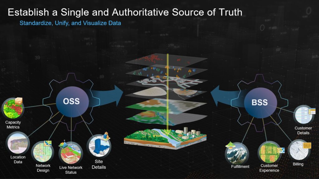
Some of our most successful customers leverage ArcGIS to integrate their operations and business support system datasets into a single source of truth. They then augment their already robust OSS and BSS data with resources from Esri’s Living Atlas of the World, along with third-party datasets such as LIDAR, satellite or drone imagery, parcels and easement agreements, as well as GIS data from other organizations, including slate and local governments or utility pole owners.
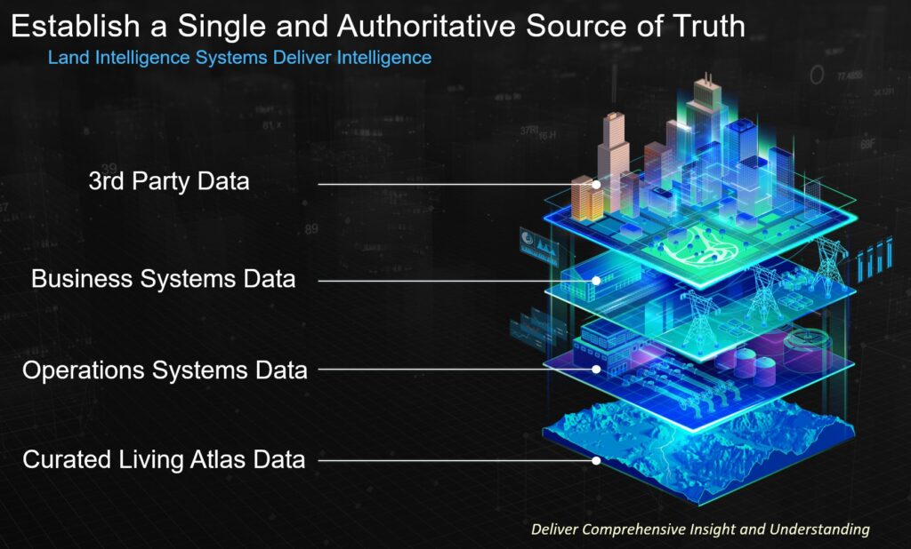
By creating a catalog of location-based assets, these otherwise siloed OSS and BSS resources are better utilized in and put to work as purpose built tools and resources for intelligent decision-making. Some examples include automated design tools for network planning, dashboards for dispatch or customer service, purpose-built web apps for sales or market development, customer-facing construction status maps for company websites, field mobile as-built tools, and countless other solutions providing simplified workflows. By integrating date with GIS, organizations gained improved decision-making capabilities for analysis, visualization, collaboration, and communication throughout the company.
Additionally, by leveraging ArcGIS organizations gain a holistic view of all factors impacting decisions throughout their company. This integration helps teams enhance network coverage and capacity, navigate regulatory, environmental, and social considerations, and support enterprise workflows. ArcGIS’s ability to visualize, analyze, and model these datasets delivers strategic and operational efficiencies for all teams.
ArcGIS enables telecommunications companies to visualize and analyze factors influencing network coverage and capacity, such as population density, topography, and existing utilities. This facilitates the identification of optimal locations for new infrastructure, ensuring maximum coverage with minimal investment. Additionally, ArcGIS aids in strategic planning and resource allocation by simulating various scenarios, providing predictive capabilities.
Furthermore, it helps organizations navigate complex regulatory, environmental, and social landscapes by providing detailed, up-to-date information, ensuring compliance, mitigating environmental impacts, and addressing social concerns. By supporting various workflows and providing powerful visualization, analysis, and modeling tools, ArcGIS enhances efficiency across all departments, driving long-term success in a rapidly changing marketplace.
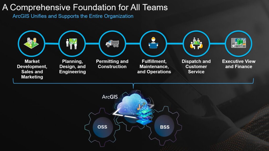
How a Land Intelligence System Empowers Teams
In the fast-changing world of telecommunications, a Land Intelligence System in ArcGIS is essential for planning, designing, and managing networks effectively. GIS helps teams choose the best sites for network infrastructure by analyzing factors like population density, landscape, and existing utilities to ensure wide and reliable coverage. It also helps them improve network design, checks environmental risks, and makes project management easier by providing real-time updates on construction progress and resource status while also simplifying communication and collaboration.

GIS technology helps teams simplify field operations, boost customer experience by showing real-time network performance, and ensure compliance with regulations. By mapping and analyzing network assets, GIS helps service providers make smart decisions about maintenance and upgrades, keeping the subscriber experience and level of service high. Additionally, GIS aids teams with market analysis and strategic expansion efforts, driving both growth and competitiveness while aiding in preparation for, and recovering from, disasters quickly and effectively. Let’s take a look at a few teams and how a land intelligence system in ArcGIS aides their daily lives.
Planning and Design of Networks
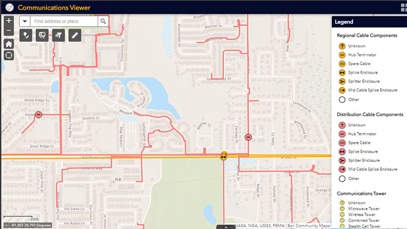
- Optimal Site Selection with Spatial Analysis: GIS empowers service providers with spatial analytics to pinpoint optimal sites for infrastructure deployment. By evaluating factors such as population density, topography, and existing utilities, organizations can optimize network design, ensuring expansive coverage and reliability.
- Network Design Optimization: GIS technology facilitates the visualization and analysis of vast geographical data, enabling telecom providers to devise network layouts that promise maximum efficiency at minimal costs. This strategic planning streamlines deployment and anticipates future expansions or modifications with precision.
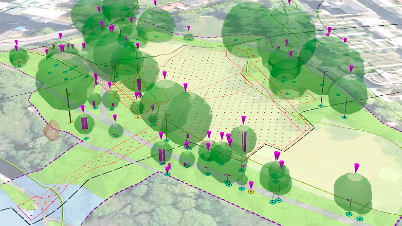
- Environmental Risk Assessment: Incorporating GIS into the planning phase allows for a comprehensive assessment of environmental risks, safeguarding infrastructure against potential disasters and ensuring network resilience.
Engineering and Construction Efforts
- Enhanced Project Management: The integration of GIS in engineering and construction phases transforms project management by offering real-time insights into construction progress, resource allocation, and logistical operations. This visibility ensures that projects adhere to timelines and budgets, mitigating potential delays or cost overruns.
- Streamlined Coordination: Navigating the complexities of public and private land use becomes seamless with GIS. Mapping utility lines, public infrastructure, and property boundaries on a unified platform facilitates compliance with regulations and preemptively addresses potential conflicts, streamlining construction efforts.
- Field Operations Empowerment: The mobile capabilities of GIS revolutionize field operations by enabling engineers to access, update, and share project data instantaneously. This connectivity enhances the accuracy of field data and optimizes construction and maintenance activities.
Customer Experience and Quality of Service
- Real-time Network Performance Visualization: GIS technology equips telecom providers with tools to map network performance across different regions. Identifying areas with degraded service or high congestion enables swift remediation, enhancing overall customer experience.
- Transparent Service Availability: By leveraging GIS-enabled maps, service providers can offer customers and prospects transparent and accurate information regarding service availability and coverage areas, fostering trust and satisfaction.
- Efficient Incident Management: The ability to quickly pinpoint affected areas during network issues or outages is crucial. GIS facilitates efficient incident response and management, minimizing downtime and improving service reliability.
Regulatory Accountability
- Demonstrable Compliance: In the telecom industry, adherence to regulatory standards is paramount. GIS assists in documenting and proving compliance through detailed mapping and record-keeping of network deployments and environmental assessments, ensuring transparency and accountability.
- Spectrum Management and Regulation: Managing spectrum usage and compliance with regulatory bodies is streamlined with GIS. The technology supports minimizing interference and optimizing spectrum allocation, ensuring harmonious coexistence with other services.
Strategic Operations and Oversight
- Comprehensive Asset Management: The depth of insight provided by GIS into network assets—including their condition, performance, and lifecycle—enables informed decision-making regarding investments, maintenance, and upgrades, ensuring the longevity and resilience of the network infrastructure.
- Informed Market Analysis and Expansion: Utilizing GIS for demographic and geographical analysis empowers telecom providers to identify untapped markets, customize services to meet localized demands, and strategically plan for expansion, driving growth and competitiveness.
- Disaster Preparedness and Recovery: GIS is instrumental in disaster management, from preparedness to recovery. By modeling potential impacts and coordinating with emergency services, telecom providers can ensure rapid restoration of services, mitigating the impact on customers and infrastructure.
The Road Ahead: Leveraging Land Intelligence
Throughout the telecommunications industry, leveraging the capabilities a land intelligence system provides can revolutionize decision-making processes and drive companywide success. It supports tasks such as optimal site selection, project forecasting, analyzing market growth potential, and provides a foundation for fiscally responsible network management. Key datasets of a land intelligence system include parcel data, geology and soil data, topography and elevation data, land cover and use data, demographic and socioeconomic data, transportation networks, utilities infrastructure, environmental sensitivity areas, climate and weather data, obstacle data, and wireless spectrum availability. By creating a catalog of location-based assets, organizations can utilize these siloed resources in a comprehensive way, including automated design tools for network planning, dashboards for dispatch or customer service, purpose-built web apps for sales or market development, and customer-facing construction status maps.
By integrating existing OSS and BSS assets with ArcGIS, organizations gain improved decision-making capabilities for analysis, visualization, collaboration, and communication throughout the company. This enables organizations to visualize and analyze factors influencing network coverage and capacity, facilitating the identification of optimal locations for new infrastructure, ensuring maximum coverage with minimal investment. It helps organizations navigate complex regulatory, environmental, and social landscapes by providing detailed, up-to-date information, ensuring compliance, mitigating environmental impacts, and addressing social concerns. A land intelligence system supports various workflows by providing powerful visualization, analysis, and modeling tools. Remember, the capabilities of ArcGIS enhances efficiency across all departments, driving long-term success in a rapidly changing marketplace and is a strategic imperative for telecom providers aiming to lead now, and in the future.
Learn more about ArcGIS use in Telecommunications: www.esri.com/telecom
Learn more about integrating OSS and BSS with ArcGIS: ArcGIS Architecture Center