America’s lack of affordable and attainable housing over the last five years has caused a crisis in communities across the country. The supply of housing has yet to keep up with demand, particularly as more Millennials pursue home ownership. This lack of supply has caused a spike in average sales prices for houses sold in the U.S. According to the Federal Reserve Economic Data (FRED), that price has increased by 31% since Q1 2019, exponentially outpacing wage increases.
Local governments are struggling with finding and implementing housing policies to quickly curb this trend and put more people into attainable housing. Regional agencies play a key role in this, as well since housing problems are usually not isolated to a single city in a metro area.
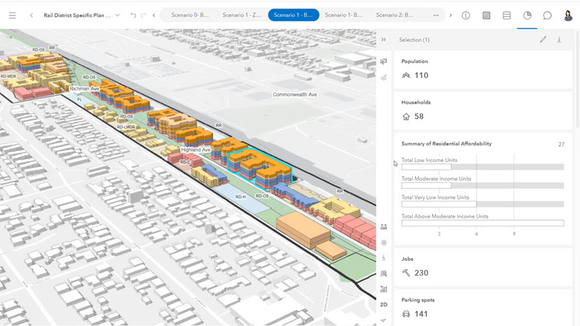
A Data-Driven Approach to Housing
The Mid-America Regional Council (MARC) serves the 119 city and nine county governments of the bi-state Kansas City region, as well as serving as the MPO for the region. Last year, MARC set out on a data-driven approach to deal with the housing shortage in the region by supporting the work of the Greater Kansas City Regional Housing Partnership with a Housing Data Hub. This dashboard developed in ArcGIS Experience Builder provides a comprehensive overview of housing in the Kansas City area.

Starting with demographic data, users can identify income, education, race, and household size at the tract, city, or county level with authoritative content from the U.S. Census and American Community Survey.
Housing supply, stock, and occupancy are also covered by the same geographies and supported by maps and charts. Recently, the GIS team at MARC also added data for HUD-defined housing problems (e.g. incomplete plumbing, overcrowding, and cost burden). This data can also be categorized by occupant tenure (renting or owning).

The Low-Income Housing Tax Credits (LIHTC) program awards tax credits to housing developers in exchange for agreeing to reserve a certain fraction of rent-restricted units for lower-income households. In the Housing Data Hub, government leaders can identify where these properties exist, but also understand the properties by program type, total units available, and roll-off period.

Collaboration in Housing Policy
Solving the housing shortage won’t happen overnight, but the deployment and use of the Housing Data Hub helps enable a data-driven collaborative approach across the 128 local governments in the area.
“Like many communities across the nation, affordable housing is a challenge in the Kansas City region. We’re working with local leaders and stakeholders to address issues and identify possible solutions,” said Lauren Palmer, MARC’s Director of Local Government Services. “The Housing Data Hub has been instrumental to building a shared understanding among partners and leaders to ground strategies and inform policy and decision-making. The hub not only provides data – but generates discussion and action.”
This innovative approach by the Kansas City Regional Housing Partnership and Mid America Regional Council embodies the concepts of the geographic approach to planning. Now, all the dozens of local governments in the Kansas City region are working with the same authoritative data in deriving housing policy solutions that meet the modern needs of their respective residents.
To see how other state and local governments are using ArcGIS Experience Builder to tell their stories, go to the Experience Builder Gallery. If you have questions about how to apply this and other Esri technology to your planning and community development workflows, please contact your Esri Account Team or contact us directly at planningteam@esri.com.