Santa Clarita Valley Water Agency (SCV Water) was formed by a merger of three retail water agencies and one wholesale agency in the Santa Clarita Valley, resulting in a service area of 195 square miles. SCV Water serves a population of approximately 300,000 through 75,000 retail water connections. SCV Water’s vision is to provide exemplary water management for a high quality of life in the Santa Clarita Valley.

Challenge
SCV Water faced a significant challenge following its formation, as each agency brought distinct practices for managing assets and infrastructure. These disparate approaches created a fragmented environment in which asset information was scattered across various systems and used different formats and processes. The lack of a cohesive strategy not only made it difficult to consolidate data, but also posed challenges in maintaining operational efficiency and advancing toward a unified, geographic information system (GIS) technology-centric asset management solution.
A particularly acute issue arose in the management of vertical assets such as pump stations, lift stations, and wells. Unlike linear assets that are often mapped and visualized in GIS, these vertical assets lacked accessible, map-based tools to provide clear, spatial context. Operations staff were left relying on tabular records or legacy systems, which often resulted in difficulty locating specific components for routine maintenance or part replacement. These inefficiencies not only delayed critical tasks but also increased the risk of errors, further straining resources. The absence of an integrated system capable of supporting both linear and vertical asset workflows underscored the urgent need for a comprehensive solution to streamline processes, improve data accuracy, and enhance operational coordination.
Partner
SCV Water engaged DCSE, an Esri partner, to tackle the challenge of organizing and consolidating the utility’s asset information in preparation for implementing an asset management system. DCSE specializes in providing ArcGIS Utility Network migration services, helping clients like SCV Water transition to more advanced GIS capabilities. As a leading engineering and GIS consulting firm, DCSE develops tailored solutions for local, state, and federal agencies, as well as private utility companies, particularly in the wet utilities sector. Founded in 1989, DCSE specializes in large-scale information systems, powered by a skilled team of engineers, project managers, and GIS experts.
Solution
SCV Water implemented Esri ArcGIS technology as a unified framework to manage linear assets, such as distribution and transmission networks, with the goal of streamlining processes and enhancing data integration. As part of this initiative, SCV Water’s road map included adopting Esri’s ArcGIS Utility Network for linear asset management. This transition presented an opportunity to extend the technology’s capabilities to vertical assets. However, the project team soon realized that the stakeholders managing vertical assets differed significantly from the GIS experts typically responsible for linear assets, requiring a tailored approach to ensure successful implementation.
“Facing a common challenge, operations, engineering, GIS, and our partners at DCSE came together, allowing us to forge a new path.”—Jose Huerta,GIS Manager, SCV Water
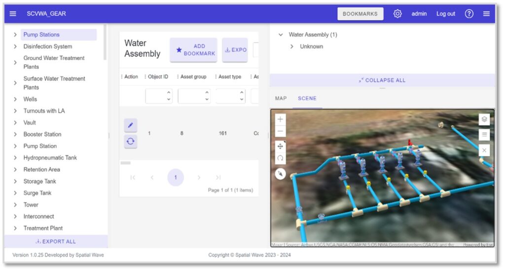
To address this challenge, the team developed GEAR (“GIS-enabled asset registry”), a user-friendly solution tailored for non-GIS professionals. GEAR empowers asset managers with limited GIS expertise to effectively manage vertical assets through an intuitive, web-based interface. By leveraging the 3D capabilities of the Utility Network data model, GEAR provides a powerful tool for managing and visualizing vertical assets. Users can view, locate, and interact with assets across over 90 pump stations, more than 60 tank sites, and over 50 wells, and additional integrations, such as SCADA data, are planned for the near future.
This innovative solution fosters seamless collaboration among stakeholders while providing easy access to GIS-based data, significantly enhancing operational efficiency. Additionally, it serves as a powerful training tool, enabling staff to deepen their understanding of SCV Water’s facilities and assets. By combining knowledge retention with data preservation, this dual functionality lays a robust foundation for a fully integrated, GIS-centric asset management system, ensuring sustainable and efficient operations well into the future.
“The adoption of [Esri’s] Utility Network has allowed us to not only streamline the management of our linear assets but also extend these powerful capabilities to vertical assets. With GEAR, our non-GIS staff can manage these assets without needing to know GIS. The integration of 3D visualization and drone-based reality capture gives us a truly comprehensive view of our facilities, helping transition and empower our next generation of water professionals.”—Cris Pérez, Director of Technical Services, SCV Water
Results
GEAR is instrumental in managing vertical assets at SCV Water, supporting up to five levels of the asset hierarchy. Non-GIS staff contribute effectively by adding detailed components, such as pump starters, enhancing asset data accuracy. This improved data access has strengthened quality assurance and control, enabling more precise asset annotations. Operations staff now utilize 2D and 3D GIS-based views of assets in pump stations; lift stations, including child assets; and other vertical facilities to locate components. This has eliminated relying on laborious tabular queries and searches that often resulted in staff’s selecting incorrect assets with no visualization ability. The intuitive, web-based interface enhances accessibility for a broader range of operational staff, regardless of their GIS expertise. Its user-friendly design and vertical asset views ensure that even nontechnical users can efficiently navigate the system, manage asset hierarchies, and access critical data.
“The ease of use of GEAR fosters widespread adoption across teams, significantly improving the workflows between operations and GIS staff. This project has increased our maintenance efficiency and enhanced our understanding of the vertical assets we manage.”—Michael Alvord, Director of Operations & Maintenance, SCV Water
Implementing Utility Network for facility management and linear assets will enrich the geodatabase with comprehensive information, creating a unified repository for all assets. This consolidation represents a major milestone in SCV Water’s journey toward a GIS-centric asset management system, paving the way for full-scale implementation and enhanced operational efficiency.
Enhanced Collaboration and Improved Operational Efficiency
SCV Water overcame the challenges of consolidating fragmented asset management practices by partnering with DCSE to implement ArcGIS Utility Network and introduce GEAR as a value-added Utility Network solution specifically designed for vertical asset management. While Utility Network provides a robust framework for managing linear assets, GEAR extends its functionality by addressing the unique complexities of vertical assets, such as pump stations, lift stations, wells, and treatment facilities. The solution seamlessly integrates with Utility Network, leveraging its 3D modeling capabilities to create an intuitive, web-based platform accessible to non-GIS professionals. This integration allows operations and engineering teams to manage vertical assets with the same efficiency and precision as linear networks, bridging the gap between traditionally siloed workflows. By enabling accurate data entry, detailed component tracking, and multilevel asset hierarchies, GEAR ensures that vertical assets are managed with the same rigor as linear infrastructure in Utility Network. A key advantage of this unified approach is the elimination of the need to synchronize linear and vertical assets with external asset management systems, as all assets are consolidated within Utility Network, serving as a single, cohesive registry.
Moreover, the design streamlines workflows specific to vertical asset management, enhancing team collaboration across departments while significantly improving operational efficiency. Its web-based interface makes it easy for diverse stakeholders to access and update critical asset data, ensuring a unified and up-to-date geodatabase. This tailored approach not only adds value to SCV Water’s Utility Network deployment but also positions this reference architecture as a critical enabler of SCV Water’s goal of achieving a fully integrated, GIS-centric asset management system.
Stay Connected with Esri’s Water Team
ArcGIS is an extensive information system that enables modernization of workflows with easy-to-use applications for the field and office. Strengthen your organization with smart water solutions that will increase efficiency and provide insight for decision-makers. Visit the Esri Water Utilities web site for more information.
Join the Water Utilities Community
Follow #EsriWater on social media: X | LinkedIn
Subscribe to the Water Industry newsletter “Esri News for Water Utilities and Water Resources“
About the author