In today’s rapidly evolving urban landscapes, parks serve as vital sanctuaries that promote physical, mental, and social well-being. The integration of Geographic Information Systems (GIS) into park planning and management has opened new avenues for creating healthier communities. By leveraging GIS technology and the geographic approach, park planners can ensure that parks are designed and maintained to maximize health benefits for all community members. In this blog I cover 5 health benefits to be derived from leveraging GIS tools to plan and manage parks.
- Promoting Physical Activity
As a cornerstone of public health, active living helps prevent the onset of chronic diseases such as obesity, diabetes, and cardiovascular diseases. Parks provide opportunities for various forms of physical activity, from walking and jogging to team sports and playground activities. Having good proximity to parks and recreational facilities is strongly associated with increased levels of physical activity among residents.
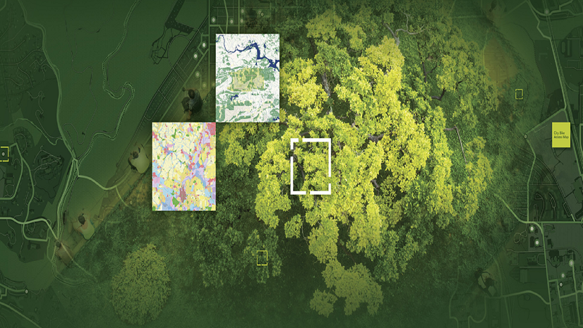
Within parks, GIS allows planners to map activity hotspots where physical activity is most concentrated. By analyzing data on park usage, planners can ensure that these areas are equipped with the necessary facilities to support a range of activities like jogging paths, basketball courts, or soccer fields. Optimizing these settings encourages more frequent and intense physical activity.
Rancho Cucamonga, CA – Parks Locator App assists frontline staff by providing the community with accurate recreation information.
No matter what a person’s physical abilities are, parks should be accessible and usable by everyone. GIS technology can help in designing accessible routes, identifying barriers, and complying with Americans with Disabilities Act (ADA) standards, all while creating spaces that cater to the needs of all community members.
- Supporting Mental Health
Have you ever had that feeling of “ahhhhh” when you set foot into a park? Well, access to parks and green spaces has profound effects on mental health. Natural settings provide a respite from the stressors of urban life, offering spaces for relaxation, reflection, and social interaction.
We all need those “ahhhhh” moments – but sadly not everyone has the option. Applying GIS technology we can answer questions like, “Where are all the parks in the community?” and “Which neighborhoods have limited access to green spaces?” Gap analysis can highlight where communities are underserved and guide investments to improve park access in urban environments.
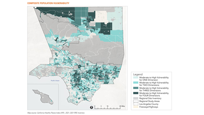
In Los Angeles, County, this map focuses on population vulnerability, going beyond simple population density data to ensure everyone has access to nature and recreational facilities.
Furthermore, GIS can help planners design parks that enhance mental well-being by adding therapeutic landscapes that incorporate elements like serene water features and lush greenery. Individuals with regular access to neighborhood parks report lower levels of depression.
- Fostering Social Connectedness
Parks are not just spaces for individual activities; they are also communal spaces that foster social interaction and build community ties. Social connectedness is a critical component of overall health, reducing feelings of isolation and promoting a sense of belonging. This is particularly important for adolescents and older adults.
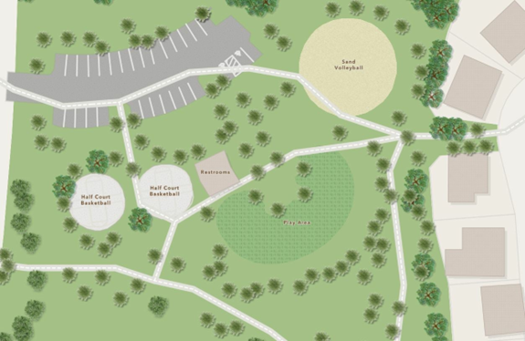
GIS can help planners understand how parks are used for social purposes. By studying patterns of park usage, planners can identify areas where social interactions are most likely to occur and enhance these spaces with amenities that encourage gatherings, such as picnic areas, playgrounds, and sports facilities.
And no surprise here, but parks that are designed with community input are more likely to meet the needs and preferences of local residents. GIS can facilitate community engagement by providing visualization and collaboration tools that help residents understand and participate in the planning process. This approach ensures that parks are designed to be welcoming and inclusive, fostering stronger community bonds.
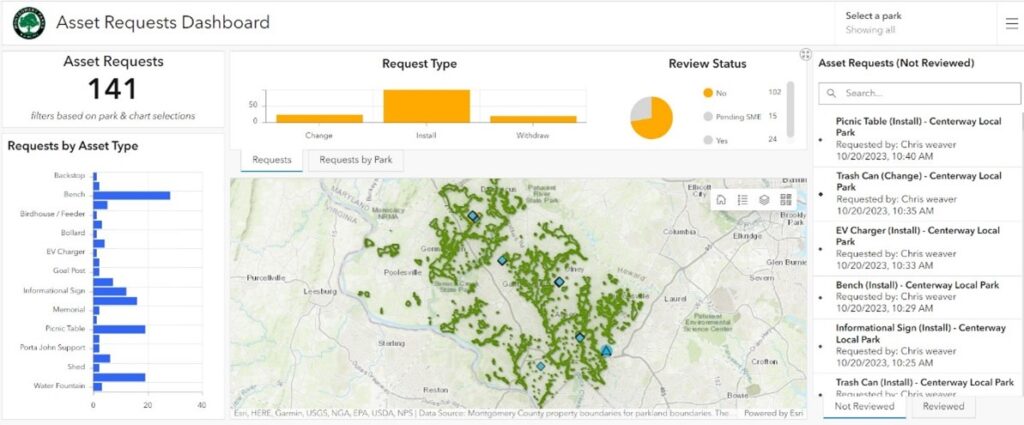
Asset Request Dashboard provides a centralized view of park amenity requests and their review status.
- Responding to Public Health Crises
The COVID-19 pandemic highlighted the essential role of parks in maintaining public health. With many indoor facilities closed, parks provided a vital outlet for physical activity and social interaction while allowing for social distancing. For me, getting out for a daily walk in the park was my only outdoor activity for nearly 2 years.
I wasn’t alone. During the pandemic, many communities saw a surge in park usage. This data, combined with GIS visualization and analysis helped planners adapt their designs to meet evolving public health guidelines. For instance, GIS can clarify areas where social distancing is challenging and suggest modifications to improve safety.
- Mitigating Climate Change
In the face of accelerating climate change and its harmful impacts on human health, parks have emerged as critical components in the development of sustainable and resilient communities. Parks not only provide essential green spaces that offer shade and cooling when it’s hot, they also contribute significantly to the economic and social vitality of communities.
As climate change intensifies, GIS facilitates identification of places with the highest risk for extreme heat or flooding, the populations most vulnerable to these conditions, and supports the ability to design parks that mitigate these risks. By incorporating green infrastructure, like rain gardens and permeable surfaces, parks can help manage stormwater and reduce urban heat, all while protecting human health.
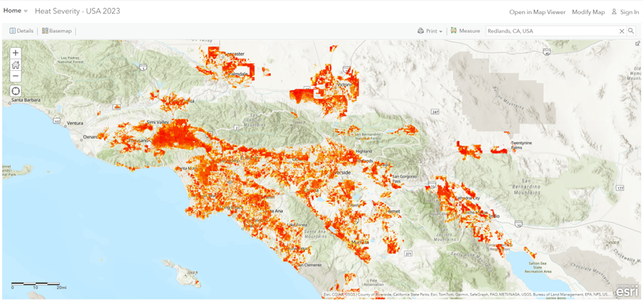
This layer contains the relative heat severity for every city in the United States, including Alaska, Hawaii, and Puerto Rico. This 30-meter raster was derived from Landsat 8 imagery band 10 (ground-level thermal sensor) from the summer of 2023 and provides insight into areas of high risk.
GIS Helps Build and Manage Healthy Communities
GIS technology is transforming the way parks and recreation professionals plan, manage, and optimize green spaces. By leveraging GIS, park planners can create healthier, more resilient communities that benefit from increased physical activity, improved mental health, and stronger social connections. As we navigate the challenges of the 21st century, the integration of GIS into parks and recreation planning will be essential for fostering vibrant, healthy and equitable communities.
Learn more about planning parks and recreation for the next generation using GIS.