Environmental consulting integrates multiple disciplines to navigate the complex interplay between projects and their environmental contexts. It involves collaboration among experts in biology, sociology, and physical sciences, as well as architects, engineers, and construction professionals, to address daily environmental industry challenges. These experts play a crucial role in a variety of projects, deciphering interaction between humans and their natural surroundings to identify, examine, and address intricate issues. The geographical aspect of every environmental factor, be it biodiversity, habitat, pollution, or regulatory compliance, must be well understood by environmental consultants.
Applying Location Data for Environmental Insights
Location is central to every stage of a project, making it an essential element in the environmental consulting business.
GIS is a tool that enables the environmental consultants to:
- Provide clear, visual representations of environmental data and project impacts, which fosters transparency, informed discussions, and strategy development.
- Enhance electronic data collection in the field.
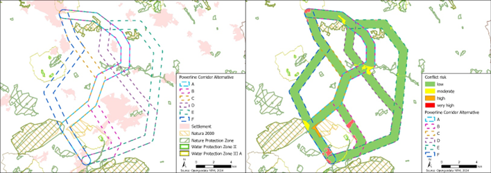
- Assess environmental impact and ensure compliance with regulatory standards, streamlining the permitting process.
- Provide more effective advice on sustainable practices.
“The core objective of environmental consulting firms is to effectively perform environmental impact analyses for a wide array of projects”, says Jennie Byron, Esri’s lead of the Environmental Consulting team and AEC Senior Solutions Engineer. “Achieving this objective while maintaining a high level of scientific integrity and producing defensible results is what distinguishes the most successful firms. Esri supports these aims with out-of-the-box tools for analysis and collaboration, allowing environmental consulting firms to conduct their analyses more efficiently and effectively with the leading GIS software in the industry – ArcGIS.”
A significant benefit of using GIS to digitally transform environmental workflows is flattening the data loss curve by ensuring reliable transfer of information between project phases. Project teams can use ArcGIS GeoBIM to connect geospatial data with design and construction information in Autodesk Construction Cloud and Autodesk BIM 360. Read more on this workflow here.
Leveraging lessons learned and insights from each project can transform challenges into opportunities for growth and innovation, ultimately enriching service offerings and value propositions to clients.
Digitally Enhancing Permitting, Regulatory, and Compliance Processes with ArcGIS Solutions
Even small projects must comply with federal, state, and/or local permitting, regulatory, and other requirements.
Understanding what data are needed for the project, the data gaps, where the data are stored, and how datasets can be shared with stakeholders is crucial. Leveraging authoritative data sources with metadata, like those found in the ArcGIS Living Atlas of the World, is essential to defensible analysis, mitigation, and reporting.
The White House’s April 2024 announcement of a $30 million investment in innovative technologies to improve the efficiency of federal permitting demonstrates federal support for the digitization and digital delivery of NEPA documents. Flexible and scalable applications like ArcGIS Workflow Manager support this digital approach by coordinating repeatable GIS and non-GIS operations.
Getting Projects Started with ArcGIS Living Atlas
When a new project opportunity or Request For Proposal (RFP) presents itself, quick action is often necessary. Access to authoritative spatial data is crucial for understanding a project’s location, status and potential future conditions. Most state and local governments maintain open data portals that include public GIS data like tax parcels, road centerlines, wildlife habitat, or water features.
The ArcGIS Living Atlas of the World is a premier collection of geographic information, offering data from state and local governments, as well as trusted organizations such as the USGS, FEMA, and NOAA. This resource hosts a wide range of verified information, from basemaps and imagery to terrain and landscape layers.
“Having a clear understanding of resources and identifying any missing elements is imperative for a prompt and effective response,” notes Claudia Anderson, Esri’s Senior Global Account Manager. “Visualizing patterns of survey results in a dashboard can help identify resourcing gaps and strengths and help strategize for growth in new sectors.”
For a great example of how AEC firms can leverage Living Atlas, check out this StoryMap.
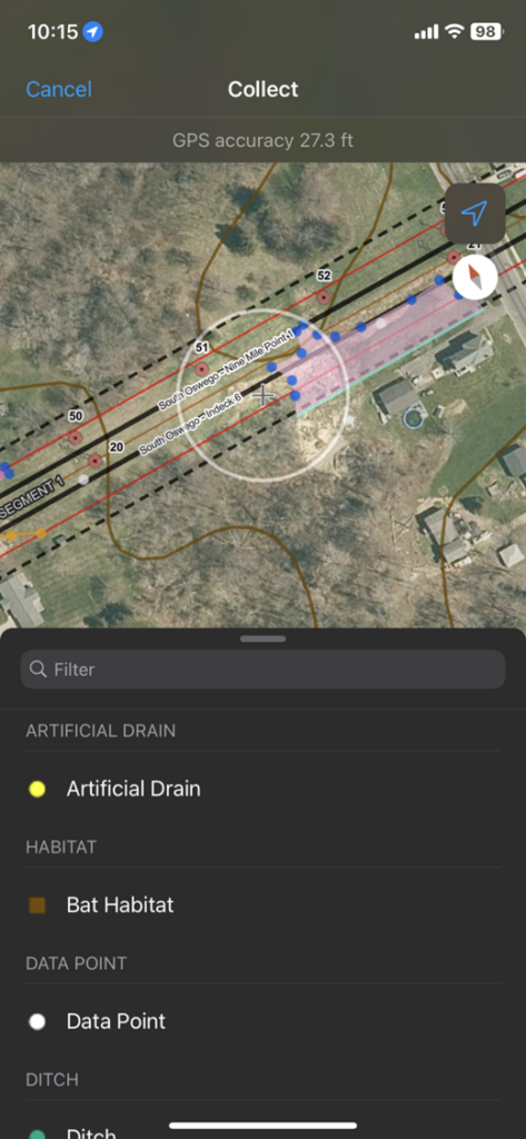
Streamlining Field Workflows and Data Collection with ArcGIS Field Apps
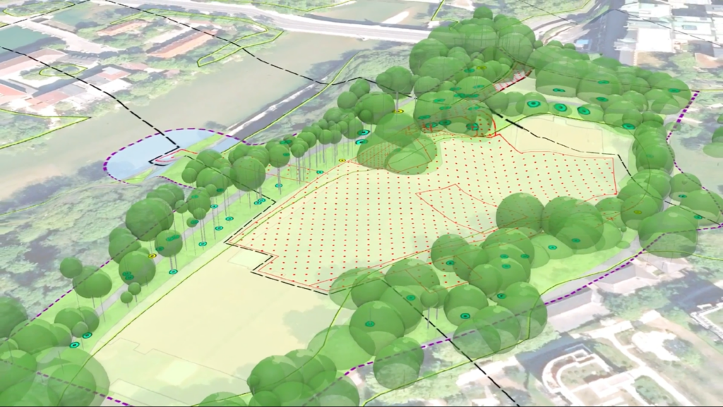
After consulting with permitting agencies, projects usually require more detailed information related to impacts on sensitive resources in the area. Field data collection involves capturing information on various factors such as wetlands, species of birds, insects, fish, or plants.
To comply with requirements of the National Environmental Policy Act (NEPA), field data may need to be collected to further describe air quality, noise impacts, cultural heritage, geotechnical engineering, and visual considerations. Esri’s GIS-based field applications like ArcGIS Survey123, ArcGIS Field Maps, and ArcGIS QuickCapture enable precise and real-time data collection, transforming traditional paper-based processes into efficient, collaborative digital workflows.
Effectively Communicating Data-Driven Decisions with ArcGIS
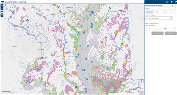
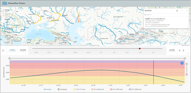
Collecting information is just one part of the process. The next step is to analyze, then effectively communicate what your conclusions mean for the project. For example, GIS tools like ArcGIS Pro can generate groundwater contours to understand flow on a site, display metrics on web apps, and trigger updated analyses based on stakeholder feedback.
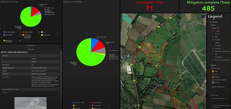
The ArcGIS Online and ArcGIS Enterprise environments, in conjunction with app builders, enable you to quickly create intuitive, information-rich applications. These applications share out information to project teams and stakeholders, such as contaminant sampling results on EPA Superfund sites.
“GIS technology allows environmental consultants to gain an improved understanding of contaminated sites,” says Mehmet Secilmis, Esri’s Senior Global Account Manager. “By gathering and analyzing remarkable volumes of environmental data, GIS enables users to observe, measure, and monitor remediation sites with incredible detail and precision.”
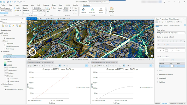
Low-code ArcGIS app builders create applications for specific needs, such as easy operational dashboards that report field data in real time. Tools like the Flood Simulation in ArcGIS Pro give users simple access to execute complex processes, automating and streamlining time-consuming analyses and ensuring efficient project delivery.
Using communication tools like ArcGIS StoryMaps allows consultants to present data in engaging, narrative formats that resonate with stakeholders. ArcGIS Hub facilitates project information sharing, enabling teams to collaborate effectively and track progress dynamically.
The Future of GIS in Environmental Consulting
GIS technology has been providing the environmental consulting industry with comprehensive solutions that incorporate the latest technology, comply with regulations, and enables more effective ways to engage with stakeholders. It enhances the understanding of project contexts, enables effective collaboration, and empowers decision-makers with powerful visualization tools.
Environmental consultants have a unique opportunity to shape a meaningful digital transformation within the environmental industry, going beyond current day-to-day workflows. More efficient, digital data collection, data management, communication, and submission processes, produce results that provide a deeper understanding of potential impacts in less time, and at many scales.
To learn more about leveraging Geographic Information System data and the geographic approach for environmental consulting visit this StoryMap.