The Open Group OSDU Forum seeks to reduce data silos by creating an open, standards-based, technology-agnostic data ecosystem that drives innovation for the energy industry. With over 230 member companies, the OSDU Forum leverages an Aligned Autonomy approach, where individual member companies are independently working toward a common vision, to foster innovation and accelerate new capabilities for the platform.
It is under this model that the OSDU Forum’s Geomatics working group surfaced the idea for a GIS API inside the OSDU Data Platform. The idea evolved out of comments and questions from across the industry participants leading to the “Consumption Zone – GIS Canvas” entry in the OSDU backlog.
Several companies came together to comment and further refine the requirements for this backlog item and in working together with the OSDU OMC, PMC and Architecture committees landed on the consumption zone approach.
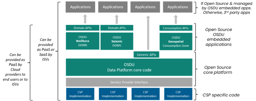
Figure 1. Conceptual overview of OSDU
The OSDU Geospatial Consumption Zone (GCZ) is an integral part of OSDU and is available now for implementation. It is open source and can work with any OSDU release from m13 or later. (The current release at the time of publishing is m23)
The GCZ solution includes three main components. A transformer that processes the data, Apache Ignite for data storage of the geospatial index, and Koop for generating the map services. This approach has delivered the performance required along with the flexibility and scalability needed to handle all of the user requirements presented.
The GCZ transformer leverages several of the OSDU core services to understand, access, and process the OSDU data to make it ‘map ready’. Today, the GCZ can create geospatial features for wells (surface, bottom & trajectory), 2d/3d seismic (nav, surveys, and live trace), logs (as points and lines along the trajectory), picks/tops, and horizon extents.
It is expected that the OSDU Data Platform will continue to grow and evolve, and the GCZ has been designed to grow and evolve with it. The GCZ team have completed the original data coverage scope and are already working to add additional data types like seismic bins, reservoir grids, 2d shotpoints, geocontext features, geo-referenced images, grav/mag, documents, and other data type priorities as they emerge..
For operators this means no longer having to maintain complex ETL processes to publish map services and for ISVs they will be able to use OSDU map services to use in their own OSDU enabled applications and services.
It also means that users will now have access to a geospatial index of the data you hold in OSDU for any search, query, analytic or visualization needs you may have; from simple mapping to advanced data science the GCZ makes valuable data available for driving new insights.
One of the most common workflows we see is leveraging the GCZ services in configuring a map base data catalog of OSDU content that enables browse and/or search capabilities against your OSDU data. Using tools like the Esri Experience Builder you can configure applications to support specific user needs – like exposing your OSDU data in simple to use interfaces enabling data discovery.
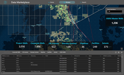
Figure 2. No code data browse app configured with ArcGIS Experience Builder
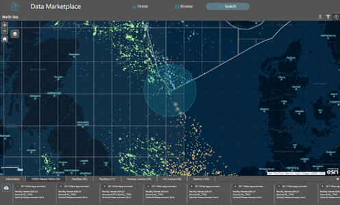
Figure 3. No code data search app configured with ArcGIS Experience Builder
The same map services can also be used in ArcGIS Pro, Petrel, Geographix or any other software that supports map services. This ensures the data you are using in your map and analytic workflows is always in sync with the data used in your other subsurface workflows supported by OSDU and OSDU enabled applications.
If you are interested in learning more about the GCZ project you can follow the work on the GCZ status page, or if you are ready to try the GCZ in your own OSDU environment, then you can find everything you need on the documentation pages. A useful area to start is with the supported data types information which is updated as we add additional data types to the GCZ. (quick view below)
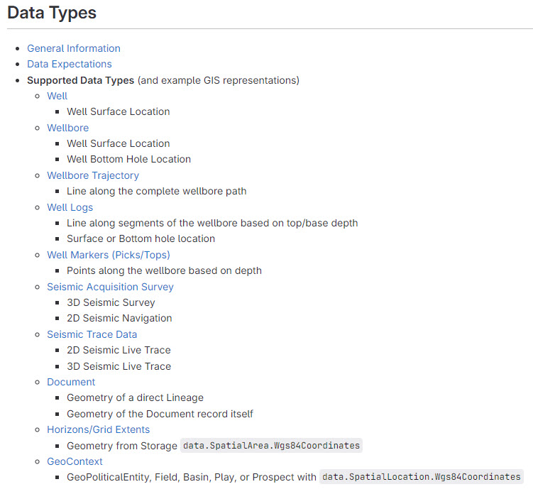
Figure 4. Supported Data Types (as of July 2024)
The GCZ can be installed anywhere that has internet access to your OSDU environment. Several companies have installed it in their existing GIS environment. If your OSDU environment is provided via one of the OSDU cloud partners, then it is available today in the IBM Open Data & AWS Energy Data Insights offerings and soon will become part of Microsoft Azure Data Manager for Energy solution. You can choose to configure your GCZ inside these cloud solution environments, or you can run it outside the environments today to give you full control of the configuration and future updates of the GCZ.
The GCZ now offers three distinct security implementation patterns through its configurable authentication system. If the GCZ is hosted on your internal network only, then you can run it with no built-in security for seamless access by users within your network. For a light application of security, the GCZ can apply basic HTTP authentication which enforces token generation via username and password credentials. Finally, GCZ offers an advanced security option* which integrates with the OSDU identity provider to filter access through Entitlements. *available July 2024
If you have any questions about the OSDU Geospatial Consumption Zone (GCZ) please reach out to the GCZ Team c/o the project manager at bboulmay@esri.com
About the author