Authors: Alvan “Al” Karlin, PhD, CMS-L, GISP, and Dean Djokic, PhD
Background
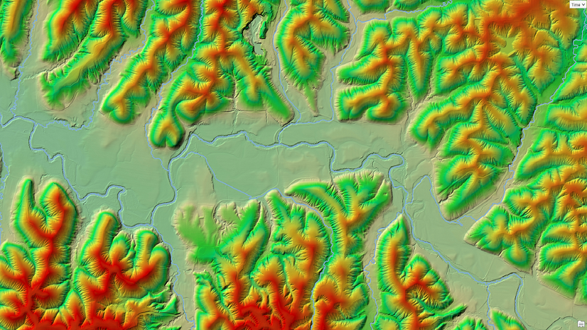
In 2010, the US Geological Survey (USGS) embarked on an ambitious mapping project to construct a high-resolution digital elevation model (DEM) for the state of Alaska. Dewberry, an Esri Gold Partner, recommended using interferometric synthetic aperture radar (InSAR) for the mapping. The elevation data for Alaska was captured during the summers of 2010 and 2012, and the data processing was complete by 2020—in total, a 10-year project. After completing the mapping, the next task that fell to the USGS was to use the five-meter-cell-size, InSAR-derived DEM to update the National Hydrography Dataset (NHD)—the “blue lines” on the topographic maps—from 2D geometry to 3D geometry. Thus, a product called Elevation-derived Hydrography (EDH) and the 3D Hydrography Program (3DHP) were initiated.

Since 2020, Dewberry, one of six USGS contractors, were tasked with updating more than 95,215 sq. miles (246,606 sq. km.) in 24 USGS Hydrological Units (Code 8) from NHD blue lines to 3DHP specifications (Figure 1). To accomplish this task, Dewberry GIS analysts turned to the available DEM manipulation and analysis tools contained in Esri’s Arc Hydro for ArcGIS Pro. Initially, using the InSAR-derived DEM, the GIS analysts approached the task using a classic hydrography feature extraction workflow, starting with (1) Identifying and Filling Sinks to condition the InSAR-derived DEM; (2) then using that conditioned DEM to construct the Flow Direction, Flow Accumulation, and Stream Definition rasters; (3) and vectorizing the Stream raster before; (4) smoothing the aliased lines; and (5) finally, adding 3DHP attribution.
The classic hydrographic line extraction portion of the workflow relied on the “D8 method” (Tarboton, 1997), which models flow direction from each cell to its steepest downslope neighbor. As a result, the D8 method produced a flow line network with (1) random flow paths through hydro-flattened lakes; (2) excessive terminal reaches in the watersheds; and (3) long stretches of straight lines for flow paths in low-relief areas, all of which are out of the USGS EDH specifications. While the D8 method and related algorithms direct water “downhill,” not all flow paths represent channelized, permanent flow, so other terrain indicators were needed to identify channelized vs. nonchannelized flow for 3DHP feature attribution. Alternative Arc Hydro workflows and tools were needed to satisfy these USGS/3DHP requirements.
From 2021 to 2024, the Esri water resources team and the Dewberry subject matter experts collaborated to construct four new Arc Hydro tools: two tools to facilitate flow network extraction and another two tools to facilitate flow line attribution from the Alaska InSAR-DEMs. The tools were designed to interact with each other in multiple workflow scenarios, while also remaining as stand-alone tools that could be integrated into non-3DHP workflows. Particular attention was devoted to (1) improving efficiency by eliminating processing steps; and (2) providing for scalability to accommodate large, USGS Hydrologic Unit Code (HUC) 8 Subbasin, 32-bit floating point elevation rasters of over 25 gigabytes in anticipation of high-density lidar-derived DEMs in the continental US.
Arc Hydro Flow Line Extraction solutions
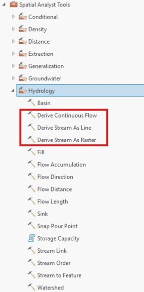
Two Flow Line Extraction Tools: Burn Flat Polygons into DEM (in Arc Hydro Tools Pro | Terrain Preprocessing | DEM Manipulation) places Artificial Path flow lines through the centers of waterbodies and rivers; and (2) Continuous Flow routing (Ehlschlaeger, C. R. 1989) was implemented in multiple Spatial Analyst tools (Figure 2) to direct flow in the upper reaches and more accurately depict flow through areas of low relief. These tools streamlined the Dewberry EDH workflow by eliminating manual editing of artificial paths through waterbodies and removing the need to fill sinks before flow line extraction. For a typical HUC8, GIS analysts realized a time/cost savings of 12–18 hours of manual editing.
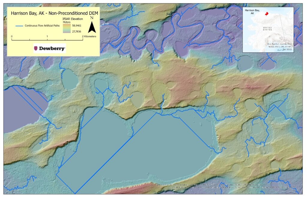
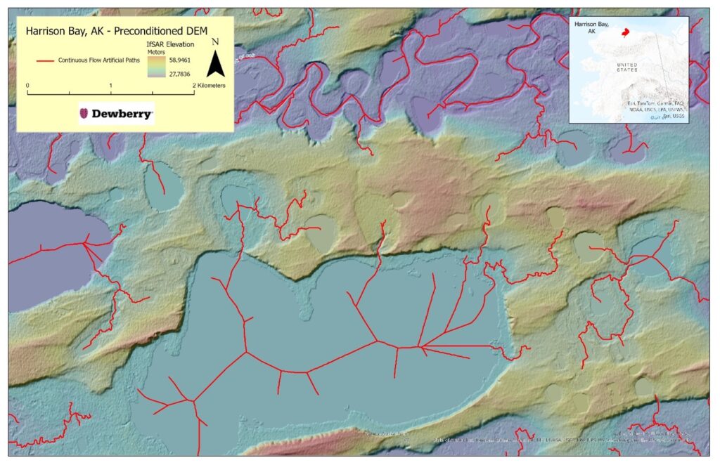
Tool 1: Burn Flat Polygons into DEM in the Dewberry 3DHP workflow is now the only tool required for preconditioning the InSAR-derived DEM, replacing the entire Fill Sinks workflow. Using the D8 method for flow line extraction results in random lines going through these flattened areas, while using the Continuous Flow, D-Infinity, and/or Multidirectional Flow methods, results in artificial paths hugging one shoreline or the other (Figure 3a). As artificial paths through the centers of waterbodies and rivers are a central component of the NHD/EDH cartography, neither extraction method resulted in artificial paths through the centers of these features without extensive preconditioning of the DEM or significant manual editing of the resulting flow lines. Now, preconditioning the DEM with one tool results in artificial paths in the centers of the waterbodies (Figure 3b).
Raster polygons are required for the tool, so in those cases where waterbody/river polygons are not supplied with the DEM, one of the new terrain tools, Geomorphon Landforms in Spatial Analyst (or Identify Flat Areas in Arc Hydro), can be used to extract Class 1 (flat areas) and Class 10 (pits and depression) polygons from the DEM—an example of how the new extraction and new terrain tools interact with each other. To derive the waterbody/river polygons, Dewberry uses either the Geomorphon Landforms tool (Spatial Analyst) or Identify Flat Areas (Arc Hydro) to extract the appropriate Geomorphon classes as input to the Burn Flat Polygons into DEM.
Tool 2: The Continuous Flow/Cost Routing algorithm (Ehschlaeger, C.R., 1989) was implemented in three tools in Spatial Analyst: Derive Continuous Flow, Derive Stream as Line, and Derive Stream as Raster.
These three related tools (Figure 2) all construct Flow Direction and Flow Accumulation rasters using the Continuous Flow algorithm (Ehschlaeger, C.R. 1989) without requiring the DEM to be preconditioned by filling sinks, saving several preprocessing steps. Using these rasters, a stream raster with a user-defined flow accumulation threshold is generated in a separate step. The Continuous Flow algorithm is also used in the Flow Direction and Flow Accumulation Using CF found in the Arc Hydro for ArcGIS Pro |Terrain Preprocessing toolset (Figure 4).

The Derive Stream as Line and Derive Stream as Raster tools each use the Continuous Flow algorithm; however, these tools require the user to define the flow accumulation threshold. Both the Line and Raster tools provide additional functionality by allowing the user to specify additional options for the Stream Designation method. As the Dewberry GIS analysts routinely remove Strahler Order-1 reaches less than 50 meters in length from the flow line dataset, using the Strahler Order option reduces manual editing and facilitates querying the flow line database.
Arc Hydro Terrain Indicator solutions
Terrain Morphology Tools 3 and 4: Geomorphic Landforms in Spatial Analyst is based on Geomorphons (Jasiewicz, J. and T.F. Stepinski, 2013) and classifies 10 common landforms, while BotHat in Arc Hydro is an image processing operation that derives from the “black top-hat transformation” (Rodriguez, F. et al. 2002) to identify valleys and incisions in the DEM. These tools were developed to work either individually, in combination with each other, or with other terrain indicators to help identify potential EDH channels in the DEM.
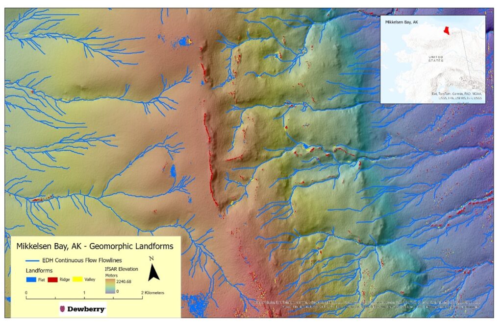
Tool 3: Geomorphic Landforms generates two rasters: one, the landforms raster, contains the 10 most common geomorphons; the other, the geomorphon raster, contains all 6,561 combinations of the 8 adjacent cells. To assist in attributing the Continuous Flow-derived flow lines, the Class 9 (valley) and Class 3 (ridges) are extracted from the landforms raster using the Extract by Attributes tool in the Spatial Analyst Extraction toolset (Figure 5). This derived raster is a strong indicator of reaches that are likely to be contained in channels (=valleys) and those that traverse through ridges that would require breaching. Similarly, the geomorphon landform Class 1 indicates a flat area, most likely a waterbody. The geomorphon Class 1 raster can be used in lieu of waterbody and/or river polygons for DEM preconditioning using the Burn Flat Polygons into the DEM tool, illustrating the interrelationship between the new tools.
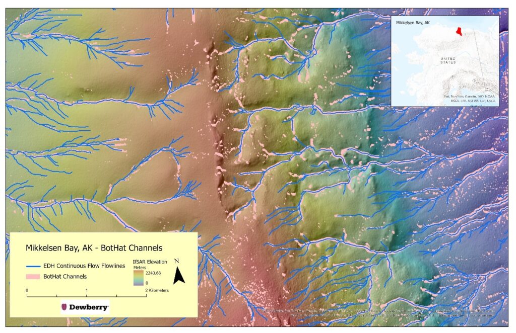
Tool 4: The BotHat tool in the Arc Hydro for ArcGIS Pro toolset generates a single BotHat raster with a user-defined processing window, while the BotHat Batch tool produces multiple BotHat rasters of user-specified processing windows and combines the rasters into a single output (Figure 6). This tool processes a typical Alaska HUC8 DEM of 3GB (22,500 x 32,000 cells) in under five minutes, which allows Dewberry to adjust the tool’s parameters and accomplish multiple outputs in a reasonable amount of processing time.
Looking to the future
Since 2020, Dewberry and Esri have been collaborating to develop these four tools and incorporate them into ArcGIS Pro 3.1 and 3.2. As these four tools are now mature, additional tools for refining the rasterized flow lines, identifying potential breaches, accommodating multiple flow paths through braided channels, and additional terrain morphology indicators are being developed. The current tools, though not specifically developed for USGS/EDH specifications, have streamlined workflows, decreased production time, and improved product quality in the Dewberry EDH program.
For more information, contact Al Karlin (AKarlin@dewberry.com) or Dean Djokic (DDjokic@esri.com)
About the Authors
Alvan “Al” Karlin, PhD, CMS-L, GISP, is a senior geospatial scientist at Dewberry, formerly from the Southwest Florida Water Management District (SWFWMD), where he managed lidar-related projects and Geographic Watershed Information System/Arc Hydro database development in cooperation with the Watershed Management Program. With Dewberry, he serves as a consultant on hydrology, topography, and imagery projects. He is currently the vice president of the ASPRS. In his spare time, he enjoys chasing after salamanders, frogs, lizards, and snakes, as well as growing tomatoes in his backyard garden.
Dan Djokic, PhD, is an experienced water resources professional with a Doctor of Philosophy (PhD) in Civil Engineering from The University of Texas at Austin. Dean is skilled in using Esri technology and is an expert in hydrology, hydraulics, solution architecture, and geographic information systems. He is the lead Arc Hydro architect and developer at Esri, contributing and mentoring within Esri’s water resources practice for more than 25 years.
Citations
Ehlschlaeger, C. R. 1989. “Using the AT Search Algorithm to Develop Hydrologic Models from Digital Elevation Data.” International Geographic Information Systems (IGIS) Symposium 89: 275–281.
Jasiewicz, J. and Stepinski. 2013. “Geomorphons – a pattern recognition approach to classification and mapping of landforms.” Geomorphology 182:147–156.
Rodriguez, F., E. Maire, P. Courjault-Rade, and J. Darrozes. 2002. “The Black Top Hat function applied to a DEM: A tool to estimate recent incision in a mountainous watershed (Estibere Watershed, Central Pyrenees).” Geophysical Research Letters 29(6): 9.1–9.4.
Tarboton, D. G. 1997. “A new method for the determination of flow directions and upslope areas in grid digital elevation models.” Water Resources Research 33(2): 309–319.
About the author