By: Jamie Patterson, GIS Manager, EPCOR and Ally Kennedy, Principal-Geospatial Utilities, Timmons Group
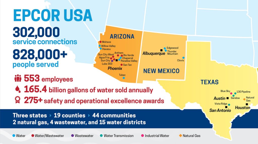
EPCOR USA Inc. (EPCOR USA) owns, operates, and builds water, wastewater, and natural gas infrastructure in Arizona, New Mexico, and Texas. As one of the largest private water utilities in the Southwest, it serves more than 800,000 people across 44 communities. EPCOR USA is an indirect, wholly owned subsidiary of EPCOR Utilities Inc. based in Edmonton, Alberta, Canada.
Managing Scale
For the better part of two decades, the Arizona-based GIS team has leveraged Esri products to deliver geospatial services to water and wastewater operations, engineering, and other functions of the US business. EPCOR USA’s portfolio covers a range of systems—including a large presence in the Phoenix metropolitan area with some of the fastest growing communities in the nation, wholesale water pipelines supplying portions of greater Austin and San Antonio, and small to medium sized rural communities across Arizona and New Mexico. Through organic development, system acquisitions, and new business ventures, EPCOR USA has consistently grown and evolved over the last decade. One of the key questions we face is—how do we continue to deliver high-quality geospatial services across an expanding footprint? In other words, how do we manage scale?
“One of the key questions we face is—how do we continue to deliver high-quality geospatial services across an expanding footprint? In other words, how do we manage scale?”
In 2020, EPCOR USA partnered with Timmons Group to assess our current GIS, gather program needs, and develop a future state plan with the primary requirements to
- Modernize the GIS platform with long-term success in mind.
- Fully migrate to ArcGIS Pro.
- Retain geometric network type functionality.
EPCOR USA continued to team with Timmons Group, an Esri Network Management Specialty partner, for the implementation of ArcGIS Utility Network. This included a full ArcGIS Enterprise platform upgrade with new architecture, including Portal for ArcGIS.
To minimize spatial distortion and align linear asset records with tax parcel boundaries and right of ways, EPCOR USA uses the coordinate systems adopted by its local jurisdictions—in most cases, State Plane coordinates. The datasets identified for migration to ArcGIS Utility Network fall within five State Plane coordinate system zones—two in Arizona, two in New Mexico, and one in Texas. Each mix of coordinate system and utility schema (i.e., water, wastewater, or non-potable water) triggered a new database. Accordingly, Timmons Group migrated EPCOR USA’s geometric network datasets into nine new Utility Network SQL databases. We leveraged a tenth database, coined “EPCORUSA”, to overcome the limitations of the fragmented datasets. For a multi-state view and ease of use with web applications, this read-only database contains three Utility Network schemas projected to a Web Mercator spatial reference. A single repository is useful for asset reporting and dashboard configurations that pull information from across the organization.

Migrating at Scale
In order to ensure our migration into Utility Network could be as seamless as possible, Timmons Group delivered ArcGIS Data Reviewer files that allowed EPCOR USA editors to navigate to and fix data errors. While we were not able to build out all our subnetworks from day one in Utility Network, this process got us a lot closer to that functionality. Given the large number of EPCOR USA systems, progress continues to complete subnetworks for all systems.
Esri solutions for water and wastewater were used as the basis for the data models for EPCOR USA. Following workshops with the GIS users and feedback from other end users like engineering and on-site crews, Foundation data models were customized to meet EPCOR USA’s specific business needs. The customized Water data model was used as the basis for the non-potable data model and then underwent several additional changes.
All the regions used the same data model for each utility (e.g., the New Mexico Water data model is the same as the Arizona Water data model) aside from coordinate systems. The Texas water transmission system also used the same water data model, plus the addition of several unique feature classes and non-spatial, related tables. The large wholesale water pipeline does not require heavy network edits and, therefore, was implemented without the network object itself.
The data was migrated from the source databases into the customized Utility Network asset packages with FME. Additional workbenches were created to QA the output of each migration and ensure the deployments of Utility Network would succeed. The output of these QA workbenches was reviewed by stakeholders prior to implementation to ensure all features migrated as expected.
Configuration
Attribute rules were configured to streamline editing as much as possible. These included calculation rules to populate fields based on intersecting polygons, ID generation rules, and modified rules from the Utility Network Foundation solutions. Validation attribute rules were also created to ensure high data quality. The combination of these attribute rules and Utility Network’s connectivity rules allows EPCOR USA to easily find data that needs attention, and therefore become more confident in our data quality.
Data editing was further streamlined with the configuration of group editing templates. EPCOR USA staff received training and guidance from Timmons Group on how to set these new template types and then configured them as needed. These templates allow staff to create many features, such as a hydrant with its laterals and valves, with very few clicks.
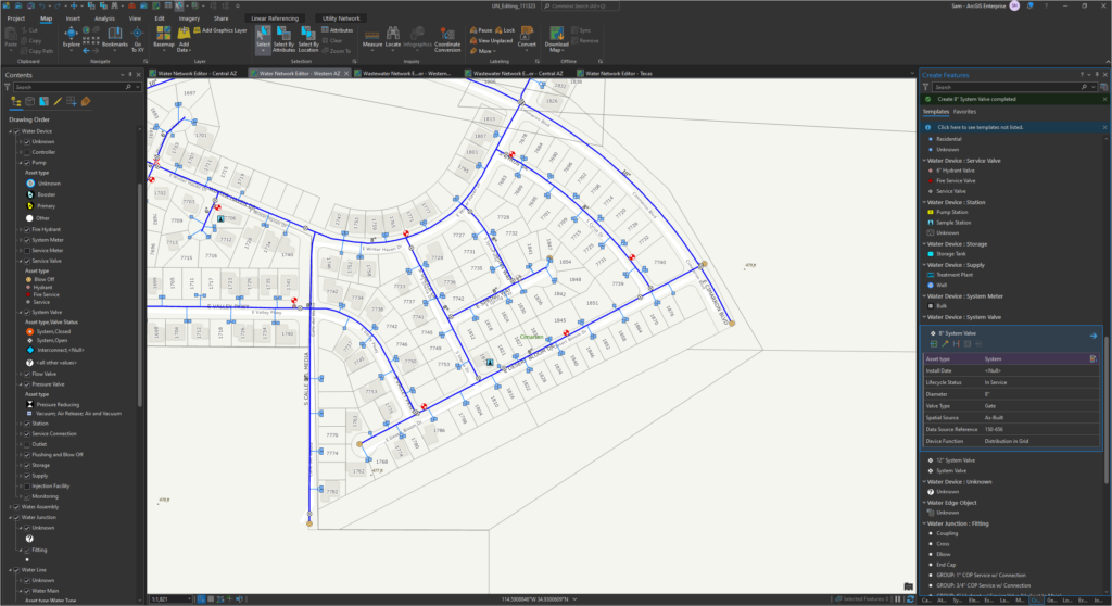
Following Timmons Group’s guidance, EPCOR USA pushed each editing map, including its editing templates, to Portal as map packages. This allows all our editors to work from common templates and easily receive new group templates as they are created.
The new editing tools, combined with branched versioning yield efficiencies compared to the previous traditional versioned workflow. Branched versioning also removed the occasional performance lags seen by users interacting with our most heavily transacted databases and eliminated the administrative overhead of scheduling compress and reindex jobs.
Integrations
Prior to this project, EPCOR USA’s Cityworks AMS implementation was using two domains, one for the Texas wholesale system and one for the regulated Arizona and New Mexico systems. Aligning the Texas data model with the other water systems allowed us to maintain the current asset configuration and asset work history within Cityworks, as both Texas and the rest of the network were published in the same feature service in the GIS. Iterative testing of both the Cityworks settings and the map used to publish the feature services was used to ensure that front-end users of Cityworks experienced as few changes as possible. EPCOR USA also undertook change management tasks so that Cityworks users would know what to expect. The result of the combined efforts of Timmons Group and EPCOR USA was a smooth Cityworks transition with minimal disruption to end user experience, despite the radically changed underlying GIS schema.
The project culminated with the GIS team leveraging Portal for ArcGIS to reinvent one of EPCOR USA’s most heavily used mapping applications. Developed by a third party, the previous application accessed geometric network content published from EPCOR USA’s ArcGIS Server instance. The new platform, developed in-house by our GIS staff with ArcGIS Web AppBuilder, delivers Utility Network content to users across the business.
Results
All the goals of the original project were completed; EPCOR USA fully migrated to ArcGIS Pro with ArcGIS Utility Network and minimal downtime.
Benefits gained from the project include:
- More efficient editing workflows
- Cleaner datasets and better quality control tools
- Richer data model, capable of tracking finer details
- Easier sharing of GIS content through a modernized enterprise GIS platform
Keys to our successful implementation include:
- Comprehensive planning from a long-term perspective
- Working with a trusted and qualified partner in Timmons Group to plan and execute a complex migration
- Finding a solution that meets the specific needs of our organization
We have a geospatial data management solution that can handle a large, varied, and expanding footprint and positions EPCOR USA to remain on the leading edge of GIS solutions.
Stay Connected with Esri’s Water Team
ArcGIS is an extensive information system that enables modernization of workflows with easy-to-use applications for the field and office. Strengthen your organization with smart water solutions that will increase efficiency and provide insight for decision-makers.
Visit the Esri Water Utilities web site for more information.
Learn more about network management.


