As a thought leader in the telecommunications and cable industry, I’ve devoted much of my career to using mapping technology for connecting people and organizations to what’s important in their lives. Over the past few years, I’ve focused my helping organizations, communities, and consumers overcome one of the most critical challenges of our time: bridging the digital divide. This endeavor, aimed at ensuring equitable access to broadband throughout the world, has been more than a professional journey; it has been a personal mission. Today, I want to share my insights into how WGI Geospatial’s innovative solutions have been instrumental in this quest, setting new standards for precision, efficiency, and sustainability in broadband infrastructure deployment.
In this blog I’d like to share a few thoughts regarding the work WGI Geospatial is doing. The following areas stood out to me while reviewing their latest ArcGIS Storymap, as they highlight the amazing capabilities their team is delivering to the telecom industry.
The Heart of the Matter: WGI’s Pioneering Role
WGI Geospatial stands out as an innovative leader in the effort to expand broadband access throughout the United States. I believe their tailored geospatial solutions have been revolutionizing the planning and deployment of extensive fiber and small-cell networks. By leveraging cutting-edge 2D/3D mapping technology, the team at WGI Geospatial has facilitated precise antenna placements, engineering, and utility detections, resulting in a dramatic streamlining of the management of telecom infrastructure.
The Power of 3D Visualization
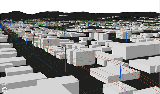
In our current era of telecom, the push for construction activity to expand high-speed internet to underserved and rural areas heavily rely on federal funding. Here, WGI Geospatial’s 3D mapping technology and visualization tools have proved invaluable for insightful collaboration. These tools allow teams to accurately measure the reach of high-speed services, while identifying gaps in coverage with unparalleled precision. This capability has been essential in expediting the provision of broadband services to rural communities and ensuring that the promise of connectivity is realized sooner rather than later.

Mapping Success: Beyond Numbers
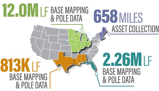
I think WGI Geospatial’s impact goes beyond the impressive statistic of 14+ million linear feet collected. It’s about how this data is leveraged in transforming the approach to rural broadband expansion. The comprehensive surveys conducted in diverse locations—from the Intracoastal Waterway in Lake Worth Beach, Florida, to multi-phase mobile Lidar collections in the Midwest—demonstrate how location intelligence and geospatial technology can redefine excellence in infrastructure projects. These efforts have facilitated the development of GIS datasets essential for leveraging mapping technology in designing telecommunication fiber networks with extraordinary precision.

Transformative Make-Ready Mapping Products
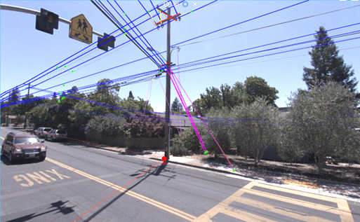
The efficiency and accuracy delivered to organizations by WGI Geospatial’s Make-Ready Mapping Products have been nothing short of transformative. I believe these products streamline the preparation of poles for new attachments, by providing a clear digital twin representation that accelerates the rollout process for stakeholders by bringing the field to the engineer. This innovative approach not only boosts efficiency but also minimizes environmental impacts and enhances safety standards across numerous teams.

Non-Intrusive Data Collection and 360° Coverage
WGI Geospatial’s adoption of terrestrial Lidar and UAS collection methods has offered a non-intrusive, yet comprehensive, data collection alternative enhancing both efficiency and safety. I like that the 360° coverage ensures that detailed views of the surroundings are captured every second along traveled routes, identifying potential conflicts or obstructions early in the make-ready, design, and construction phases. There were many times throughout my career where this kind of insight would have saved my team time, money, and frustration.
The Future Is Geospatial
I believe WGI Geospatial has underscored a critical lesson: the future of broadband expansion, and telecommunications infrastructure development, depends heavily upon location intelligence and GIS mapping technology. These combined resources not only deliver precision and speed, but also ensure the sustainability of our efforts to bridge the digital divide. It’s clear that as we move ahead, innovations like those from WGI Geospatial will play a pivotal role in shaping the telecommunications landscape, bringing the idea of universal broadband access closer to reality.

In conclusion, my experiences with WGI Geospatial have been both enlightening and transformative. Their technological prowess is revolutionizing the approach to telecom infrastructure development and plays a crucial role in addressing global broadband needs. Looking to the future, I believe it’s clear that embracing location intelligence and geospatial technologies will be key to overcoming challenges along the way to achieving our goals in telecommunications industry.
The path forward is undeniably geospatial, and with partners like WGI Geospatial, the industry is well-equipped to navigate the marketplace while ensuring high-quality and reliable service for all. This journey, though challenging and time consuming, reaffirms my personal commitment to bridging the digital divide and connecting people to what’s important in their lives. I look forward to sharing more resources leveraging the power of geospatial technology to connect society soon.
Resources
Learn more about WGI Geospatial
Take a look at their work: WGI Geospatial ArcGIS StoryMap
Learn more about Esri in Telecommunications


