Get Started with BIM and CAD in ArcGIS

Visualize and analyze BIM and CAD data with ArcGIS, the leading enterprise geospatial platform, to transform digital project delivery

Sign up to learn more

Seamlessly connect design and location data

Top AEC companies use ArcGIS for GIS and BIM collaboration, empowering connected construction workflows. Improve productivity, inform decision-making, and enhance coordination throughout your project life cycles.

Achieve comprehensive, sustainable planning

Capture details about existing conditions and predict outcomes

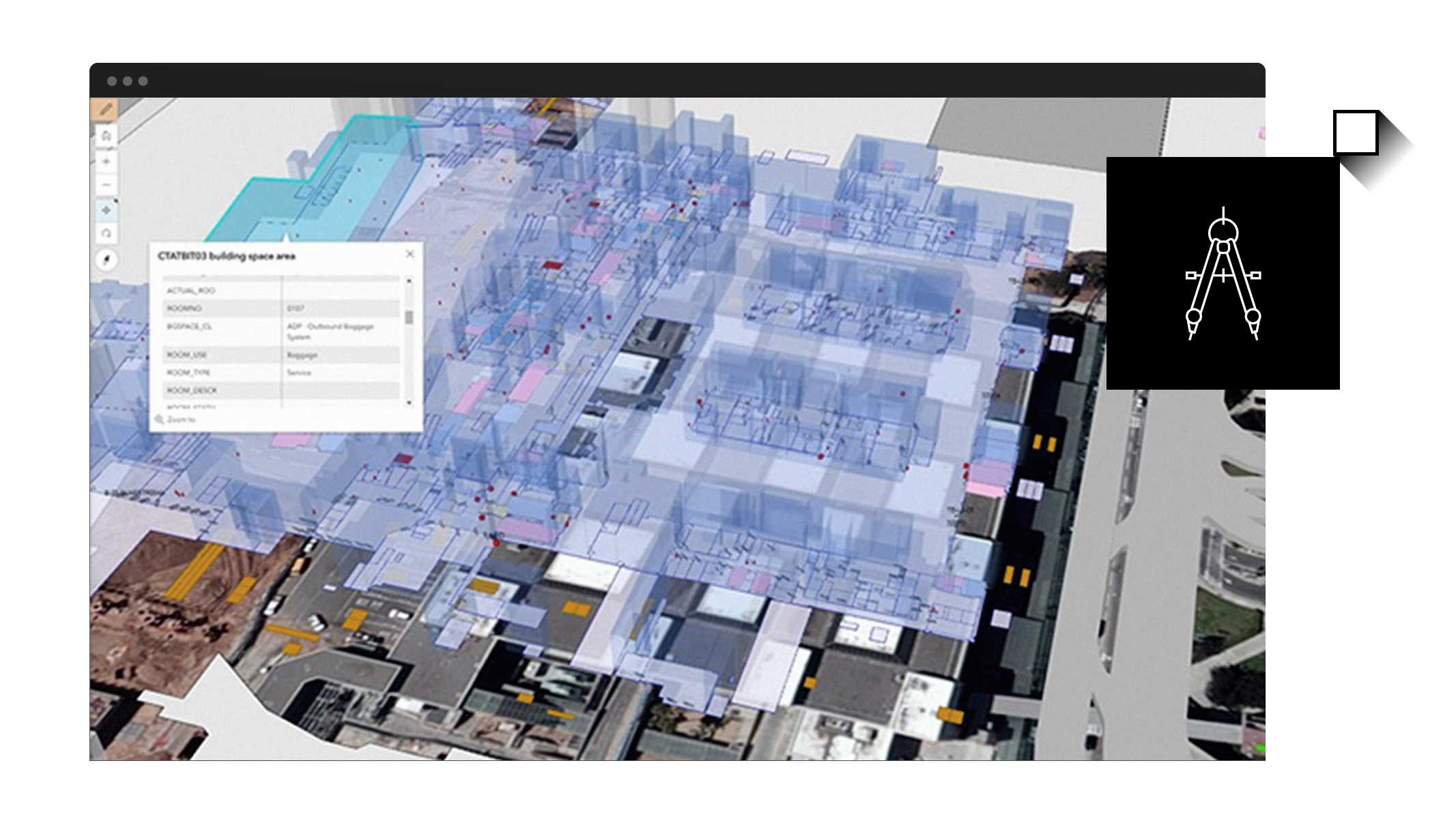
Combine BIM and CAD project data with authoritative, open, and ready-to-use content, including environmental data layers, to create dynamic, location-based visualizations.

Before projects begin, use these sophisticated maps and 3D models to identify prime locations, assess site suitability and risk, evaluate feasibility, or predict where specific permits are needed. Take a strategic approach and minimize environmental impacts.

Innovate with geography-driven design

Model and test scenarios for optimal outcomes

Perform comprehensive site analysis with ArcGIS to create detailed 3D models that highlight design restrictions and regulations. This ensures project feasibility, compliance, and sustainability.

Incorporate up-to-date details about natural and built environments—from terrain to power lines—into your designs for greater precision and improved collaboration among project stakeholders and teams.

Mitigate risk, build efficiently

Predict and prevent risk and keep projects on track

Give your teams the tools needed to build and access field maps, documentation, dashboards, and more. Support seamless coordination between build teams by monitoring progress, anticipating issues, and precisely locating where delays are or could occur.

Whether it’s a suburban subdivision or a nationwide infrastructure initiative, ArcGIS scales to meet the demands of any project, delivering a connected construction experience.

Operate with precision and resilience

Jumpstart operations with maintenance-ready data

Operationalize digital project deliverables as a foundation for asset and facility management, capital improvement planning, and real-time monitoring.

Augment BIM and CAD data from the entire project life cycle with geospatial context, improving accuracy and preventing data loss. Equip operations and maintenance teams with geoenriched tools to map and monitor assets, uncover opportunities, and improve emergency preparedness.

Buy ArcGIS for your team

Securely access and license ArcGIS anywhere, on any device

ArcGIS provides comprehensive capabilities for creating, managing, analyzing, and mapping geographic information. User types provide role-based access to ArcGIS capabilities through apps and services.

Start with core users

Creator

Access essential ArcGIS capabilities

Create and share maps and apps. Coordinate work with project stakeholders and teams. Manage members, groups, and content and automate workflows.

Buy now

Add field collaborators

Mobile Worker

Connect the office and the field

Collect and update data in the field. Receive work orders, view BIM documents, and create issues on or off-site with a common data environment.

Buy now

Add collaborators

Contributor

Review projects and make simple edits

View maps, apps, and content with access to multiple platforms, including Autodesk. Mark up and apply simple edits to project data for easier collaboration.

Buy now

Contact sales

Speak with a representative.

1-800-447-9778

7:00 a.m.–5:00 p.m., Monday through Friday (PT)

Chat now

Start a conversation online.

Send a message

Get an email response.