This year is shaping up to be one of the largest Esri User Conferences ever, and the amount of content available for utilities and utility network customers reflects this! We have put together this article to help you plan your schedule regardless of whether you will be joining us in-person or attending digitally.
Industry Flyers
Outline
- Expo
- Sunday, July 14
- Monday, July 15
- Tuesday, July 16
- Wednesday, July 17
- Thursday, July 18
- Additional Resources
Expo
The expo area is one of the most impressive places to visit during the user conference, and I recommend everyone spend at least a few hours wandering the aisles and taking it all in. With thousands of Esri staff and your peers you’d be hard pressed to find a better place or time to get even your toughest GIS questions answered! If you have a problem, you need help solving there are also hundreds of exhibitors, sponsors, and business partners waiting to talk to you who may have the solution you’ve been looking for. If you want to know more about who is going to be in the expo area, you can find all the details over on the expo page for the conference agenda. The expo area is open to the public at the following times:
- Tuesday, July 16 – 9:00 AM to 6:00 PM
- Wednesday, July 17 – 9:00 AM to 6:00 PM
- Thursday, July 18 – 9:00 AM to 4:00 PM
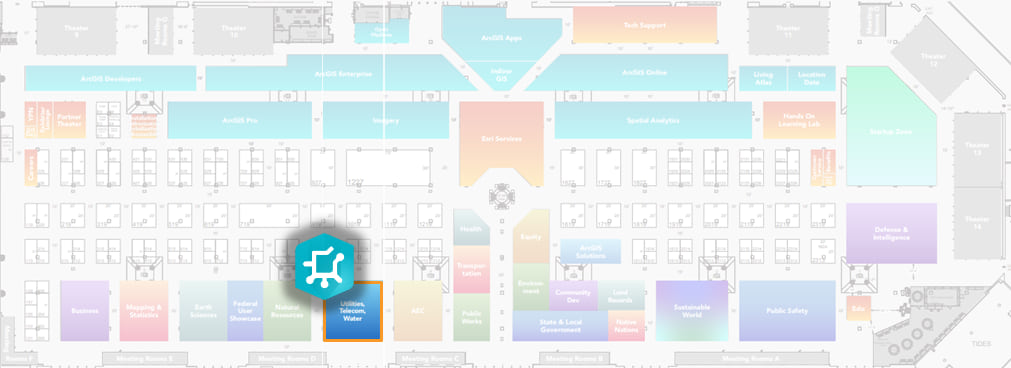
If you have any questions about the utility network, come by the utility network booth in the Utilities, Telecom, and Water area of the expo floor. The booth is located towards the front of the room, by the main doors, alongside the AEC and Natural Resources booths.


Sunday is typically a travel day for most attendees, and it’s a good time to pick up your badge early! While there is lots to do in downtown San Diego or the surrounding area, if you’re looking for things utility network or GIS related to do there are a few pre-conference activities happening.
Misc Activities
- 1:00 PM – 4:30 PM: Esri Water Utilities Meetup
- 9:00 AM – 3:30 PM: GIS Manager’s Summit
- 4:00 PM – 5:00 PM: Attendee Orientation
Social Activities
- 5:00 PM – 7:00 PM: GIS Managers Summit Social

The main activity happening on Monday is the Plenary! It’s a full day activity with a break in the morning to stretch your legs and refresh your coffee, with a longer break in the afternoon to grab lunch.
Main Activities
- 8:30 AM – 10:30 AM: Plenary Part 1
- 11:00 AM – 12:30 PM: Plenary Part 2
- 2:00 PM – 3:30 PM: Plenary Part 3
Social Activities
- 4:00 PM – 6:00 PM: Map Gallery Reception

Tuesday is the first day of the Expo, and the first day for presentations and workshops. There are also special interest group meetings and a social for utility customers who are looking to connect with their peers.
The team will be presenting introductory and advanced sessions on the utility network. If you’re still getting up to speed on the utility network and its capabilities, you should attend one or both these sessions and come prepared with your toughest questions!
Regardless of your familiarity with the ArcGIS Utility Network you should consider attending the Utility Network Essentials presentation by the ArcGIS Solutions team. They will be introducing the concept of an essentials data model, which is going to change the way that many customers and partners tackle projects and data modeling.
Demonstrations and Workshops
- 11:30 AM – 12:15 PM: ArcGIS Data Reviewer: Tips and Tricks for Validating Water Utility Networks
- 11:30 AM – 12:15 PM: ArcGIS Field Maps: Taking Utility Networks to the Field
- 11:30 AM – 12:15 PM: ArcGIS Field Maps: Configuring Smart Forms for Utilities
- 11:15 AM – 12:00 PM: Utility Network Migration Package – The New and Easier Way to Migrate
- 4:30 PM – 5:15 PM: Web and Mobile Apps that will Modernize Your Network Management
Technical Presentations
- 8:30 AM – 9:30 AM: ArcGIS Solutions: Utility Network Foundations
- 10:00 AM – 11:00 AM: ArcGIS Utility Network: An Overview
- 2:30 PM – 3:30 PM: ArcGIS Utility Network: Advanced Network Management
User Presentations
- 10:00 AM – 11:00 AM: Pipeline Network Data Management
- 10:00 AM – 11:00 AM: Managing Vertical Assets
- 1:00 PM – 2:00 PM: Measuring GIS Return on Investment
- 2:30 PM – 3:30 PM: Using ArcGIS Enterprise in the Cloud
Misc Activities
- 11:30 AM – 12:30 PM: Electric Distribution SIG
- 11:30 AM – 12:30 PM: Pipeline SIG
- 11:30 AM – 12:30 PM: Telecommunications SIG
Social Activities
- 6:00 PM – 9:00 PM: Electric & Gas Utilities and Telco Social

Wednesday is when the conference kicks it into high gear for utility network customers. There are many activities to choose from for every hour of the day, but make sure you take time out to relax and enjoy yourself. Maybe take a break on one of the terraces overlooking the bay? Wander the expo hall and see what the partner community is up to? Visit the utility network booth to tell us your plans for the utility network?
Demonstrations and Workshops
- 11:30 AM – 12:15 PM: ArcGIS Field Maps: Configuring Smart Forms for Utilities
- 1:00 PM – 1:45 PM: ArcGIS Maps SDKs for Native Apps: What’s New and the Road Ahead
- 11:30 AM – 12:15 PM: ArcGIS Utility Network: Troubleshooting with Log Analysis
Technical Presentations
- 10:00 AM – 11:00 AM: ArcGIS Pipeline Referencing: An Overview
- 1:00 PM – 2:00 PM: Essential Network Diagram Workflows
User Presentations
- 8:30 AM – 9:30 AM: Practical Applications of GIS for Electric Transmission
- 10:00 AM – 11:00 AM: Water and Sewer Management with ArcGIS Utility Network
- 10:00 AM – 11:00 AM: Modern Network Management Implementations for Electric Utilities
- 1:00 PM – 2:00 PM: Modern Network Management Planning for Electric Utilities
- 1:00 PM – 2:00 PM: GIS Solutions in AEC: From Digital Twins to Facility Asset Management
- 2:30 PM – 3:30 PM: Gas Utility GIS Integrations
Misc Activities
- 11:30 AM – 12:30 PM: Electric Transmission SIG
- 11:30 AM – 12:30 PM: Water Utilities SIG
Social Activities
- 5:30 PM – 7:30 PM: Developer Social
- 6:00 PM – 9:00 PM: AEC Social
- 6:00 PM – 9:00 PM: State & Local Government Social
- 6:00 PM – 9:00 PM: Water Utilities and Water Resources Social

Things start winding down on Thursday, so it gives you a chance to slow down and reflect on how you can apply what you’ve learned at the conference to your work for the rest of the year. If you missed the introductory or advanced utility network presentations, we will be doing repeats of both sessions on this day.
There’s also the Thursday Night Party at Balboa Park, so make sure to pick up your wristband!
Demonstrations and Workshops
- 11:30 AM – 12:15 PM: ArcGIS Field Maps: Taking Utility Networks to the Field
- 12:10 PM – 12:30 PM: Planning for Utility Network Migration: A Brief Overview
- 1:00 PM – 1:30 PM: 5 Additional Tips to Ensure a Successful Utility Network Implementation
Technical Presentations
- 10:00 AM – 11:00 AM: ArcGIS Utility Network: An Overview
- 4:00 PM – 5:00 PM: ArcGIS Utility Network: Advanced Network Management
User Presentations
- 8:30 AM – 9:30 AM: Seamless GIS Migration to the Cloud
- 10:00 AM – 11:00 AM: Practical Applications of GIS for Electric Distribution
Misc Activities
- 11:30 AM – 12:30 PM: Digital Twin SIG
- 11:30 AM – 12:30 PM: Electric Small and Medium Sized Utilities SIG
- 11:30 AM – 12:30 PM: Gas Utility SIG
Social Activities
- 5:30 PM – 10:00 PM: Thursday Night Party

There are some repeat sessions on Friday morning covering some interesting non-utility network topics like GeoAI and ArcGIS Online, but after that you should consider attending the closing session to hear Jack and Esri’s directors’ recap everything that happened during the week.
Main Activities
- 10:30 AM – 12:00 PM: Closing Session

If you’re looking for additional resources to check out before or after this year’s user conference we recommend checking out the following links:
If you’re looking for information about the utility network, the Helpful Utility Network Links community document has links to all the most commonly referenced online resources for the ArcGIS Utility Network.
Check out one of the following learning series if you want to explore industry specific collections of utility network related articles, videos, and presentations.
- Learn ArcGIS Utility Network for Electric Utilities
- Learn ArcGIS Utility Network for Gas and Pipeline
- Learn ArcGIS Utility Network for Water Utilities
Use the ArcGIS Utility Network video channel on the Esri Video site to access a curated selection of videos covering utility network content from product releases, webinars, or even past conferences.
You can use the Esri Proceedings site to access the proceedings (slides and videos) from past Esri conferences.


Commenting is not enabled for this article.