Today’s utility network projects come in all shapes, sizes, and levels of complexity. Over the past year as a large number of electric, gas, and water networks have rolled into production, telecommunication companies have also begun an exploration into the utility network’s capabilities which are supported by a range of powerful solutions developed by our partners. During this time, one of the biggest requests for enhancements we’ve received from partners, distributors, and customers has been the addition of nonspatial objects to the network topology for modeling and trace analytics.
Manage network features at all scales and resolutions
One of the primary advantages of the utility network is its ability to model your network at all scales and resolutions. The utility network is already known for its flexibility in adapting to the infrastructure and business requirements that exist when modeling network features. With the release of ArcGIS Pro 2.6 and ArcGIS Enterprise 10.8.1, we’ve taken this capability a step further with the introduction of nonspatial junction and edge objects.
In case you missed it at the plenary during this year’s Esri User Conference, Deilson da Silva, showcased this new capability to work with dense communication systems where a large number of features share a common location.
Network configurations such as fiber or electric underground networks can contain a very dense array of geographic features that have the potential to overwhelm the user experience. The introduction of nonspatial objects allows for another level of granularity.
When modeling fiber strands, for example, it is necessary to model each individual strand, since a customer may be served by only one or two of these. Representing thousands of fiber strands as spatial features could prove to be problematic, as you would have to work with stacked geometry, negating the value of spatial representation and potentially impacting performance.
The release of nonspatial objects in ArcGIS Enterprise 10.8.1 provides the ability to build schemas for underground and fiber network features such as fiber buffer tubes and electric ducts without the need for features with geometry on a map. For example, you may have a fiber cable that contains thousands of network strands as well as a room containing a large number of disparate pieces of equipment all located in the same geographic location.
The new nonspatial object tables support the representation of junction (point) or edge (line) network features for any domain in your network, including the structure domain. Previous challenges are now surmountable as we can now manage and analyze all of these easily in a traceable utility network.
None of the geometry. All the functionality
Nonspatial objects enable you to represent a large number of features in a small geographic space. While these have no geometry, you are still able to work with and analyze these as you would any other network feature.
In more complex networks it can be a challenge to model multiple levels of granularity using conventional geometric features. To address those challenges, nonspatial edge and junction objects can be utilized to provide high-resolution model details without the programmatic cost of very large scale geometric features. When you use nonspatial objects, network rules are configured to support connectivity, structural attachment, or containment associations which model relationships with and inherit geometry from other network features.
In Figure 1 below you can see an example of this in action. This displays twelve nonspatial edge objects records being used to model fiber strands that are associated through a containment association with the selected spatial communications line feature on the map.

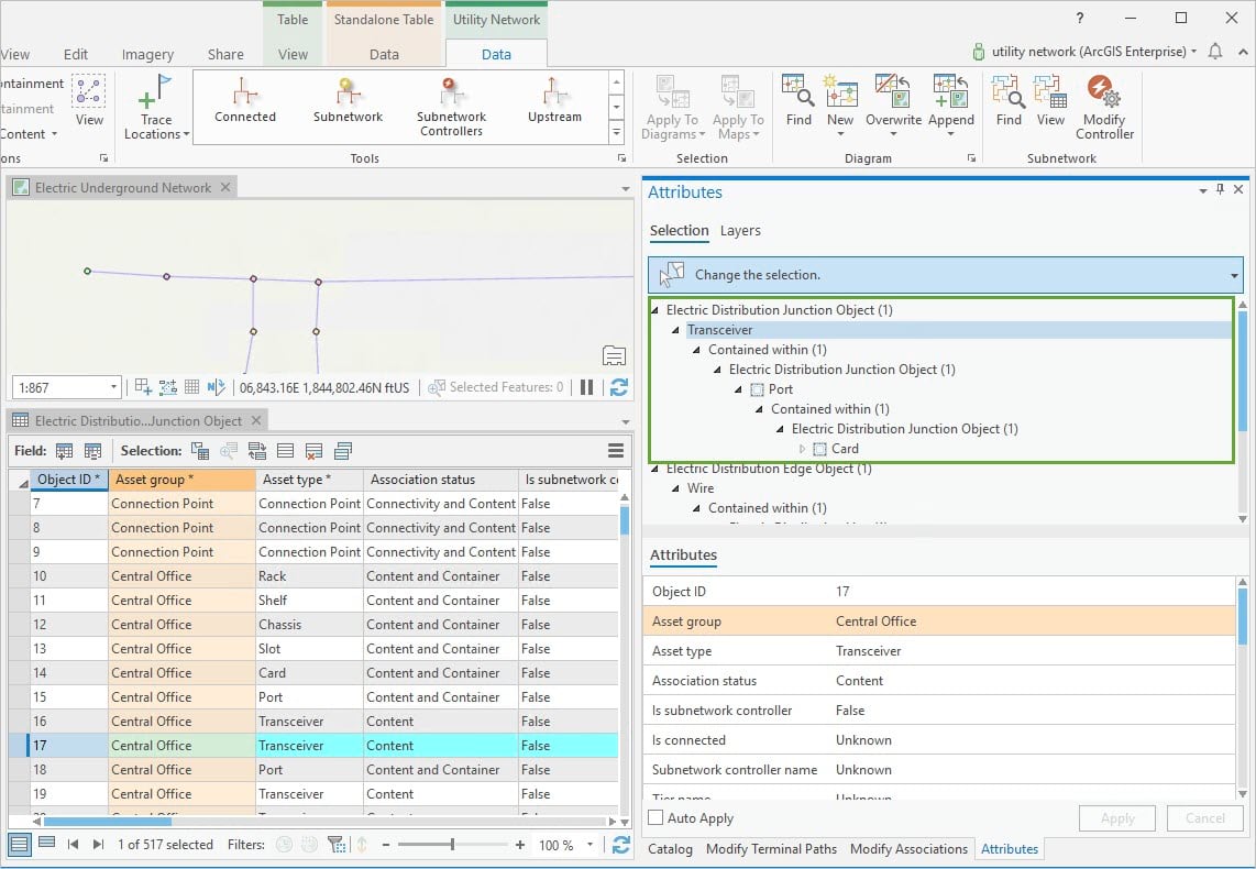
Complex network features such as communication routers, multiplexers, ports, and transceivers can also be modeled using nonspatial junction objects (as shown below in Figure 2) enabling engineers to have network representations for features that occupy common geographic regions.

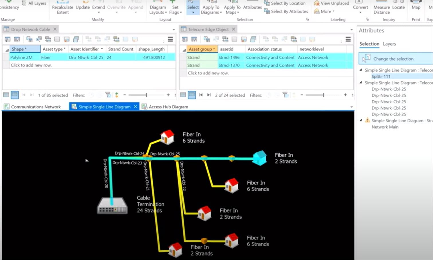
Nonspatial edge and junction object tables have all the capabilities of spatial features. In addition to network elements in the nonspatial object; network attributes, or categories can be appended to those object tables. You can also add any additional attribute fields, domains, or even contingent attributes as needed. Additionally, custom network diagram templates can be authored to enable visualization of nonspatial objects through a simple single line diagram like that shown below.

Nonspatial objects can be populated via the editor interface or attribute rules in ArcGIS Pro starting with 2.6 as well as Runtime or through the web with ArcGIS Enterprise 10.8.1.
As utilities modernize, networks have become exponentially larger and more complex. Communication and distributed energy systems have the potential to benefit from the capabilities provided nonspatial objects as well as the other enhancements made with the recent release which include changes to error management and dirty areas, the trace framework, and subnetwork management.
As more utilities continue to adopt the utility network and take advantage of these recent updates, it will be really interesting to see the various solutions that evolve.
Visit us on GeoNet and let us know how you plan to implement nonspatial junction and edge objects into your business.


Commenting is not enabled for this article.