Today, we release a new version of ArcGIS Urban and we are excited to announce the highlights of the February 2023 release. This time, we present to you 4+1 workflows that we have unlocked with just one new feature:
- Visualize and present your planning scenarios with key metrics
- Create compelling StoryMaps explaining the impact of planning scenarios
- Build a custom application and share it with stakeholders for self-exploration
- Combine plans and projects to analyze long-term vs. short-term activities
The largest new feature in this release is a new way to create web scenes from scenarios in your plan to jumpstart effective storytelling, guided presentations, and self-exploration for stakeholder engagement.
Let’s have a look at some of the workflows that are now possible.
Visualize and present your planning scenario with key metrics
Each scenario in a plan contains buildings, surfaces, and parcels based on your system of record and proposed changes. To make it easier for your stakeholders to quickly understand the impact of a scenario, you can now use color ramps to show changes in metric values, such as residential units or jobs. For parcels, you can also choose visualizations based on building and zoning parameters.
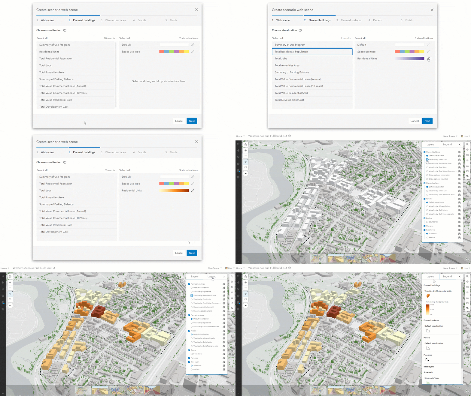
The layer visualizations with the selected color ramps are included in the web scene as sub layers that can be switched on and off. As a result, each web scene comes out looking exactly how you want it to look and ready to be used in your next presentation.
Create compelling StoryMaps explaining the impact of planning scenarios
As with the city web scene, the web scenes you create from your scenarios can now be used directly in other apps such as StoryMaps. This new workflow enables you to rapidly create multiple stylized web scenes of alternative scenarios, then add them each to a story for comparison. StoryMaps are an effective medium for communicating complex topics because you can provide additional context to guide the reader.
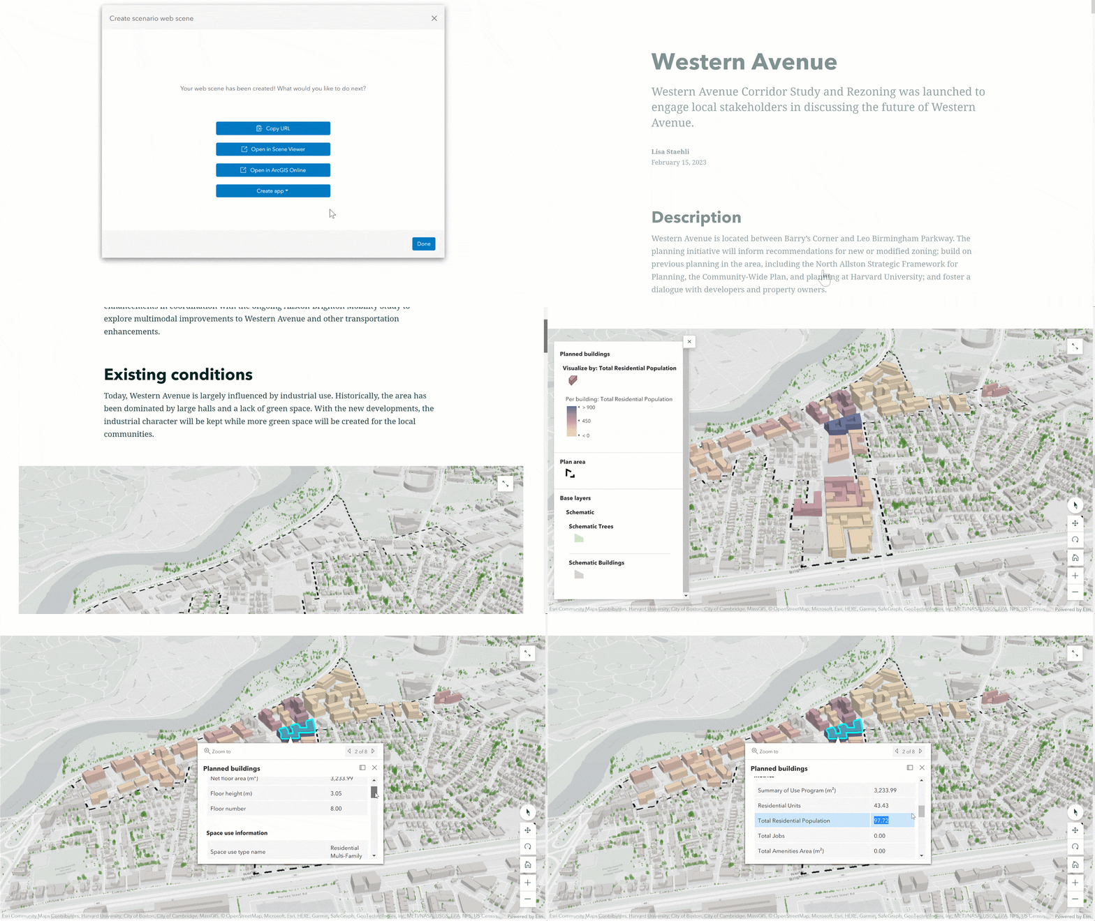
This workflow can also be combined with the layer visualizations by creating multiple versions of the web scene highlighting different topics. With scenario web scenes, a StoryMap can be created within minutes instead of hours – to streamline your stakeholder engagement.
Build a custom application and share with stakeholders for self-exploration
Next to the layer visualizations, we also added dedicated pop-ups to the layers in the web scene. For example, the plan area pop-up shows aggregated dashboard metric values for the scenario, while the parcel pop-up also shows regulations and building parameters for the selected parcel.
Both the pop-ups and layer visualizations are designed in a way that web scenes created from plan scenarios can be used not only for guided presentations, but also for stakeholders to explore the information on their own.
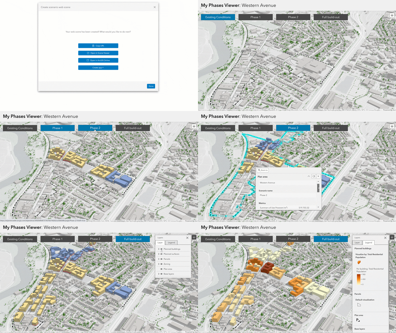
The web scene can be shared directly with stakeholders, embedded in a web page, StoryMap or a custom app. You can easily navigate in the scene and find relevant data about a proposed development that allows you to make data-driven decisions.
Combine plans and projects to analyze long-term vs. short-term activities
Another new feature of the scenario web scene is the ability to export planned buildings together with projects in the study area. The combination of both information allows for long-term and short-term considerations.
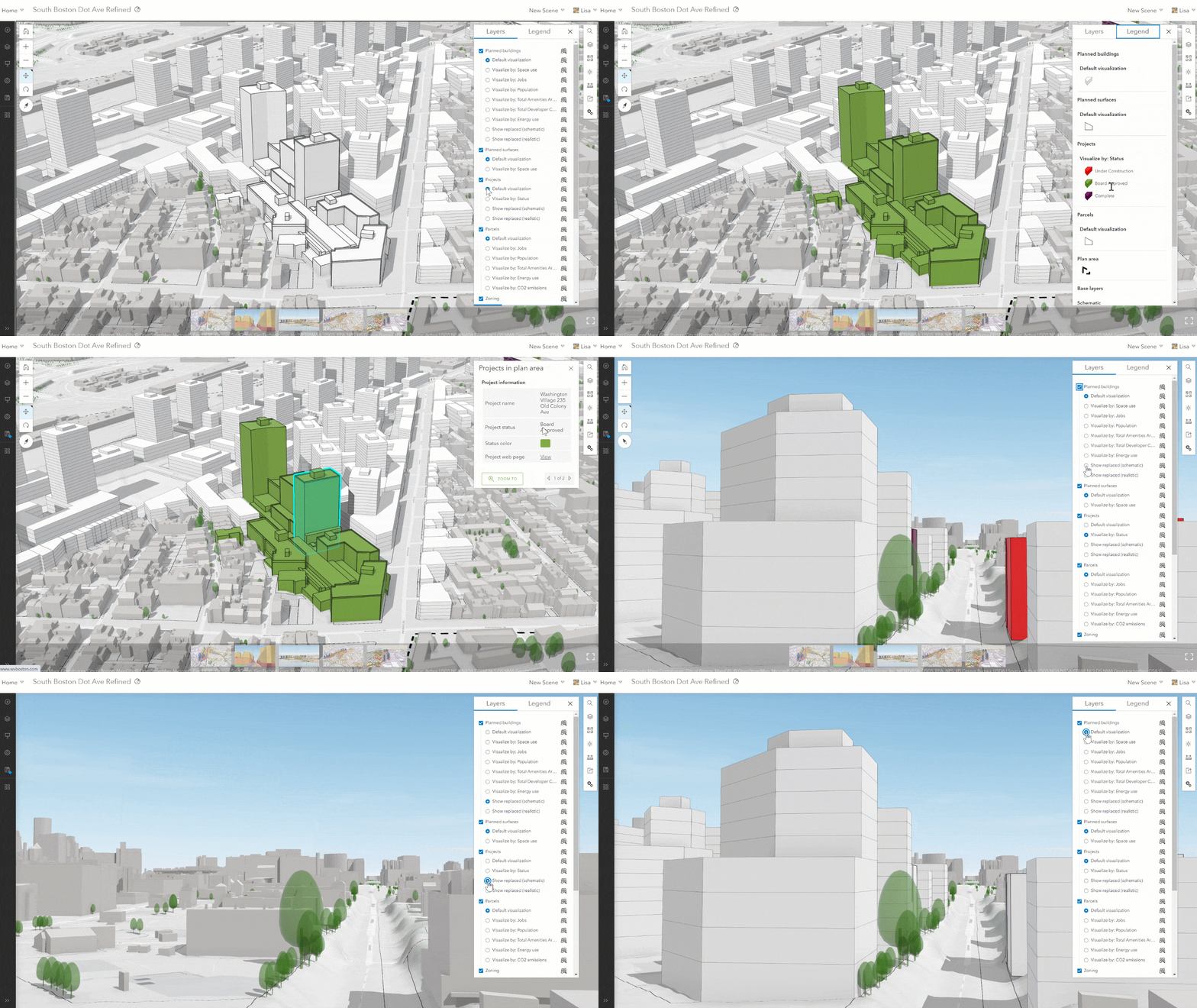
On top of that, the new scenario web scene also has the ability to compare your planning proposal against existing conditions. The replaced existing buildings and trees can be visualized compared to the planned buildings as well as to the projects. This gives a clear picture of what will change compared to the status quo.
BONUS: Automatically retrieve and replace an existing scenario web scene
A capability that we recently introduced for the city web scenes has now also made it into the plan editor. You can now replace existing web scenes created previously from your scenarios directly through the UI in Urban to avoid unnecessary duplicates being created each time.
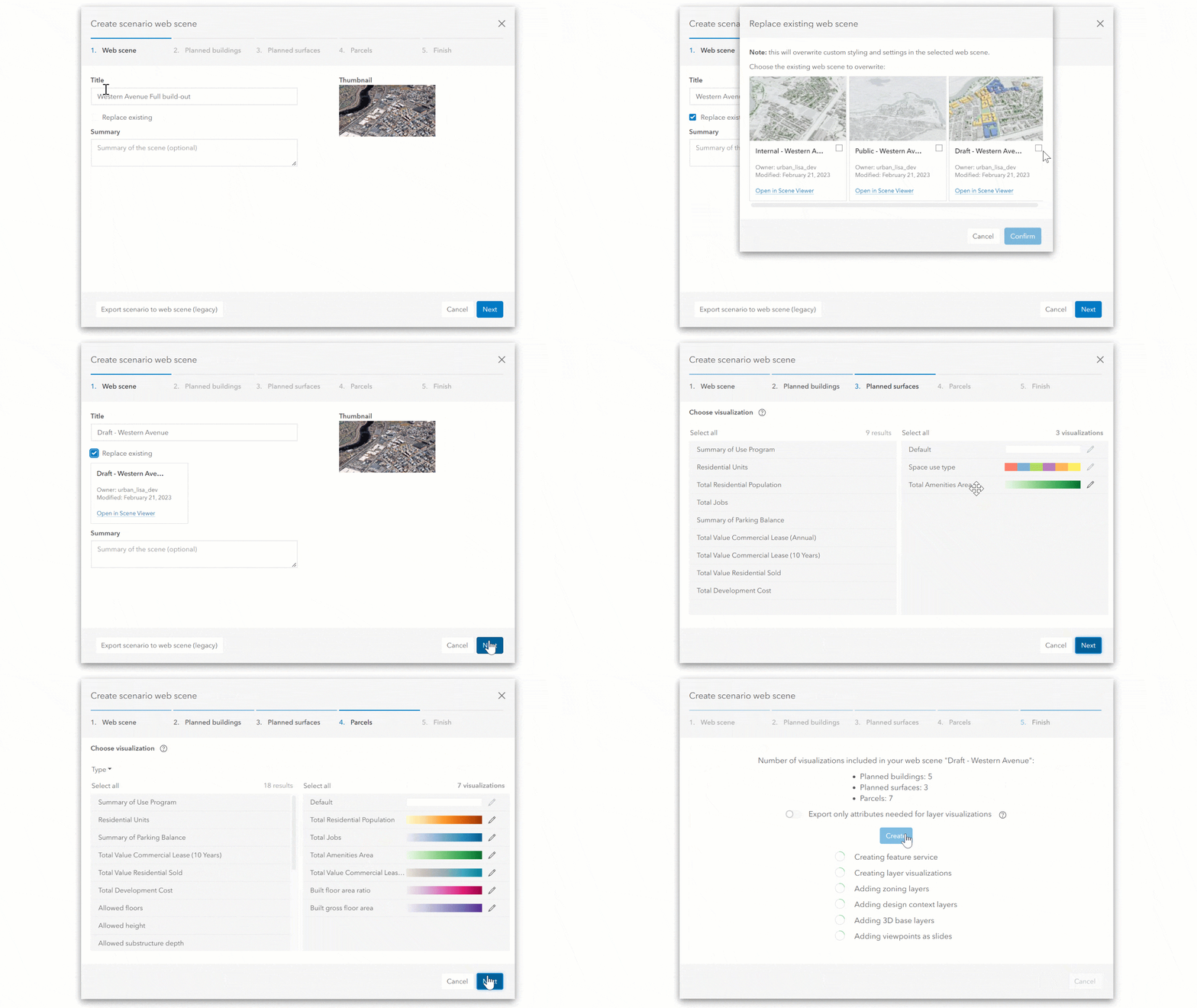
But not only that – when selecting an existing web scene, the layer visualizations from the previous web scene are used to prepopulate the dialog. This allows you to create an update of your scenario web scene faster and you have the guarantee that layers will be visualized the same way as before.
Learn more
Do you want to learn more about the February 2023 release of Urban? For instance, how you can access suitability results throughout the plan editor or that we now display zoning and space use legends in read-only plans?
Check out the release notes to read all the details about the features, improvements, and bug fixes released in the latest version of Urban.
Watch the webinar from March8th 2023 to see all these workflows in action. You can find the recording here.
Want to see these new features live in ArcGIS Urban? Feel free to schedule a demo with our team.
Additional resources
- Check out the ArcGIS Urban Resources StoryMap for a complete overview of all the available ArcGIS Urban resources.
- Sign up for the ArcGIS Urban Newsletter to stay up to date.
- Help improve Urban and join our ArcGIS Urban User Lab to be contacted for user research and testing.

Article Discussion: