The 2024 Esri User Conference, set for July 15-19th in San Diego, CA, is just around the corner! We are excited to share a lineup of ArcGIS Urban technical sessions and user presentations designed to inspire your use of GIS for urban planning.
ArcGIS Urban Sessions
In these sessions, our team of experts walk you through best practices, tips and tricks, and real-world examples.
ArcGIS Urban: An Overview
Tuesday, July 16 | 2:30-3:30 PM PDT | Room 3 | SDCC and Wednesday | 10:00-11:00 AM PDT | Room 30 AB | SDCC
This session is perfect for getting started with ArcGIS Urban. It covers the basics of modernizing traditional planning processes with 3D scenario modeling and project tracking.
ArcGIS Urban: Creating the Planning Digital Twin
Wednesday, July 17 | 2:30-3:30 PM PDT | Room 30 AB | SDCC
What is a digital twin? And what is the role of GIS in implementing digital twins in your urban planning work? Join us to learn how ArcGIS Urban helps you build a foundation for your planning digital twin.
ArcGIS Urban: Applying Urban Planning Workflows
Wednesday, July 17 | 4:00-4:45 PM PDT | Expo Demo Theater 5 | SDCC
See how ArcGIS Urban can be applied in diverse contexts with real-world examples, from conducting fiscal impact analysis to tackling housing issues and environmental planning challenges.
Related Sessions for ArcGIS CityEngine and XR
Enhance your planning projects with advanced procedural modeling, building information modeling (BIM) integration and extended reality.
ArcGIS CityEngine: An Overview
Tuesday, July 16 | 10:00-11:00 AM PDT | Room 9 | SDCC and Wednesday, July 17 | 4:00-5:00 PM PDT | Room 30 AB | SDCC
Learn about advanced modeling of detailed cityscapes and how to effectively combine ArcGIS CityEngine with ArcGIS Urban for a comprehensive approach from early-stage planning to detailed development scenarios.
Wednesday, July 17 | 10:00-10:45 AM PDT | Expo Demo Theater 14 | SDCC
Learn about the ArcGIS mission-critical platform and solutions that support you in planning sustainable, equitable, and desirable neighborhoods that meet the modern needs of residents.
GIS-BIM Integrations for Project and Operations
Wednesday, July 17 | 1:00-2:00 PM PDT | Ballroom 30 AB | SDCC
Aimed at architecture, engineering, and construction (AEC) professionals, this session explores how to visualize, track, and gain value from diverse project datasets, integrating ArcGIS with design and operation workflows.
ArcGIS: XR (Extended Reality)
Thursday, July 18| 1:00-2:00 PM PDT | Ballroom 20 BC | SDCC
Discover Esri’s extended reality (XR) technology, including augmented reality (AR) and virtual reality (VR). See firsthand how GIS data, when integrated with Unity and Unreal Engine, creates immersive urban planning experiences on devices like Microsoft HoloLens and Oculus Quest.
Stop by the ArcGIS Urban booth located at the Community Development Area of the showcase to learn more about Urban XR!
Special Interest Groups (SIGs)
Attend the Planning and Community Development SIG: Implementing Modern Housing and Zoning Policies to learn more about how GIS is being used to implement a modern approach to housing and zoning reform. This event will be held on Wednesday, July 17, at 11:30 AM-12:30 PM PDT in Room 4 at the SDCC.
User Presentations
User presentations are designed to inspire. These sessions, focused on urban planning, aim to offer valuable insights and strategies for integrating ArcGIS Urban and other ArcGIS solutions into your workflows.
Preserving your Community by Planning for the Future
Tuesday, July 16 | 8:30-9:30 AM PDT | Grand Ballroom Salon 11 | Marriott
The Greater Salt Lake Municipal Services District has developed a repeatable workflow that other communities can adopt, using a digital twin created with ArcGIS Urban, Site Scan, and RTK drones.
3D Planning to Create Sustainable Communities
Wednesday, July 17 | 2:30-3:30 PM PDT | Grand Ballroom Salon 4 | Marriott
Oslo’s new high-rise strategy requires analyzing impacts on wind and sunlight, prompting a shift from 2D maps to 3D models. They’re also creating a city-wide 3D mesh. See how integrating a 3D mesh with wind and shade studies can benefit urban planning projects.
How to Evaluate Green Space and Address Climate Change Mitigation
Thursday, July 18 | 8:30-9:30 AM PDT | Room 29 B | SDCC
Hiroshima University, Osaka Metropolitan University, and the DDOT Urban Forestry Division present on the value of simulation models. See how they leveraged them to analyze the distribution of green space across communities with ArcGIS CityEngine, ArcGIS Pro, and ArcGIS Survey123
Visualizing Data and Improving Stakeholder Decision Making with Precision
Thursday, July 18 | 10:00-11:00 AM PDT | Grand Ballroom Salon 6 | Marriott
Learn how to streamline access to data for community and economic development with a presentation from the Montana Community Planning Platform (CPP). Then, hear case studies from Morrisville and Wake Forest, North Carolina; Lewistown, Montana; Downtown Dubai; and Glen Ellyn on how to leverage your existing investment in GIS as a foundation for a digital twin.
Additional Information
While you’re exploring the showcase floor, make sure to visit us at the Community Development Area. Our team will be there to answer any questions you have, offer personalized demos, and discuss the latest updates and features of ArcGIS Urban and ArcGIS CityEngine.
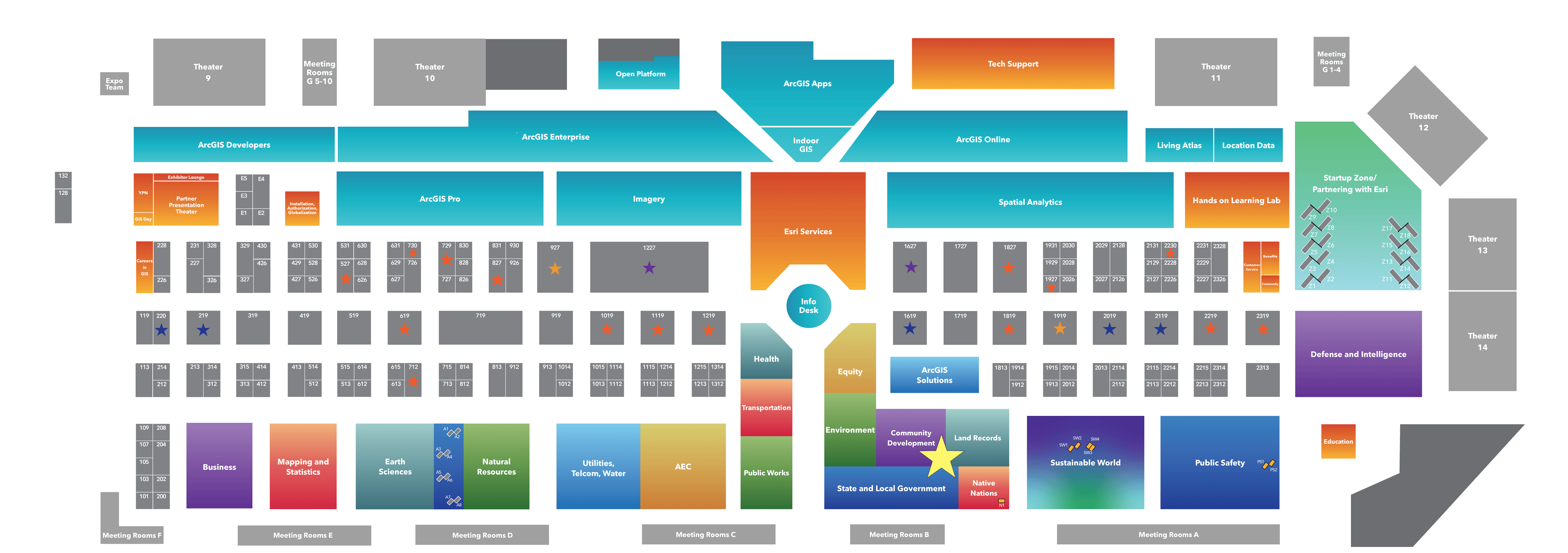
For an interactive guide to the showcase, refer to the Esri UC Event Map. Make sure to download the Esri Events App to keep your agenda and a mobile map accessible on your device.
Expo Hours:
Tuesday, July 16: 9:00 AM – 6:00 PM
Wednesday, July 17: 9:00 AM – 6:00 PM
Thursday, July 18: 9:00 AM – 4:00 PM
Urban XR
Get the chance to try out Urban XR using the VR headset by visiting the ArcGIS booth. This immersive experience allows you to step into virtual reality and explore urban planning scenarios in a more interactive and engaging way. It’s a great way to get a firsthand look at how different elements of urban design will feel and function in a real-world setting.

Article Discussion: