Happy Earth Day!
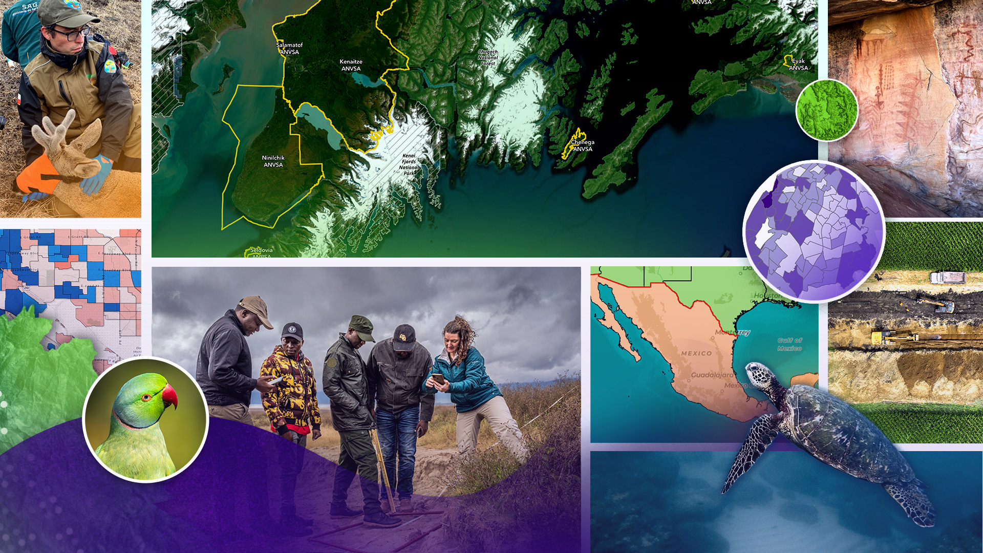
Monitor elephant habitat in Tanzania. Map landslide damage with drones in Nepal. And explore the seascapes of San Juan Island National Historic Park through place-based storytelling.
The 2024 ArcGIS StoryMaps Competition, Storytelling for a better world invited you and storytellers globally to build a story about the world you want to see. And you delivered—with stories from 58 countries, in 10 different languages, and about a diversity of local and global challenges.
As we celebrate the planet, Esri’s StoryMaps team and our guest judges are honored to recognize the competition winners—champions of wildlife, healthy people and habitats, sustainable communities, rich cultural heritage, and data-driven decision-making for everyone.
What stories took home the top honors? Find out in our announcement video below.
What techniques and topics made the winning stories…well…the winners? Read on for the answers and insights from the guest judges in each category.
Winners and student winners by category—including grand prize
- Digital humanities and popular culture
- Health and safety
- Humanitarian and disaster response
- Nature and physical science
- Planning and infrastructure
Special awards
- Storytelling with maps innovation award
- Community choice award
Just want to dive in and read the stories? No problem—we’ve got you covered. Browse the 2024 ArcGIS StoryMaps Winners collection for the winning stories and storyteller bios.


Last year, Esri invited five organizations to select the winners of the 2024 ArcGIS StoryMaps Competition, including the grand prize award winner and student winner. The grand prize awards recognize stories that display excellence in storytelling techniques, GIS and ArcGIS StoryMaps implementation, and an innovative approach to the competition theme.
Thank you to the guest judges—the International Union for Conservation of Nature (IUCN); Old Dominion University (ODU) Center for Geospatial Science, Education, & Analytics; San Bernardino County Department of Public Health; Stanford University Libraries Map and GIS Team; United Nations High Commissioner for Refugees (UNHCR)—for sharing your time and expertise with our storytelling community.

Digital humanities and popular culture are inherently interdisciplinary—and so are maps and GIS. Spatial information offers powerful ways to visualize, analyze, and interpret the world around us, historically and contemporarily. Discover the winner and student winner in the Digital humanities and popular culture category selected by Stanford University Libraries Map and GIS Team.

Braceros across the United States – Mexico border: A Mexican farmworkers’ journey by Latinos Heritage Conservation

Braceros Across the United States-Mexico Border—part of the Abuelas Project—honors the approximately 5 million skilled Mexican workers who addressed the U.S. labor shortage during World War II. Latinos Heritage Conservation told us: “(we) submitted this story to demonstrate how technology can center community voices and humanize history through impactful storytelling via mapping, such as those of braceros.”
And the Stanford University guest judges gave the organization high marks.
“We chose the Braceros Across the United States - Mexico Border story submission for its exceptional design and storytelling. It effectively combined graphic elements, personal anecdotes, interactive features, and richly detailed archival materials to create an engaging narrative that resonates with contemporary relevance. The use of black and white photos paired with vibrant accents set a powerful visual tone, while the thorough research and cited sources added depth and credibility. Personalized vignettes coupled with compelling call-to-action conclusions, made it not just a visually appealing work but also an emotionally stirring and intellectually robust piece—truly exemplary in its execution and impact.”

Interpreting Brownstone Canyon with the use of GIS by Ruzena “Zena” Zatko, University of Nevada, Las Vegas
Zena Zatko—a federal archaeologist and graduate student at the University of Nevada, Las Vegas—created this research-focused story to engage both academics and the general public in archaeology.
For the Stanford University guest judges, the story achieves that goal and much more.
“The Interpreting Brownstone Canyon with the use of GIS student story submission stood out for its innovative use of mapping features and immersive storytelling techniques, effectively integrating images, maps, and references. The presentation was notably clean and compelling, showcasing a deeply researched narrative rooted in the specificity of place. We appreciated this story’s commitment to decolonization in archaeology and anthropological best practices like multivocality and community-based outreach, thereby offering a rich, respectful account that would not have been as impactful without this interactive format.”

When it comes to health and safety, location matters. And not all locations are created equal. Geographic information and tools connect us with health and safety resources—and ensure that health and safety providers can locate us. Beyond location basics, GIS empowers communities to pinpoint vulnerable or at-risk populations, understand infrastructure capacity, allocate critical resources, and more. Discover the winner and student winner in the Health and safety category selected by San Bernardino County Department of Public Health.

Tucson Equity Priority Index: A data-informed approach to community investment by Laura L. Sharp and Ellie Hammond, City of Tucson
Ellie Hammond and Laura Sharp entered the ArcGIS StoryMaps competition to demonstrate how visual storytelling can make complex topics like social vulnerability engaging and comprehensible. The story, they shared, “underscores the role of geographic information in connecting communities with essential health and safety resources, while addressing disparities in access and infrastructure.”


What GIS and storytelling techniques turned numbers into a compelling story? These are the little things that made a big difference to our San Bernardino judges:
- The maps are visually striking, easy to navigate, and well-aligned with the story.
- The consistent colors and well-labeled pop-ups make complex data more digestible.
- Slider maps and interactive elements enhance engagement.
- Detailed use cases demonstrate real-world impact and practical applications.
- And the story ends with a strong call to action, inviting readers to explore and use the data.
Advancing accessible healthcare in Boston by Jacqueline Powers, Tufts University School of Medicine
Jacqueline Powers—a graduate student at Tufts University School of Medicine—says that “health is inherently spatial: from the spread of an outbreak to understanding health disparities geographically to picking a site for a new community health.” And in her winning story, Jacqueline uses census tract data and spatial analysis to pinpoint where a new community health center would have the most impact.
"This entry stood out for its practical application of GIS to solve a critical health equity challenge—a clear example of how spatial storytelling can drive meaningful change.” —San Bernardino County Department of Public Health

In local communities around the globe, individuals and families face both unexpected and systemic challenges from hunger to homelessness. And disaster takes many forms—conflict, job loss, climate impacts, and more. Geospatial stories can visualize the impacts of a disaster event, track the event over time, and help organizations make important decisions about how to help. Discover the winner and student winner in the Humanitarian and disaster response category selected by UNHCR, the UN Refugee Agency.
Drone-based aerial mapping of landslide: Change analysis and volume calculation of debris by Dinesh Lamichhane, Nepal Flying Labs Team
Dinesh Lamichhane—a geomatics engineer and GIS specialist with Nepal Flying Labs—leverages drone technology for disaster response. His winning story highlights the ways in which high-resolution UAV imagery can revolutionize landslide detection, damage assessment, and recovery planning.
“The story about the Ghyapche landslide in Nepal was wonderful at illustrating how advances in geo-spatial technology enhance our ability to understand landslides, their risk to communities, and design effective ways to mitigate the risk.” —UNHCR

The climate puzzle: Mangroves as the key piece by Vaidehi Patel, University of Guelph

Vaidehi Patel is a MSc student in Population Medicine: Epidemiology at the University of Guelph. Vaidehi joined the competition after completing a cohort of the Community Conservation, Data Visualization, and Map externship between The Nature Conservancy and National Geographic Society.
The climate puzzle was her first geospatial project, which makes her grand prize showing and the reaction from the judges all the more remarkable.
“The story about mangroves was particularly great at showing, through photos and maps, the importance of mangrove ecosystems on communities around the world, from Florida, to Nigeria, to Colombia, to Malaysia. It was a great way of using GIS and the ArcGIS StoryMaps platform to tell this story about our shared humanity.” —UNHCR
"It weaves together local, national, and global case studies, showing the real-world impacts of mangrove loss—flood risks, pollution, and public health concerns—while keeping the storytelling clear and accessible. The maps and multimedia elements were well-integrated and used to enhance, not distract from, the story. Most of all, it clearly embodied the theme of Storytelling for a Better World, with a compelling narrative that was both engaging and informative. It stood out among all entries—student or professional—for its excellence.” —San Bernardino County Department of Public Health

How can technology support conservation success? Wildlife biologists use camera traps; cartographers leverage satellite imagery; and students capture data with drones.
Stories shows how the technology is used, who it impacts, the local communities it supports, and the conservation outcomes it facilitates. Discover the winner and student winner in the Nature and physical science category selected by IUCN.
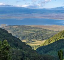
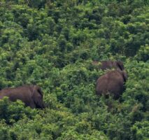
Charting a path to human-elephant coexistence in Tanzania by Katy Teson, Elizabeth Naro, and Sadikieli Joseph, African People & Wildlife
"At African People & Wildlife, we’ve seen the power of GIS to drive lasting change by putting data collection and decision-making in the hands of local people." —Katy Teson, Elizabeth Naro, and Sadikieli Joseph
The winning story shows how communities in Tanzania—supported by a vast network of partners—are using GIS to address human-elephant coexistence and strengthen habitat connectivity. Featuring the stunning photography of Marcus Westberg, this story highlights the people on the frontlines: local people working every day to protect both wildlife and human livelihoods.
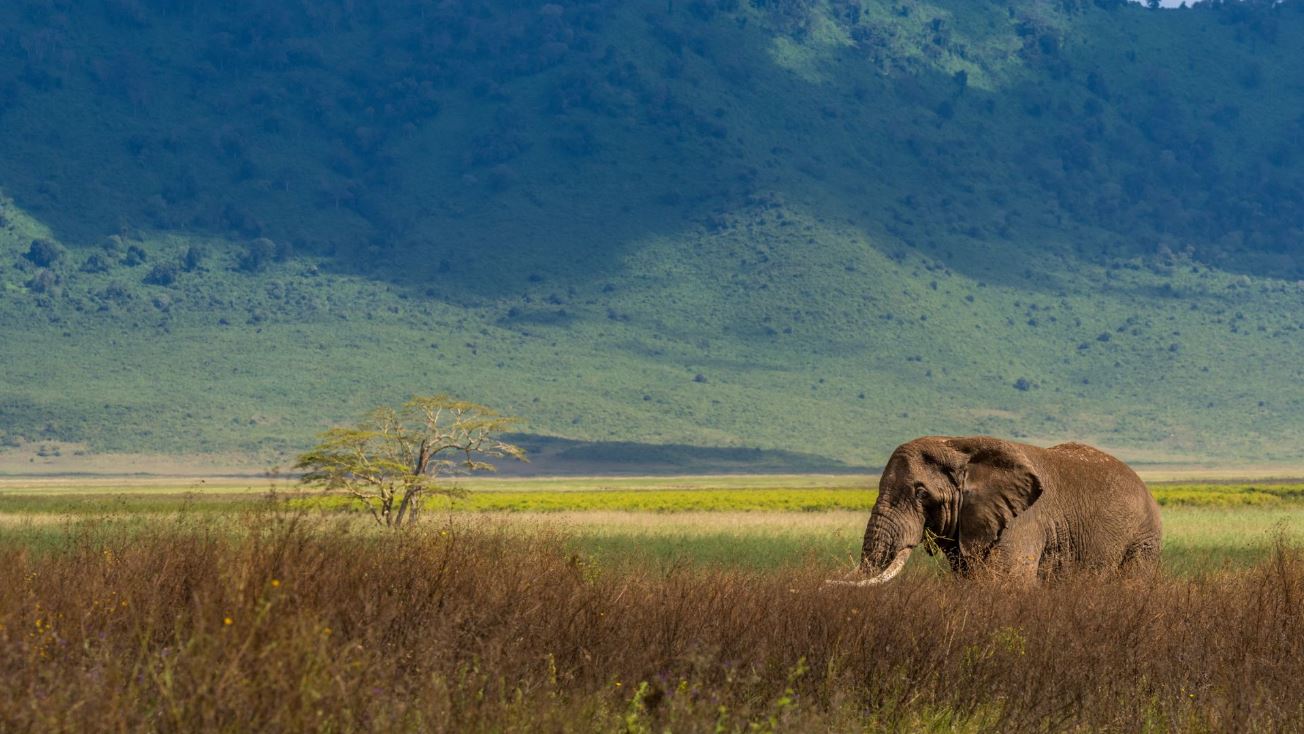
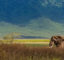
"The entire story is visually appealing, they have many options for interactivity including audio, video, photos, and maps. They also told the story well by starting at the macro level and zooming into the micro level where you can then place yourself at the center of the story. It was an added bonus that they designed infographics paired with real-life images of the application. A top submission for sure!" —IUCN
Crossing nets by Ona Santisteban Uribarri, Université Grenoble Alpes

Ona Santisteban Uribarri, a first-year biology student, uses an effective and unexpected storytelling technique in Crossing nets. The story of bycatch, a threat to sea turtles, is told from the perspective of the turtle.
Passionate about conservation and the ocean, Ona aims to: “use technology to raise awareness and foster collaborative efforts between scientists, fishers, and communities to protect these incredible creatures and their marine ecosystems.”
"This story was incredibly effective at incorporating different storytelling components and had a writing style that is understandable to technical and non-technical audiences. Another standout aspect of this story is that it is easily approachable to a younger audience—as tested by an IUCN employee and his daughter!" —IUCN

Planners, community leaders, and other problem solvers wrestle daily with countless questions designed to better our neighborhoods, regions, and the world. What are we doing to prepare our cities for extreme heat, flooding, and climate change? Where should we make investments to rebuild aging infrastructure in a way that is fair, equitable, and forward thinking? Discover the winner and student winner in the Planning and infrastructure category selected by Old Dominion University.
Breaking point: The state of Tribal forestry today by Intertribal Timber Council and Ecotrust
Intertribal Timber Council, established in 1976, is a nonprofit nation-wide consortium of Indian Tribes, Alaska Native Corporations, and individuals dedicated to improving the management of natural resources of importance to Native American communities. Ecotrust works in partnership from California to Alaska toward the vision of a more just, prosperous, and climate-smart future.
Together, they created a powerful interactive story that presents the current state of U.S. Tribal forestry management through local voices.

“The compelling integration of video, audio, maps, and infographics artfully brings attention to the critical issues surrounding tribal forest management. By incorporating powerful stories from tribal communities, this story effectively highlights both the challenges they face and the unique opportunities for sustainable management of these vital resources. Not only does this story showcase exceptional technical skills but also demonstrates a deep respect for the communities and environments at the heart of the story. We applaud the creators for their ability to communicate a complex array of interconnected issues with clarity and empathy.” —ODU
Bridging economy and ecology: Martin County Ditch No. 28 Nutrient Treatment Train by Emma Dorn, University of St. Thomas, and Matt Haken, Dordt University
The Martin County Ditch No. 28 Nutrient Treatment Train story opens in Fairmont, Minnesota, where drinking water flows from the Fairmont Chain of Lakes. The story builds as local partners develop a plan to replace an aging drainage system before it negatively impacts water supplies. The storytelling team, Emma Dorn and Matt Haken, told us: “Our story exemplifies how geospatial technology can bridge the gap between technical engineering datasets and public understanding by transforming complex infrastructure plans into an interactive, user-friendly digital experience.”
The collaborative efforts throughout the community and the story-building process impressed the judging team from ODU.
"The innovative use of images, maps, GIS data, and 3D graphics brings to life the impactful collaboration between agencies, landowners, and the City of Fairmont. This story exemplifies the power of teamwork in addressing crucial infrastructure challenges and safeguarding essential water resources. By taking a clear and thoughtful approach to highlighting this successful partnership and its positive outcomes, this story demonstrates skill in both technical mapping and effective storytelling.”


The Storytelling with maps innovation award presented by Esri’s StoryMaps team recognizes excellence and creativity in leveraging the ArcGIS StoryMaps features and integrating GIS products into a story.
There were many deserving stories for this award, and selecting just one winner was no easy task. In the end, it was the subtle artistry of Discovering San Juan Island’s natural diversity: Ecosystems of San Juan Island National Historical Park by Claire Crawbuck, Sarah Dolan, Micah Stailey, and Zak Woods of the U.S. National Park Service that won us over.
The story follows storytelling best practices with solid structure, navigation points, and beautiful photos. You can hear seabirds. And, yes, there are 3D scenes of the best island views.
Add in hand-drawn illustrations for separators and throughout the story narrative.

And consider the extensive and unique use of media actions—to engage and educate readers. At times, the map actions just offer a little context or a different view of a scene. Other times, the map actions offer a choose your own adventure into plants and wildlife species hidden from plain sight—but available through a simple click.
Each author of the winning story may accept a voucher ($250 value) for an Esri Technical Certification Exam and build their storytelling skills. Thank you to the Esri Training team for supporting the competition winners.

On February 12, 2025, Esri announced the 2024 ArcGIS StoryMaps Competition finalists and invited you and readers worldwide to vote for your favorite story. Over 7,200 individuals cast their votes!
Drum roll…
And the Community Choice Award goes to National Huemul Corridor: Public-private collaboration for the protection of the southernmost deer in the world and its habitat by Ingrid Espinoza, Lorena Valenzuela, and Liliana Guzmán with Fundación Rewilding Chile.
Are you ready to become our next Storyteller of the Year?
Visit the ArcGIS StoryMaps Competition website on July 14, 2025, to discover the new competition theme and get started.


Article Discussion: