For over fifteen years, FROX GmbH – Die IT Fabrik, a Silver Esri partner, has been developing innovative software solutions for digital surveying and mobile Geographic Information System (GIS) data acquisition. With a diverse client base of over 450 customers—including government agencies, infrastructure firms, environmental organizations, and utility providers—frox excels in delivering high-precision measurement tools for critical infrastructure.
To meet the wide range of rigorous requirements from this diverse audience, frox has developed a suite of digital surveying and mobile GIS applications including FX Smart, FX Reality, FX Collector, and FX Survey. The digital field book, FX Survey, provides precise on-site measurement and data capture through integration with a wide range of high-precision Global Navigation Satellite System (GNSS), Totalstations, Computer-Aided Design (CAD) plans, GIS data, and seamless integration with the back office.

The challenge: tackling a complex codebase and ArcGIS Engine’s upcoming retirement
Frox has been innovating in the survey and engineering software industry for over fifteen years, but started to face technical challenges typical of codebases that have evolved over several years. A traditional, monolithic software architecture began to pose challenges for maintenance, updates, and innovation. Furthermore, with the upcoming retirement of its software’s underlying GIS technology, ArcGIS Engine, approaching in March 2026, engineers at frox seized the opportunity to update.
Their goal was to transition to an architecture with a smaller footprint for lightweight applications designed for modern mobile devices and rugged tablets. Frox also aimed to use a developer kit that supported the latest high-performance layer types within the ArcGIS ecosystem, particularly for the integration of vector tile basemaps. It had to build performant and consistent applications that would run seamlessly in both online and offline environments. Finally, frox needed flexible, self-contained deployments that would allow applications to be deployed side-by-side on devices, simplifying ongoing maintenance and management.

The solution: modernizing with Esri’s ArcGIS Maps SDKs for native apps
To meet the challenge, frox chose Esri’s ArcGIS Maps SDKs for Native Apps to modernize its solutions and align with the latest software development trends, tools, and patterns. With existing expertise in .NET and C#, the frox development team naturally selected the ArcGIS Maps SDK for .NET. This decision enabled frox to realize several key benefits of the SDK, including a modern 64-bit architecture and support for the latest Microsoft .NET application development platform. This choice also enabled seamless integration with its existing Continuous Integration and Delivery processes, saving the time required to re-implement them. The modern, asynchronous design of the API, along with support for .NET features such as nullability, enabled the team to build applications that are more responsive and robust. Comprehensive support for the .NET Multi-platform App UI (.NET MAUI) desktop and mobile cross-platform framework were also crucial to frox’s decision to use ArcGIS Maps SDK for .NET. These features enabled it to use the same mapping SDK for other mobile surveying and GIS applications that run on Android and iOS.
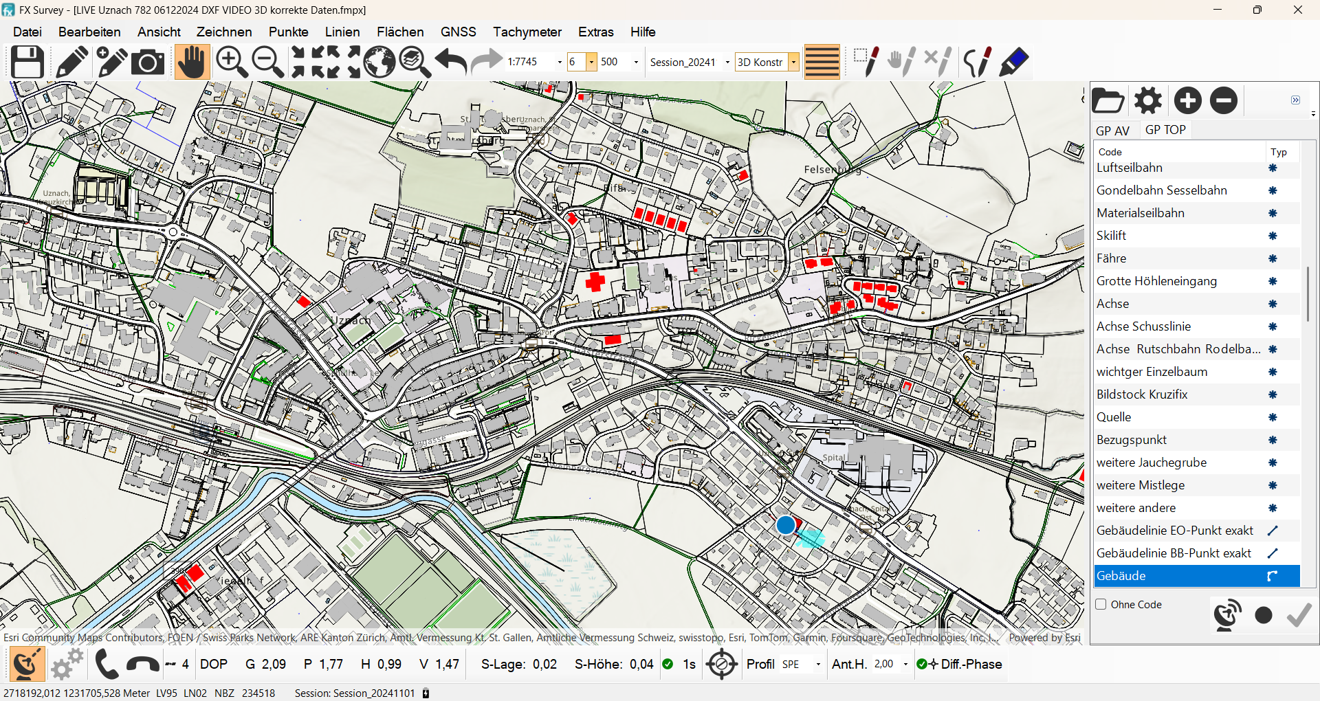
 software interface displaying a map with plotted points, lines, and a photograph.")
The Native Maps SDKs provide common API patterns for working with online and offline data. Frox leveraged this capability to support both online and offline scenarios, ensuring resilient and secure data access in the field, allowing mobile workers to continue their tasks even with limited or no network connectivity. The .NET Maps SDK also enabled frox to take advantage of the diverse deployment options offered by ArcGIS, including Software as a Service (SaaS) via ArcGIS Online, self-hosting with ArcGIS Enterprise, and consumption-based data and location services through ArcGIS Location Platform. The integration with ArcGIS Location Platform and ArcGIS Online unlocked access to ready-to-use, high-performance basemaps.
 software interface displaying a map with plotted points, lines, and a photograph.")
Frox leveraged the flexible licensing model supported by Native Maps SDKs. This allowed customers to maximize the use of their existing ArcGIS organizations and accounts through User Types, while also supporting software licensing for standalone environments via deployment packs. Finally, familiar fundamental concepts within the .NET Maps SDK, coupled with extensive documentation, samples, tutorials, and an active online community, significantly reduced the learning curve for the development team.
The implementation: incremental adoption of ArcGIS Maps SDK for .NET
To facilitate a smooth transition for its development team and end-users, frox opted for an incremental migration approach to ArcGIS Maps SDK for .NET. This process involved gradually re-implementing functionality while maintaining a period of dual operation, during which the team added the new logic using ArcGIS Maps SDK for .NET to the existing architecture that used ArcGIS Engine.
The first step was to separate the business logic, Geographic Information System (GIS) logic, and User Interface (UI) logic. Next, frox abstracted the core logic and implemented it to support both the new .NET Maps SDK MapView UI control and the corresponding legacy ArcGIS Engine MapControl. The final stage was to methodically migrate each feature or function, ensuring a seamless transition.
A crucial workflow within FX Survey is the ability to import Computer-Aided Design (CAD) plans, enabling users to visualize and interact with these designs. To support this workflow, the team used functionality in the ArcGIS Maps SDK for .NET to create new mobile geodatabases on the device, define table schemas, and populate those tables with data.
The development team leveraged the open-source toolkit included with the Native Maps SDKs, which simplified development by offering controls that can be used out-of-the-box or customized to meet specific requirements. Frox used the BasemapGallery control to give end-users easy access to a choice of high-performance basemaps from either the ArcGIS Location Platform or their own organizations. Frox also utilized the dynamic legend control to help users understand symbols and styles on maps.

The extensive and deeply integrated functions in FX Survey, coupled with the complexity of the existing code, made the transition a significant challenge that took over a year. However, we can now assert with complete confidence that this decision was the right one, as the performance, stability, and usability have been elevated to an entirely new standard.
The result: major boost to productivity
Frox successfully completed the migration, achieving outstanding results. FX Survey pilot users reported a 25% reduction in time spent on measurements in the field and an impressive 80% reduction in time spent during post-processing in the office, primarily due to the high accuracy of the data at time of capture. The application continues to provide feedback from pilot customers using their next generation software.
The conclusion: successful transition to a modern architecture
Frox successfully overcame its technical challenges and transitioned from a traditional monolithic software architecture to a modern one. The separation of business and presentation logic enabled frox to achieve scalability, maintainability, and testability. An incremental approach to migration allowed for rigorous testing throughout the process, ensuring that the tools its customers rely on each day for managing critical infrastructure continue to deliver precise and accurate results.
A key feature of frox’s FX Survey solution is its efficient, robust, and secure flow of digital data and information between the field workforce and the back office. As part of the modern ArcGIS system, Esri’s Native Maps SDKs support a range of architectural patterns, including PaaS and SaaS options like ArcGIS Location Services and ArcGIS Online, as well as the self-hosted option of ArcGIS Enterprise. By leveraging the flexible licensing model of the Native Maps SDKs, frox has created solutions that are relevant to customers both with and without existing ArcGIS implementations. This enables customers with established ArcGIS setups to maximize their investment by fully utilizing their existing user types.
Frox developers found significant value in their ongoing engagement with Esri engineers and leaders, both through the Esri Community channels and at in-person meetings during Esri’s International Developer Summits. These interactions allowed them to seek advice, confirm their design and implementation strategies, and stay informed about upcoming releases.
The way forward: maximizing potential with ArcGIS
To learn more about the ArcGIS Maps SDKs for Native Apps, visit our Webpage. For detailed documentation, head over to the Esri Developer Site. Also, stay in the loop with the latest in Developer technology by subscribing to the Esri Developer Newsletter.


Article Discussion: