By Charlie Frye, Esri Chief Cartographer

We set the Z-Factor parameter based on latitude (angular distance north or south of the equator).
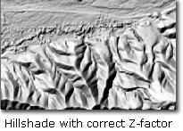
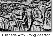
The Z-Factor parameter is in many Spatial Analyst and 3D Analyst tools; Hillshade and Slope are the two that I use most. Not setting the Z-Factor correctly makes the hillshades look heavy or leaden. It will also make slope values, e.g., for percent slope very small, like 0.00023% – 0.00032% instead of 1.8% to 7.2%.
When we download digital elevation models (DEMs) in raster format, the spatial reference is usually a geographic coordinate system (versus a projected coordinate system). Using these DEMS to create a hillshade using the Hillshade tool with the default values often produces a result that looks molten or over-done. This happens because linear units are not and cannot be defined for geographic coordinate systems.


Because the Hillshade Tool needs linear units to perform the function, it assumes that the linear unit of measurement (X,Y) is the same as the height unit of measurement (Z). The problem occurs when the linear units for the geographic coordinate system are different than the Z units for the DEM, like decimal degrees (which will vary across the extent of the data set depending on latitude), with a Z unit in meters or feet.
There are two ways to avoid this problem: 1) project the DEM using the Project Raster tool so that the linear units are defined (the linear unit is an inherent property of projected coordinate systems), or 2) use the optional Z-Factor parameter in the Hillshade tool (which multiplies the decimal degree value by the conversion factor to produce a measurement feet or meters, depending on the value you use). In terms of best practices, for medium and large scale maps we recommend projecting the DEM before producing a hillshade or doing any analysis. The only reason we can think of not to project a DEM or any data products produced from the DEM is when these will be part of a web service where the client of the service can choose a projection for the data themselves (projecting and then re-projecting a raster can result in unwanted loss of information).
If it is necessary to retain the DEM in a geographic coordinate system, knowing the appropriate values for the optional Z-Factor parameter is essential. The exact values will vary depending on the latitude of your dataset, here are some values to start with:
While there is variation in latitude within the extent of the data set (from the northern to southern edges), it is usually OK to use a single value in the approximate center of your dataset. Also, it is usually OK to use an approximate value since the visual differences in using similar numbers are so minimal. If you need to calculate a more exact value, simply determine the length of one degree at the latitude being mapped.
| Latitude | Z factor (in meters) | Z factor (in feet) | |
| 0 | 0.00000898 | 0.00000273 | |
| 10 | 0.00000912 | 0.00000278 | |
| 20 | 0.00000956 | 0.00000291 | |
| 30 | 0.00001036 | 0.00000316 | |
| 40 | 0.00001171 | 0.00000357 | |
| 50 | 0.00001395 | 0.00000425 | |
| 60 | 0.00001792 | 0.00000546 | |
| 70 | 0.00002619 | 0.00000798 | |
| 80 | 0.00005156 | 0.00001571 |
In addition to the Hillshade tool, there are many other tools in the Spatial Analyst and 3D Analyst that depend on proper use of the optional Z-Factor parameter when the data you are working with uses a spatial reference that is geographic coordinate system. You can use the same guidelines as above in these cases as well.
Note that you should also use the Z-Factor when the X,Y values are in feet and the Z units are in meters, or visa versa.

Commenting is not enabled for this article.