The ArcGIS Image Analyst extension for ArcGIS Pro 2.5 now features expanded deep learning capabilities, enhanced support for multidimensional data, enhanced motion imagery capabilities, and more.
Learn about new imagery and remote sensing-related features added in this release to improve your image visualization, exploitation, and analysis workflows.
Deep Learning
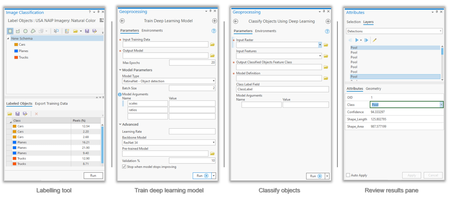
We’ve introduced several key deep learning features that offer a more comprehensive and user-friendly workflow:
- The Train Deep Learning Model geoprocessing tool trains deep learning models natively in ArcGIS Pro. Once you’ve installed relevant deep learning libraries (PyTorch, Fast.ai and Torchvision), this enables seamless, end-to-end workflows.
- The Classify Objects Using Deep Learning geoprocessing tool is an inferencing tool that assigns a class value to objects or features in an image. For instance, after a natural disaster, you can classify structures as damaged or undamaged.
- The new Label Objects For Deep Learning pane provides an efficient experience for managing and labelling training data. The pane also provides the option to export your deep learning data.
- A new user experience lets you interactively review deep learning results and edit classes as required.

Multidimensional Raster Management, Processing and Analysis
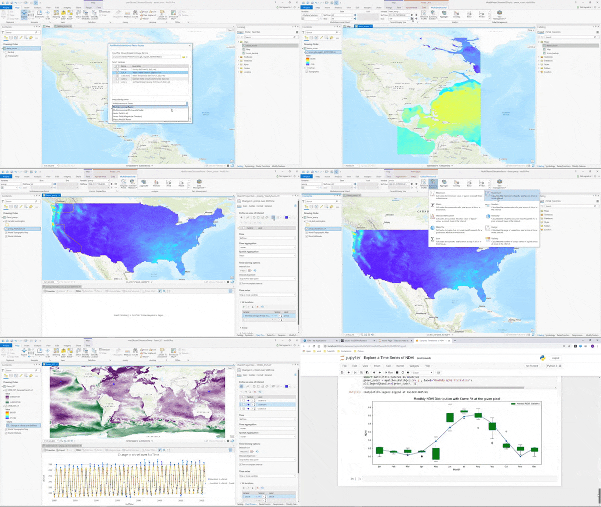
New tools and capabilities for multidimensional analysis allow you to extract and manage subsets of a multidimensional raster, calculate trends in your data, and perform predictive analysis.
New user experience
A new contextual tab in ArcGIS Pro makes it easier to work with multidimensional raster layers or multidimensional mosaic dataset layers in your map.

- You can Intuitively work with multiple variables and step through time and depth.
- You have direct access to the new functions and tools that are used to manage, analyze and visualize multidimensional data.
- You can chart multidimensional data using the temporal profile, which has been enhanced with spatial aggregation and charting trends.
New tools for management and analysis
The new multidimensional functions and geoprocessing tools are listed below.
New geoprocessing tools for management
We’ve added two new tools to help you extract data along specific variables, depths, time frames, and other dimensions:
- Subset Multidimensional Raster
- Make Multidimensional Raster layer
New geoprocessing tools for analysis
- Find Argument Statistics allows you to determine when or where a given statistic was reached in multidimensional raster dataset. For instance, you can identify when maximum precipitation occurred over a specific time period.
- Generate Trend Raster estimates the trend for each pixel along a dimension for one or more variables in a multidimensional raster. For example, you might use this to understanding how sea surface temperature has changed over time.
- Predict Using Trend Raster computes a forecasted multidimensional raster using the output trend raster from the Generate Trend Raster tool. This could help you predict the probability of a future El Nino event based on trends in historical sea surface temperature data.
Additionally, the following tools have improvements that support new analytical capabilities:
- The Aggregate Multidimensional Raster tool supports more aggregation keywords.
- The Generate Multidimensional Anomaly tool has four new options for the Anomaly Calculation Method
New raster functions for analysis
- Generate Trend
- Predict Using Trend
- Find Argument Statistics
- Linear Spectral Unmixing
- Process Raster Collection
New Python raster objects
Developers can take advantage of new classes and functions added to the Python raster object that allow you to work with multidimensional rasters
New classes include:
- ia.RasterCollection – The RasterCollection object allows a group of rasters to be sorted and filtered easily and prepares a collection for additional processing and analysis.
- ia.PixelBlock – The PixelBlock object defines a block of pixels within a raster to use for processing. It is used in conjunction with the PixelBlockCollection object to iterate through one or more large rasters for processing.
- ia.PixelBlockCollection – The PixelBlockCollection object is an iterator of all PixelBlock objects in a raster or a list of rasters. It can be used to perform customized raster processing on a block-by-block basis, when otherwise the processed rasters would be too large to load into memory.
New functions include:
- ia.Merge() – Creates a raster object by merging a list of rasters spatially or across dimensions.
- ia.Render (inRaster, rendering_rule={…}) – Creates a rendered raster object by applying symbology to the referenced raster dataset. This function is useful when displaying data in a Jupyter notebook.
- Raster functions for arcpy.ia – You can now use almost all of the raster functions to manage and analyze raster data using the arcpy API

Motion Imagery
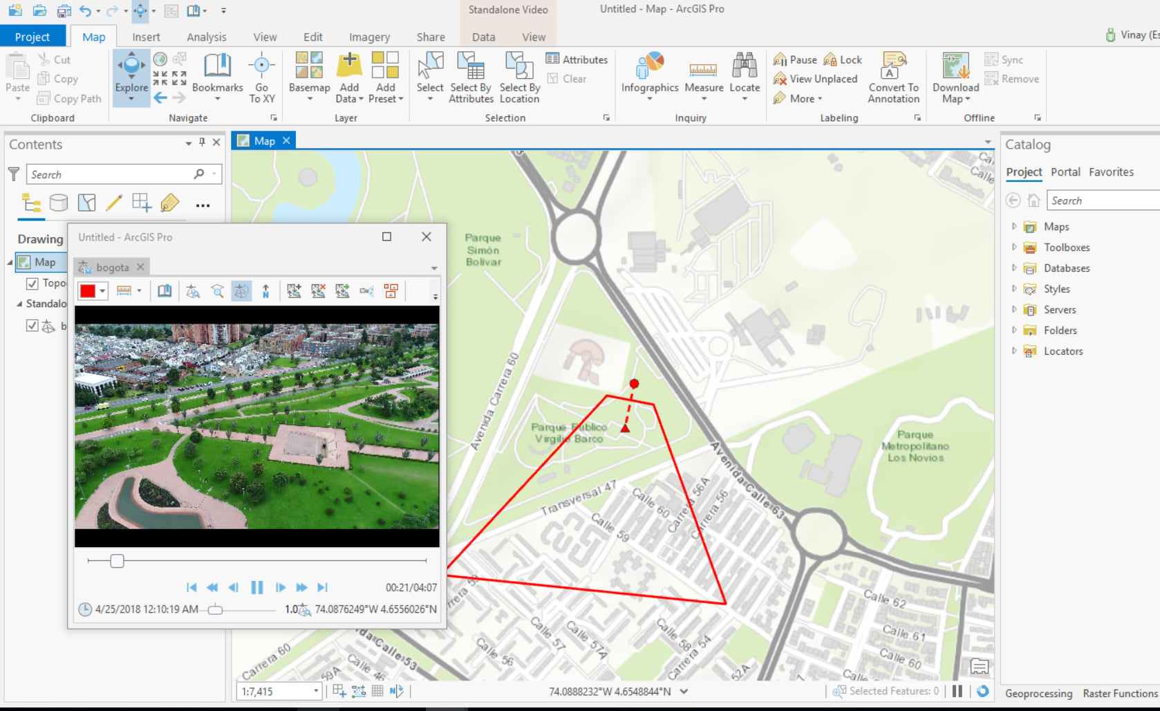
This release includes enhancements to our motion imagery support, so you can better manage and interactively use video with embedded geospatial metadata:
- You can now enhance videos in the video player using contrast, brightness, saturation, and gamma adjustments. You can also invert the color to help identify objects in the video.
- Video data in multiple video players can be synchronized for comparison and analysis.
- You can now measure objects in the video player, including length, area, and height.
- You can list and manage videos added to your project with the Video Feed Manager.

Pixel Editor
The Pixel Editor provides a suite of tools to interactively manipulate pixel values of raster and imagery data. Use the toolset for redaction, cloud and noise removal, or to reclassify categorical data. You can edit an individual pixel or a group of pixels at once. Apply editing operations to pixels in elevation datasets and multispectral imagery. Key enhancements in this release include the following:
- Apply a custom raster function template to regions within the image
- Interpolate elevation surfaces using values from the edges of a selected region
Additional resources
- Learn more about the ArcGIS Image Analyst extension for ArcGIS Pro and how to get it
- See what’s new in ArcGIS Pro 2.5
- Learn how to use ArcGIS Image Analyst, including hands-on tutorials
- Check out help documentation for ArcGIS Image Analyst

Commenting is not enabled for this article.