Summary
In today’s digital world, organizations are constantly seeking solutions to streamline processes and improve efficiency. Ecclesia, the largest German insurance broker for companies and institutions, partnered with con terra, a leading Geo IT-integrator, to develop an innovative application that transforms the property appraisal process. Leveraging the ArcGIS Maps SDK for JavaScript, Ecclesia and con terra have built a multi-layered platform with several digital applications that simplify and digitize the property appraisal process for insurance brokers. These applications empower non-specialized individuals to perform tasks previously handled by specialized staff, such as architects, driving high improvements in efficiency. They also enhance connectivity between assessment, risk evaluation, and insurance processes. As a result, Ecclesia has experienced cost savings through reduced site visits, accelerated claims processing, and improved productivity, leading to a more successful business.

Challenge: Complexities in Assessing Specialized Properties for Insurance Appraisal
The traditional process of property appraisal for insurance purposes presents several challenges, especially when it comes to hospitals, churches, and other specialized properties. Markus Wissing, an expert in the field, described the complexities involved by stating, “It’s a highly manual task because hospitals vary so much from one another. However, I see a tremendous opportunity to standardize and digitize these workflows.”
Accurately assessing the value of specialized properties poses distinct challenges due to their diverse structures, layouts, and specialized equipment. The assessments, conducted by architects who visit the site in-person, often fall short of capturing the intricate details of each property, leading to inaccuracies in insurance pricing. This lack of precision is further compounded by the lack of a consistent approach, making it difficult to streamline the appraisal process and integrate it into a digital workflow.
Another challenge is the lack of seamless collaboration and data access between customers requesting insurance quotes, brokers, underwriters, and risk engineers. The parties involved often rely on PDFs and emails to transfer and work with large amounts of data.
Recognizing these challenges, Ecclesia and con terra initiated efforts to develop a solution that automates the assessment process, ensures accurate valuations, minimizes media breaks, and establishes streamlined workflows.
Solution: Creative Applications with ArcGIS Maps SDK for JavaScript
Ecclesia and con terra collaborated on a two-year project to develop a multi-layer platform that automates property evaluations, conducts risk assessments, reduces physical site visits, and provides stakeholders with tools for collaboration and informed decision-making.
The platform is built on ArcGIS Enterprise, allowing seamless integration of multiple data sources and advanced geospatial functionalities. The ArcGIS Maps SDK for JavaScript also played a crucial role in enabling Ecclesia to incorporate interactive maps, spatial analysis, and data visualization into its property appraisal applications.

The JavaScript Maps SDK provided Ecclesia with the necessary APIs to import and visualize spatial data, enabling them to showcase all buildings in Germany within a single application. Leveraging the SDK’s high-performance 3D visualization capabilities, Ecclesia visualized over 56 million buildings in 3D from footprints and laser screening data. This accurate representation of each property’s physical layout and boundaries facilitates calculations of building size and dimensions crucial for determining property values and assessing potential risks, including structural weaknesses or damage.
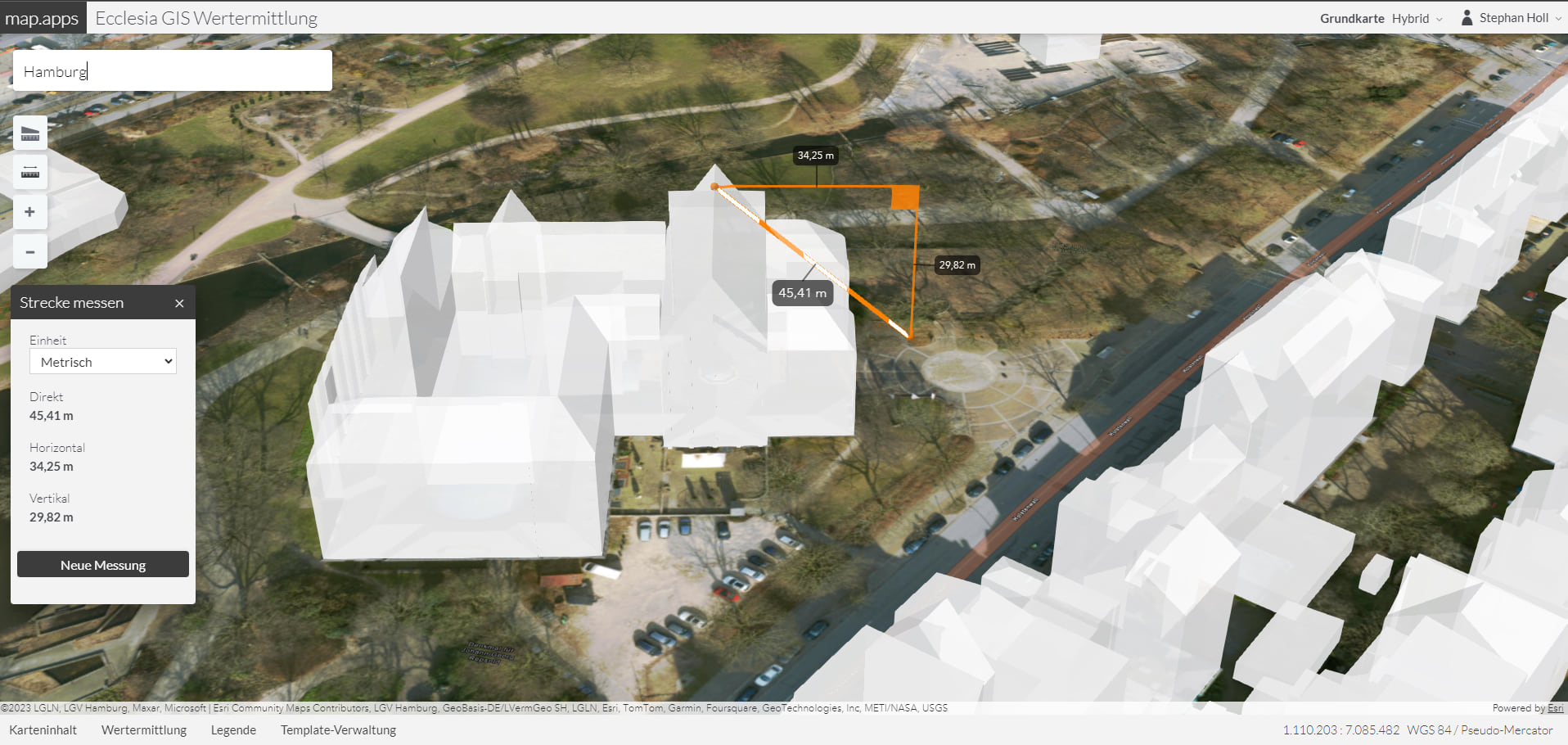
The integration of 3D models and routing technology further enhances the appraisal process, enabling detailed analysis of risks such as proximity to other buildings, fire spread potential, and evacuation routes for over 56 million buildings throughout Germany.
The Risk Assessment application uses risk factors, such as flood zones and fire hazard, to determine the risk associated with each building. Risk factors score layers are calculated by GIS (Geographic Information System) analysts and brought to the application as raster layers. Users can visualize the risk factors layers together with the 3D buildings for a quantified assessment. By evaluating the potential impact of flooding on property values and insurance coverage, Ecclesia can provide recommendations for flood risk mitigation and insurance options.

Finally, the applications are designed to provide answers and insights that even insurance brokers may not have been aware of previously. All the collected data, including building information, risk factors, and customer inputs, is cleaned and stored in multiple back-end databases, allowing smooth flow of information between stakeholders.
Overall, the platform built using ArcGIS Maps SDK for JavaScript empowered Ecclesia to conduct property valuations, perform risk assessments, and make informed decisions about insurance coverage and premiums.
Result: Improved Efficiency and Decision-Making Advancements at Ecclesia
The efficiency gains achieved through these applications are remarkable. The platform has empowered brokers to capture risks, complete appraisal processes, and assess risks, largely eliminating the need for on-site visits from architects. This allows architects to save time and take on other projects, driving efficiency gains for Ecclesia.
The platform also generates detailed reports that provide transparent information about buildings and their calculated values. This equips insurance companies to offer the best prices to their customers. The integration of 3D building data, aerial imagery, risk factor layers, and mapping functionalities provides a comprehensive view of properties for accurate assessments, mitigating the risk of under or over-insurance.

Additionally, the platform’s digital collaboration capabilities have enhanced coordination among stakeholders. Architects, risk engineers, and insurance brokers can seamlessly access and share information, facilitating faster and better decision-making.
Markus adds, “We have eliminated the bottleneck that relied solely on five architects and their limited information. The need for physical measurements using old-school tools is now minimized. Instead, stakeholders only need to visit specific places, while the remaining seventy percent of the assessment can be handled by regular Ecclesia brokers using the streamlined process.”
In conclusion, the Ecclesia and con terra platform, leveraging Esri’s ArcGIS technology, has revolutionized the property appraisal process. It empowers stakeholders with a user-friendly interface, impressive 3D visualization, comprehensive data integration, and efficient workflows. This has led to better decision-making, improved efficiency, and enhanced collaboration within the insurance industry.
The creation of our new application, utilizing the ArcGIS Maps SDK for JavaScript in partnership with con terra, has revolutionized our approach to property appraisals. The application has not only accelerated our decision-making process regarding insurance coverage and premiums but also allowed us to enhance our client service, enabling us to establish new benchmarks in the insurance sector.
Develop interactive web mapping applications with the ArcGIS Maps SDKs for JavaScript. Begin your journey by exploring our comprehensive Tutorials and Sample Code.


Article Discussion: