From hundreds of new and refreshed +Metro cities, to a massive broad area update of the United States, we have been very busy producing, curating, and publishing content for World Imagery.
DigitalGlobe Basemap +Vivid
+Vivid is our primary imagery basemap solution for providing high quality, high resolution, broad area global imagery. We have introduced new coverage for areas that previously lacked high resolution imagery, and we continue to refresh existing coverage.
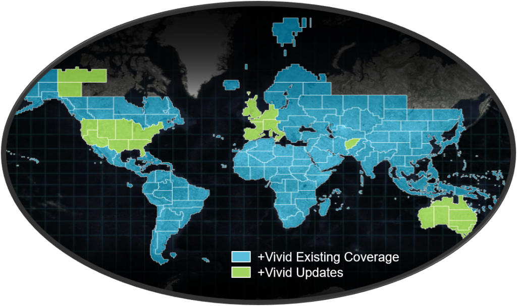
Recent and pending +Vivid Updates include: Afghanistan, Australia, Canada North West Territories and Yukon, United Kingdom, United States, and coming soon…a refresh of Western Europe.
The release of +Vivid across the United States is a significant step forward in terms of optimizing the overall depth, breadth, and currency of World Imagery coverage…
- Improved Currency. As we had already done for Western Europe, we have now replaced the existing Bing Aerial imagery across the US. The Bing Aerial imagery was beyond the targeted currency of World Imagery (>5 years) and introducing +Vivid allowed us to bring the imagery to within 0-3 years of currency. However, because the Bing Aerial imagery still offers significant value to some of our users, it will continue to be available through our World Imagery (Clarity) basemap tile service.
- Improved detail – Large Scales. +Vivid for the CONUS provides a high level of detail (50cm resolution) with very good visual consistency which means that we can deliver greater consistency across the country and across zoom levels, from medium to large scales. Given these advantages, we have replaced most of NAIP in World Imagery. Still need access to NAIP? Not to worry, users can still access NAIP as an Imagery Layer through our NAIP Image Service.
- Improved detail – Medium Scales. Our user community has requested improved quality, detail, and currency at the mid-range scales of World Imagery. The introduction of +Vivid has provided some key visual improvements, including coastal regions, which will enable us to follow through with this request. More details to come on this early in 2018….
- Tradeoffs. While +Vivid generally provides significant improvements for World Imagery, and the source product is curated to remove most cloud coverage, clouds can occur in some locations. If a user should encounter clouds over a location of interest, the aforementioned World Imagery (Clarity) and NAIP Image Services are excellent options for alternate sources of imagery.
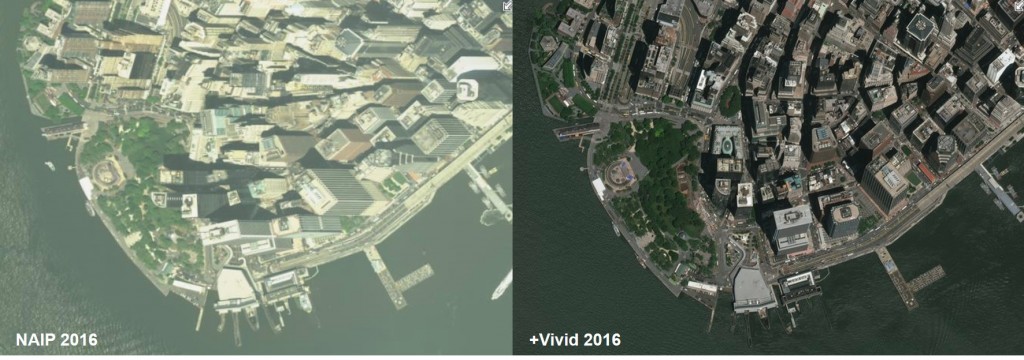
Sample comparison of NAIP 2016 vs +Vivid 2016 over Lower Manhattan…
DigitalGlobe Basemap +Metro
In our ongoing effort to ‘keep it fresh’, since October, World Imagery has received new imagery for 340 +Metro cities. That is more than half of our total +Metro city count! More than 300 of these cities are second generation publications…fresh imagery for cities that we just published within the previous year! Check out What’s New – DigitalGlobe Basemap +Metro for some highlights and a full listing of cities.
Community Maps Imagery
We continue to receive many high quality and high value contributions through our Community Maps Program. World Imagery has recently received many significant Community Maps contributions. Honorable mention goes out to the Florida DOT in the United States and a number of regional contributions across New Zealand…
Other recent community contributions…
- Hollister, CA
- Nashua, NH
- Yakima, WA
- Port Townsend, WA
- Minnehaha County, SD
- Sioux Falls, SD
- Berlin, Germany
- Hamburg, Germany
- Gaithersburg, MD
- Santa Rosa, CA
- Elgin County, Canada
- Salt Lake County, UT
- Squamish, Canada
- Dufferin County, Canada
- Cambridge, Canada
- Fargo, ND
We’ll close today’s post with best wishes and a very Happy New Year to our user community! Check back with us throughout 2018 for the latest in World Imagery updates!


Commenting is not enabled for this article.