Overview
ArcGIS GeoBIM delivers an innovative, easy-to-use web-based experience for teams to collaborate on building information modeling (BIM) projects and issues in geospatial context. Architecture, engineering, construction (AEC) and operations teams can make better decisions by securely accessing up-to-date project and asset information between ArcGIS and Autodesk Construction Cloud, including 3D digital models, documentation, issues, and reality capture.
Esri’s ArcGIS is an enterprise geospatial platform that provides a comprehensive set of capabilities for creating, managing, analyzing, and mapping geographic information. Together with Autodesk, Esri is committed to continually evolving connected GIS and BIM workflows between ArcGIS and Autodesk Construction Cloud.

Release Highlights
Simplified user administration and Autodesk folder selection
ArcGIS Enterprise 11.4 expands access to ArcGIS GeoBIM through the updated user types. This simplifies user administration by removing the need to manage add-on licenses. Users can now also specify the Autodesk project folders they need for ArcGIS GeoBIM workflows, resulting in faster processing and less clutter.
Want to help us drive new capabilities in ArcGIS GeoBIM? Share your ideas in the Esri Community.
ArcGIS GeoBIM included with user types in ArcGIS Enterprise 11.4
Projects often involve many stakeholders with varying access needs that may change over time depending on their roles and participation.
The updated ArcGIS user types now deliver access to ArcGIS GeoBIM through the Contributor, Mobile Worker, Creator, Professional, and Professional Plus user types. This simplifies how System Administrators and AEC Project Managers manage access for project team members and stakeholders.
Current Esri customers using ArcGIS GeoBIM on ArcGIS Enterprise 11.2 and 11.3 can benefit today. Esri has provided customers the ability to assign ArcGIS GeoBIM to users with Editor user types or above. Customers can log in to My Esri to see what licenses are available and assign them at their discretion.
To download ArcGIS GeoBIM on ArcGIS Enterprise for Microsoft Windows and Linux, visit My Esri and get started today.
Folder Selection
Specify relevant BIM project folders for ArcGIS GeoBIM workflows
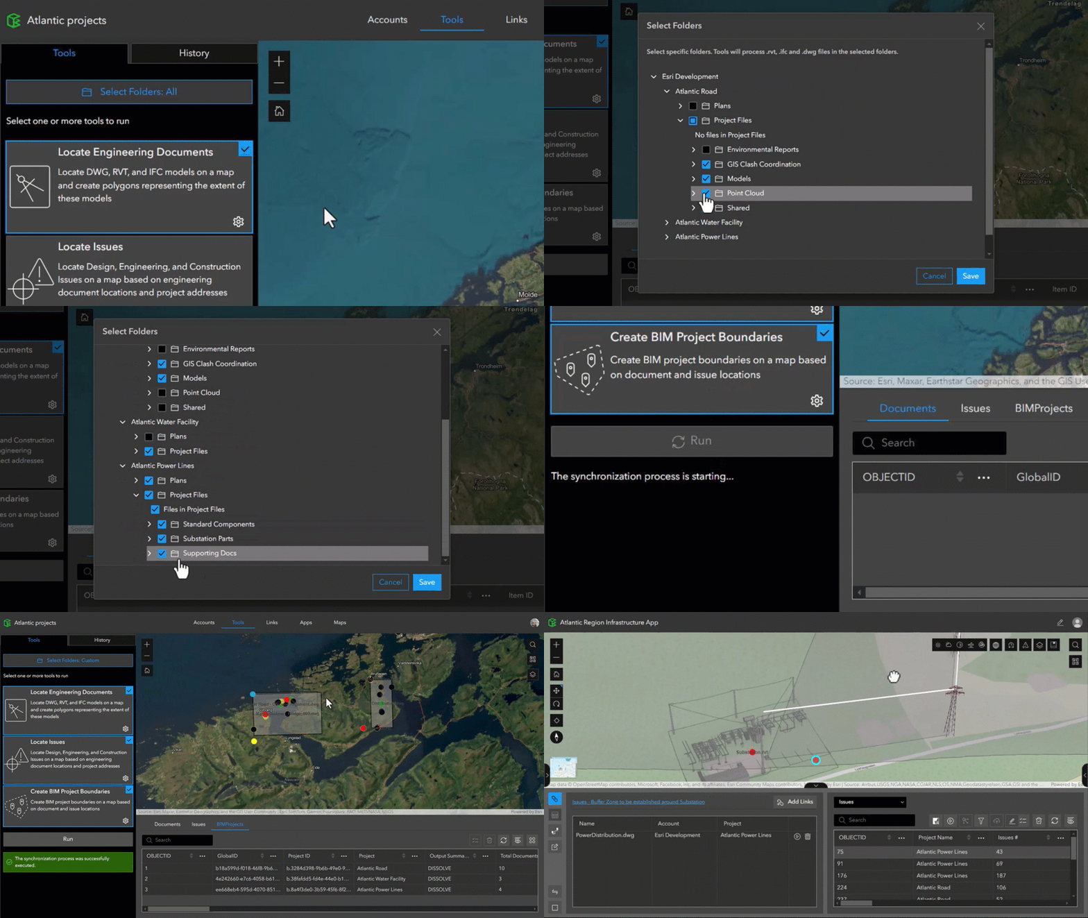
Cloud document repositories like Autodesk Construction Cloud can quickly fill up with data that may not be relevant for ArcGIS GeoBIM project workflows. With Folder Selection, users can easily choose BIM project data from a connected Autodesk account for even more control over the data they want to work with.
In the Tools pane, a new button and pop-up window let users select and deselect folders for adding to ArcGIS GeoBIM projects. Doing so results in faster processing and less clutter.

Discover more
ArcGIS GeoBIM proves critical for infrastructure megaproject
Discover how Rovella INMAC Consortium used ArcGIS GeoBIM to efficiently rebuild damaged infrastructure in Peru after a devastating El Niño event. Read how the AEC firm saved costs and improved decision-making on the project by linking GIS data with design and construction information in Autodesk Construction Cloud.
Enhancing Autodesk workflows with ArcGIS
For Autodesk users, Esri offers ArcGIS which is a suite of powerful tools that seamlessly blend geospatial data with design and construction processes. Discover the capabilities supporting civil engineers, CAD technicians, and project managers as we highlight how ArcGIS can enhance your projects and streamline your operations.
Share your feedback in Esri Community
Have a question for our GIS and BIM experts, or want to suggest ways to make ArcGIS GeoBIM even better? Post your questions, product feedback, and successes in Esri Community.
Access resources about ArcGIS GeoBIM
Learn how ArcGIS GeoBIM can enable GIS and BIM collaboration in your work by visiting this resources page for videos, tutorials, and more.
Get started with ArcGIS
New to Esri and ArcGIS? Get started with ArcGIS for BIM and CAD today.


Article Discussion: