Delivering infrastructure projects is complex and requires coordination across various teams with different expertise. Large-scale projects often intersect with environmentally sensitive areas, requiring a thorough analysis of potential impacts and compliance with environmental regulations. The environmental pre-construction phase can often be the most costly and the lengthiest phase of the project, responsible for a large number of delays.
By incorporating field data, teams gain a deeper understanding of the project site, including existing conditions and constraints that may impact designs, costs, and schedules. Geographic information system (GIS) technology enables the visualization, analysis, and management of spatial data—empowering project teams to identify sensitive or at-risk areas and design with potential environmental impacts in mind. Integrating GIS with building information modeling (BIM) in project delivery provides a collaborative approach to addressing environmental impacts, complying with regulations, and improving project outcomes.
This blog article explores a scenario where GIS and BIM come together with ArcGIS GeoBIM to streamline collaboration between engineers and environmental scientists for mitigating impacts on the delivery of a new underground rail project.

Planning construction in an environmentally sensitive area
In this scenario, a large infrastructure project is under way—the design and construction of a new underground rail line that is set to begin operations in 12 years. There are important features that would require review and mitigation, such as whether the project footprint crosses any waterbodies, streams, wetlands, and other environmentally sensitive features. During the desktop analysis, it is identified that part of the route will run beneath an environmentally sensitive area that is home to an urban forest with old trees that serves as a habitat for endangered bird and wildlife populations.
Many trees on the site are ideal habitats for bat maternity roosts, with hollows and large, healthy tree canopy—environmental features providing nesting and shelter for a wide range of wildlife that help to contribute to the overall forest health and biodiversity. Bats, in particular, are an integral species to the environment and provide pest control, pollination, and dispersing of seeds for habitat growth and biodiversity. Adhering to local tree canopy ordinances offers sustainability and environmental justice benefits by reducing long-term climate change impacts and improving quality of life for disproportionately affected communities.

The project’s engineers have designed an emergency exit building (EEB) to be located in the forest. However, they must ensure that the chosen location complies with regulatory requirements and minimizes environmental impacts. The environmental science team will help inform the design and optimal location of the EEB to minimize impacts on watercourses, vegetation, and wildlife by visiting the site. The project manager overseeing teams needs to keep the project within budget and on schedule, while also preventing future issues.
The engineers and environmental teams need a way to capture data in the field to locate the EEB optimally in the design model and mitigate environmental impacts.

Collaborating for project permitting approvals
The project team has been using Autodesk Construction Cloud as the common data environment (CDE) for collaborating on design and construction information, including BIM models and computer-aided design (CAD) drawings of the underground rail line infrastructure and assets. Projects at the architecture, engineering, construction (AEC) firm have deployed ArcGIS GeoBIM to connect the latest documentation from their CDE with GIS project data in ArcGIS—a complete enterprise geospatial system.
The engineering team has asked an environmental scientist to visit the site to verify initial survey data. They will need to confirm the trees most at risk for impacts, identify potentially affected water features, and inform the optimal placement of the EEB. With an ArcGIS GeoBIM project already created and connected to BIM documents in Autodesk Construction Cloud, the project manager enables ArcGIS Field Maps on the ArcGIS GeoBIM project for streamlining collaboration between the office and field. This lets on-site team members create issues and note observations from their mobile devices and easily access documents on a field map of the project site.

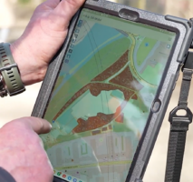
Before leaving for the project site, an environmental scientist reviews the latest design drawings in ArcGIS GeoBIM, as there may have been recent changes made by the engineering team. The environmental field scientist arrives on-site and uses the ArcGIS Field Maps mobile app to survey the radius of the proposed EEB location.
The environmental scientist observes that three of the closest trees to the emergency exit are beech trees and have hollows—two of which contain bat roosts. The field scientist creates an issue with each tree’s exact location, attaches photos with notes, and includes recommended buffer distances based on tree species and age.


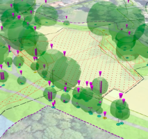
Using ArcGIS GeoBIM from the office, the project manager verifies the issues submitted from the field in real-time and makes minor edits for consistency. The issues with notes, recommendations, and photos are then uploaded to Autodesk Construction Cloud and attached to the precise locations within the associated BIM documents. The engineering team then views the issues with mitigation recommendations in the BIM model and they begin redesigning the emergency exit shaft with at least a 35 feet buffer from trees.
Due to the presence of an endangered bat species roosting in several trees on the project site, the environmental team has advised that construction at this location cannot start as originally planned. The Environmental Impact Assessment (EIA) will outline the specific time frames for bat maternity roosts, set up monitoring stations, and establish safeguards to protect watercourses and tree species. These actions aim to minimize construction impacts and comply with local and federal regulations.
As a result, the project manager will need to communicate these changes to the relevant teams and stakeholders and make necessary adjustments to the project schedule to gain permitting approval.
Connect GIS and BIM to improve project outcomes
Using GIS data collected from the field and incorporated into the BIM model, the engineering and environmental teams effectively collaborated, making impactful design adjustments, and minimizing environmental impacts on a portion of the project. By connecting GIS and BIM using ArcGIS GeoBIM and ArcGIS Field Maps, the project team was able to perform due diligence in compliance with regulations and adjust timelines accordingly.

Discover more
This office-to-field collaboration is not the only way your project can benefit from BIM and GIS working together. We are excited to bring together the powerful field workflows of ArcGIS Field Maps and the ArcGIS GeoBIM connection with Autodesk Construction Cloud to help you streamline your field operations.
- Learn how to collect issues from the field and share BIM documents with mobile workers in this blog article.
- Access resources and get started with ArcGIS GeoBIM by visiting the product page.
- Discover the latest ArcGIS Enterprise features and enhancements in the What’s New blog article.
Get started with ArcGIS
New to Esri and ArcGIS? Get started with ArcGIS for BIM and CAD today.


Article Discussion: