ArcGIS Field Maps is a powerful mobile app solution that streamlines field workflows for exploring maps, collecting and updating data, and sharing where mobile workers are and where they have gone, all within a single location-aware mobile app.
The June release is a MAJOR update to ArcGIS Field Maps and includes lots of exciting new capabilities including:
- Geofencing
- Utility Network support
- Indoor Positioning
- Capture GPS metadata for lines and polygons
- Additional contingent values capabilities
- Field Apps licensing changes
In addition to these updates, we’ve included strategic quality improvements to authentication, calculated expressions, and more. For a complete list, please reference our what’s new documentation topic.
Geofencing
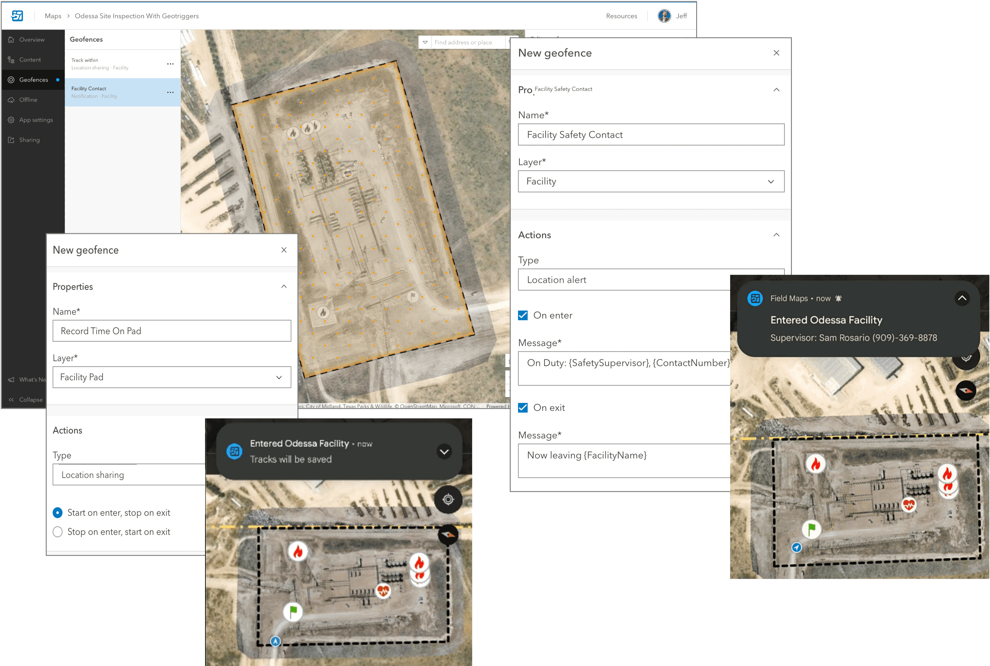
Field Maps now supports adding geofences to your maps so that mobile users can be warned when entering dangerous or restricted areas, provided critical information when approaching a building, tracked only when on company property, and more.
Geofencing is powered by the new ArcGIS Geotriggers capability. Geotriggers monitor user-defined conditions on a mobile device in real-time that result in actions on a mobile application. The actions are local to the mobile device.
Geofences can be added to any web map using the Field Maps web app. While the map is open in the Field Maps mobile app, actions will be triggered as the device enters or exits geofences. Geofences work in the foreground or background of the device and online or offline.
Field Maps supports two types of actions:
- Location alert – Location alert actions send location-based messages to the mobile user in the form of local notifications.
- Location sharing – Location sharing actions automatically start or stop recording locations based on the mobile user’s location. To use location tracking actions, location sharing must be enabled for your organization and your mobile users must have a location sharing license.
Geofencing capabilities are available with ArcGIS Online and ArcGIS Enterprise 11.1+.

Utility Networks
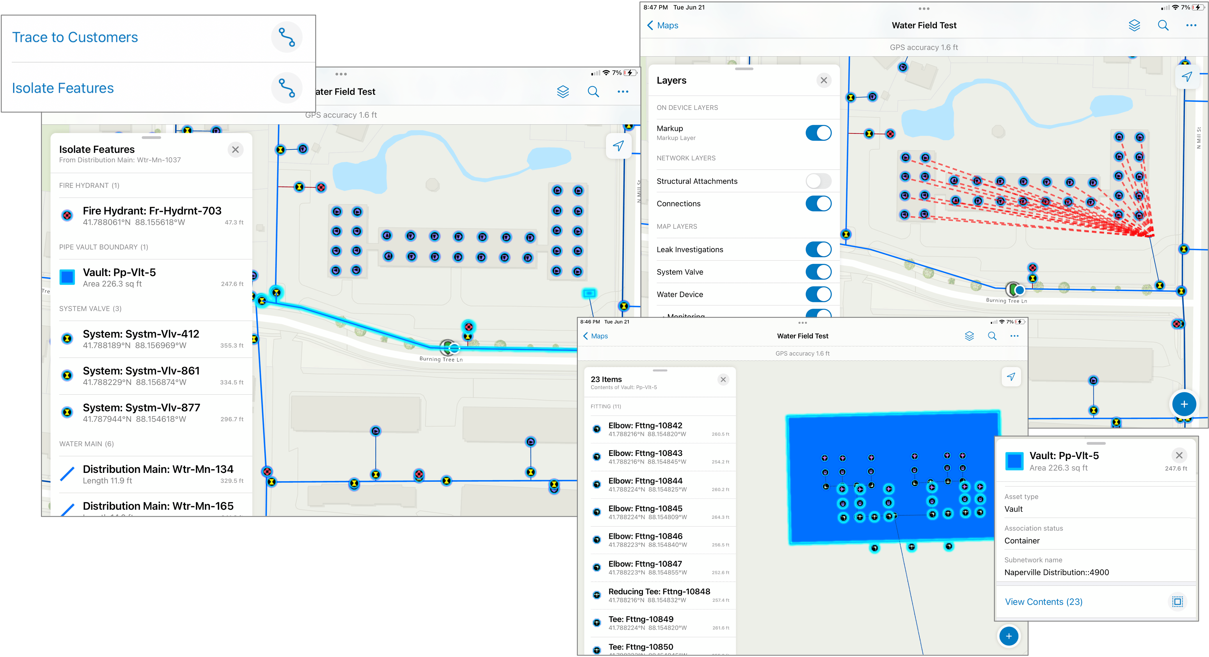
Utility networks provide a comprehensive framework of functionality for the modeling of utility systems such as electric, gas, water, storm water, and wastewater. It is designed to model all of the components that make up your system—such as wires, pipes, valves, zones, devices, and circuits—and allows you to build real-world behavior into the network features you model.
After you prepare, publish and share a utility network using ArcGIS Pro, you can open and use it in the Field Maps mobile app.
Capabilities of the utility network include:
- Viewing associations within the network, including connectivity, structural attachments, and containment.
- Tracing a network to return results based on the spatial layout and representation of equipment within the utility network
Caution: Editing utility network features is not recommended or supported at this time.
Utility Network viewing and tracing in ArcGIS Field Maps is available with ArcGIS Enterprise 10.9.1+.

Indoor Positioning
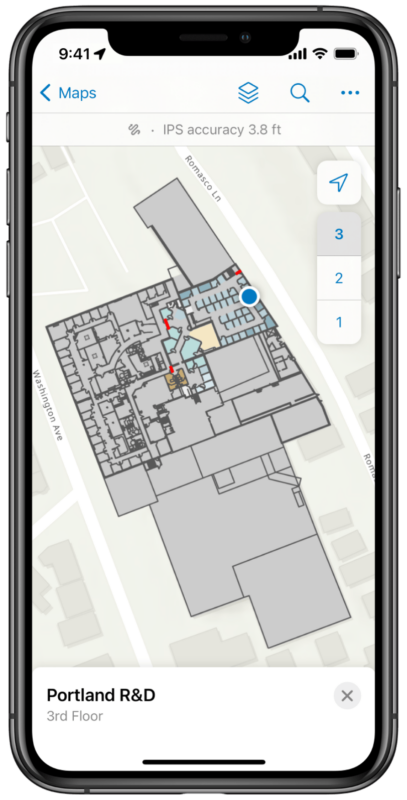
ArcGIS Field Maps works great indoors as well as outdoors. Last year we added support for floor-aware maps created and published using ArcGIS Pro or configure in ArcGIS Online.
Now we’ve integrated ArcGIS IPS within Field Maps to provide accurate geolocation so mobile users can locate themselves indoors. If you open a map in the Field Maps mobile app that’s configured for IPS, Field Maps will automatically detect IPS beacons within a building and use them to generate your location in the app. You’ll know when you have an IPS location fix as the banner above the map will display IPS accuracy instead of GPS accuracy. Tapping on the banner will provide additional IPS details like the position quality, number of transmitters, source type and floor.
Field Maps automatically determines the best location source to use—IPS or the device’s integrated GPS. If you move to a different floor in the building, the map automatically updates to display the floor you’re on.
Indoor positioning is supported with ArcGIS Online and ArcGIS Enterprise 11.0+.

Capture GPS metadata for lines and polygons
In addition to geographic coordinates, you can also save other GPS metadata associated with a feature, such as its accuracy and fix type. Storing this metadata can be valuable to assess data quality and ensure data collection standards have been met. If you include GPS metadata fields in your feature layer, Field Maps can write GPS metadata to the respective fields when editing features.
The following GPS metadata values are recorded by Field Maps when using a line or polygon layer:
- Worst horizontal accuracy (Field Name: esrignss_worst_h_rms, Type: Double)
- Average horizontal accuracy (Field Name: esrignss_avg_h_rms, Type: Double)
- Worst vertical accuracy (Field Name: esrignss_worst_v_rms, Type: Double)
- Average vertical accuracy (Field Name: esrignss_avg_h_rms, Type: Double)
- Worst fix type (Field Name: esrignss_worst_fixtype, Type: Small Integer)
Domain with the following code/label pairs (0/No Fix, 1/GPS, 2/Differential GPS, 4/RTK Fixed, 5/RTK Float) - Number of manual location (esrignss_manual_locations, Type: Integer)
ArcGIS Pro does not currently support adding line and polygon metadata fields. However, you can use the Add GPS Metadata fields notebook to update an existing line or polygon feature layer to support GPS metadata in ArcGIS Pro 2.5 or later. Please note that you need to enable attachments on the feature layer as well.
Authoring new GPS metadata capabilities are supported with Field Maps Designer in ArcGIS Online and ArcGIS Enterprise 11.0+.
Contingent Values
The May 2022 release of Field Maps introduces support for contingent values. Contingent values are commonly used to model natural classifications (trees, plants, wildlife) or material classifications for assets (poles, pipes) and can dramatically improve the efficiency and accuracy of form data capture in ArcGIS Field Maps.
With the June update, contingent values are supported offline. Also, we’ve dramatically improved the form authoring experience to better support field groups.
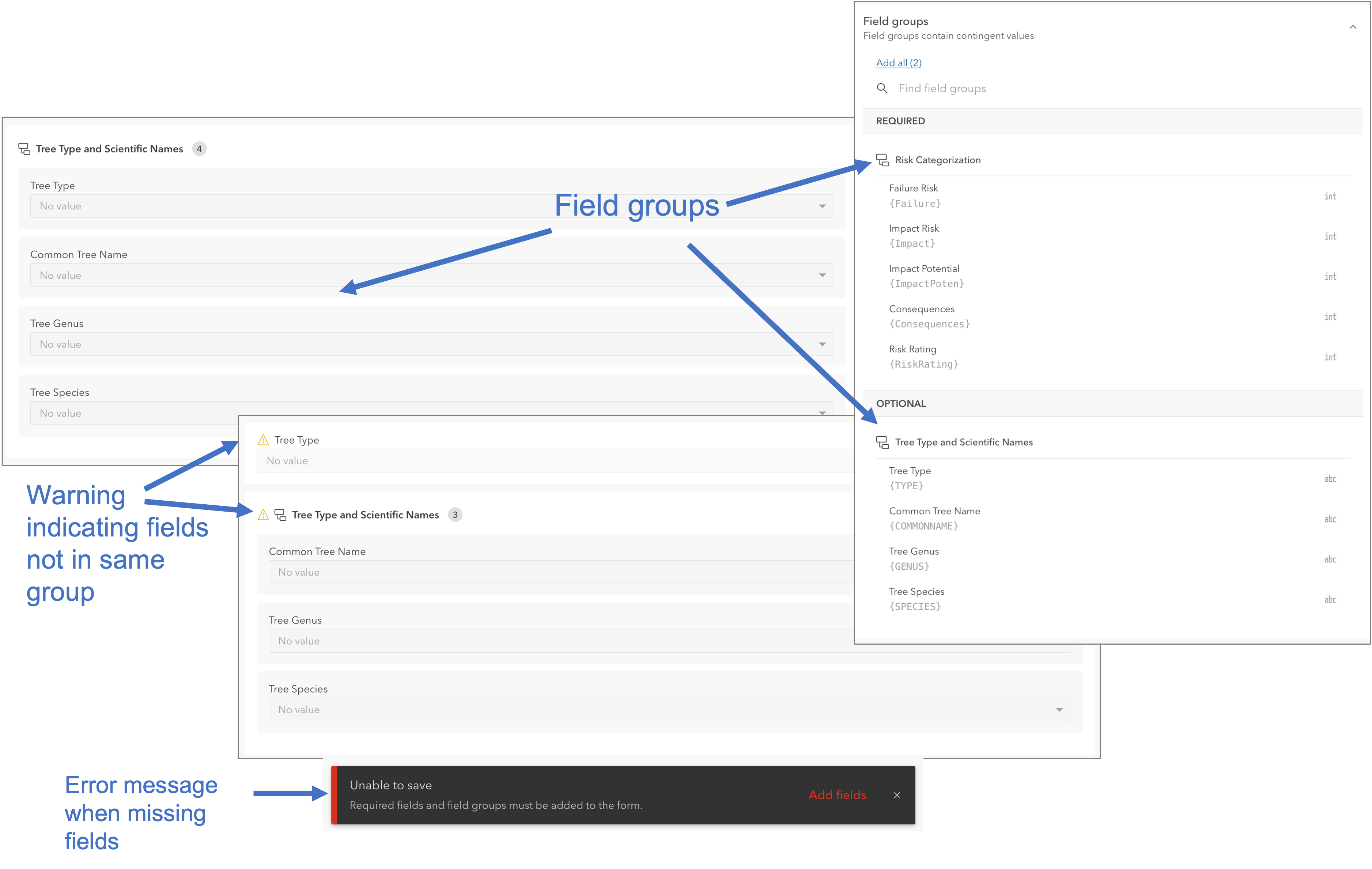
If contingent field groups were configured in ArcGIS Pro, they will appear in the Field groups list next to the form canvas. If field groups share common fields, they are listed together.
When a field group is added to the form, its contingent fields are contained in a group element. Contingent fields should stay grouped together so mobile workers can fill them out sequentially in the Field Maps mobile app. If a field is removed from its field group, a warning appears.
If field groups are required, they appear in the REQUIRED section of the list and must be added to the form. Field groups are required if they were configured as restrictive in ArcGIS Pro. If contingent field groups are not added to the form canvas, mobile workers may not be able to submit the form in the Field Maps mobile app.
Contingent values are available with ArcGIS Online and ArcGIS Enterprise 11.0+.

Field Apps licensing changes
With the June release of ArcGIS Online and the July release of ArcGIS Enterprise, we will introduce Field Apps licensing changes that impact ArcGIS Field Maps:
- Mobile Worker is the new name for the Field Worker User Type. There is no functional difference, and the Mobile Worker User Type will continue to be the tailored user type which lights up all of our field capability and applications.
- With the retirement of ArcGIS Tracker, we are retiring the ArcGIS Tracker App add on license as well. It has been replaced with a new Location Sharing User Type Extension. If you have procured an ArcGIS Tracker App add on license, you will have continued access until renewal. At this time you will need to assign a Location Sharing User Type extension to each named user that has a procured license.
What’s Next?
We’ve already started development on new features for our next release and will start early access programs later this summer.
Updates include:
- Get Started with the Field Maps web app by making your own maps and layers from scratch! Soon you’ll be able to create new maps and layers without having to use ArcGIS Pro or the ArcGIS Online home app. The Field Maps web app already includes the ability to add form elements and fields to existing feature layers, add reference layers to your map and even modify symbology and layer properties using the embedded map viewer.
- More Geofencing is coming with support for line and point layers as the source for geofences. We’ll also support filtering so alerts are only triggered from a subset of features within a layer.
- Layer Filtering is the top requested enhancement in Esri Community. Soon you’ll be able to dynamically filter text fields (with or without domains) in the Field Maps mobile app.
- Indoor Editing and Indoor Location Sharing are the two remaining development items to complete our support for indoor map use. Field Maps will fully complement ArcGIS Indoors as the premier map viewing, data collection, and location tracking app, optimized with floor awareness, indoor positioning, and indoor location sharing.
- Popups evolved when the new Map Viewer released. A new sub-property of popups were introduced to enable a richer experience for viewing in-line images, text, fields, and charts. These separate elements are not supported in Field Maps and that results in a fragmented solution when viewing maps and feature details between web and mobile applications.
These are just a handful of enhancements we are working on for the rest of this year. As development progresses we will start to provide early access opportunities so that you can keep pace with our development as it happens.
Soon we will be gathered in San Diego California for the 2o22 Esri Users Conference. Our team will be there and we want to meet everyone coming. Here is where you can find us! Please come say hi!

Article Discussion: