The March ArcGIS Online release includes demographic data updates for several countries. These updates are available through any apps that access Living Atlas maps or enable data enrichment, reports, and infographics. Read on to learn more about what’s new… or jump ahead to learn how these updates affect you.
United States & Puerto Rico
For the first time, we are releasing American Community Survey (ACS) data in March. In the past, these data were rolled out in the June release. The ACS 2014-2018 5-year estimates for the U.S. cover topics such as language, poverty, school enrollment, travel to work, rent, vehicles available, mortgage status, units in structure, year built, health insurance, and public assistance income. Learn more.
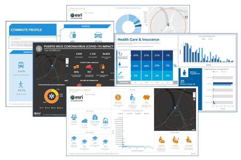
In addition, we’ve expanded the ACS data to include Puerto Rico. Categories include: Age, At Risk, Education, Health, Households, Housing, Income, Jobs, Marital Status, Population, Poverty, and Race. The data include a Reliability Flag to help you understand when an ACS estimate is safe to use as it relates to the margin of error. Read more about Understanding Margin of Error. You can access this data through ready-to-use infographics and reports:
- At Risk Population
- Commute Profile
- Coronavirus Impact Planning
- Demographic Summary
- Health Care and Insurance Statistics
- Key Population & Household Facts
- Housing Summary
- Population Summary

The release also includes updates to the following datasets for the US:
- Crime – 2019B release from AGS
- Traffic Counts – Q4 2019 from Kalibrate
- Business Locations – Jan 2020 from Infogroup
- Major Shopping Centers – Jan 2020 from Directory of Major Malls (DMM)
International Updates
Advanced Data for the Netherlands from 4orange
The 4orange data are updated from 2018 to 2019. Learn more.
International Data from Michael Bauer Research
The following countries were updated with new demographic data (from 2017 to 2019) from Michael Bauer Research GmBH:
Europe: Austria, Belgium, Denmark, Finland, France, Germany, Greece, Ireland, Italy, Liechtenstein, Luxembourg, Netherlands, Norway, Poland, Portugal, Russia, Spain, Sweden, Switzerland, Turkey, United Kingdom.
Data Retirement Announcements
From time to time, we review older datasets to determine when to remove them from service. Learn more.
Mature Status
The following datasets have recently moved to Mature Status. The data will be removed from service in a future release:
- Advanced Data for Australia from MapData Services
- Advanced Data for India from Indicus
- Advanced Data for South Korea from OPENmate
- Advanced Data for Puerto Rico from Census 2010
- Standard Data for Puerto Rico from Michael Bauer Research GmBH
Retired Status
The following datasets move to Retired Status in this release. The data will be removed from service in this release:
- Standard Data for Syria from Michael Bauer Research GmBH
How will these updates affect me?
For the Ready-to-Use Living Atlas Maps User within ArcGIS Online
Demographic layers and maps have been updated with the latest release of demographic data.
For the Business Analyst and Community Analyst Web App Users
Business Analyst and Community Analyst web app users can access the updated data through reports, infographics, and maps. The complete attribute list for each country is accessible through the data browser contained in the application. The default dataset in certain countries will change: Germany (to Nexiga), Spain (to AIS), Netherlands (to 4orange).
For the Data Enrichment User in ArcGIS Online and Other ArcGIS Apps
The March 2020 update provides access to the datasets shown above. For a detailed explanation of new or deleted attributes in datasets, see the relevant release notes in the documentation.
For the Developer using the REST endpoints of the GeoEnrichment Service
The underlying datasets of the REST endpoints of the GeoEnrichment Service were updated in March 2020. Some of the changes to the REST endpoints included in this release are:
- Changes to the layer IDs of the administrative/statistical boundaries.
- Changes to the layer names of the administrative/statistical boundaries.
- Changes to attributes/analysis variables including additions and deletions.
Because of updates to the underlying data, users of the GeoEnrichment Service may need to update these items in the query parameters of REST requests to the service from their apps. To view the updated REST endpoints, you will need to access the GeoEnrichment Service with a developer or organizational account, using a token request.


Article Discussion: