Esri offers a comprehensive set of ready-to-use demographic maps for over 170 countries and regions. Data categories include population, income, age, education, and consumer spending for a variety of products and services.
You can quickly access these maps through the Demographics and Lifestyle group in ArcGIS Online.
The group contains both pre-authored map layers that can be added to your own maps as well as finished maps (i.e. web maps) that can be used as-is or as the foundation for adding your own map notes and layers. The pre-authored maps are configurable and provide access to hundreds of measures about the demographics and lifestyles of people and consumers down to a local neighborhood level. These demographic maps are Premium items, indicating exclusive content for subscribers that consumes credits.
Starting today, the Demographics and Lifestyle group is the primary way to access these maps. As of November 27, these demographic maps will no longer be discoverable through ArcGIS Living Atlas of the World (livingatlas.arcgis.com).
Here are some common workflows and how to access the maps from the Demographics and Lifestyle group.
In ArcGIS Online
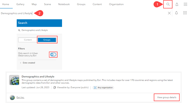
- From the ArcGIS Online home page, go to search
- Type ‘Demographics and Lifestyle’ in the Search Bar.
- In the resulting search window, select results in Groups. Toggle the filter option ‘Only search in [your organization] off.
- View the Demographics and Lifestyle group details and start browsing for content.

In Map Viewer
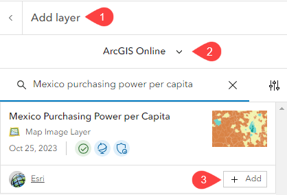
To add a map from the Demographics and Lifestyle group into your existing maps, Add Layer from ArcGIS Online, search, and add the desired map layer.

In ArcGIS for Microsoft 365
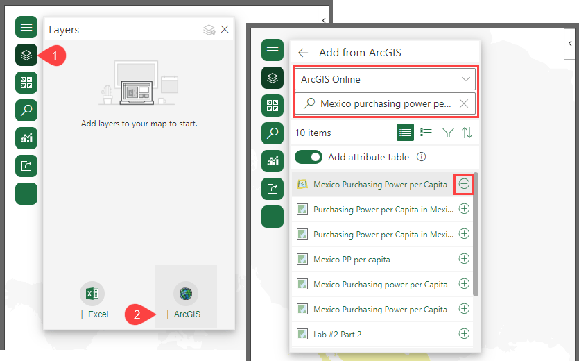
To add a map from the Demographics and Lifestyle group into your existing project, select the Layers button and add from ArcGIS. Note: you must be signed in to an ArcGIS account to see ArcGIS Online content.
In the dropdown window, select the option to search ArcGIS Online. Then in the search bar, search and add the desired map layer.

Get started by exploring the Demographics and Lifestyle group!

Can you please look into allowing the user to supply the bins or cluster shapes. We would rather it auto bin or cluster based on a polygon layer. We struggle to find any business use case for random bins really. But we need quick summaries by polygon all the time. It is a common issue I have struggled with for 15 years in Arc. The world runs on polygons from states, to districts, census blocks you name it, it almost always comes back to polygons. But there is no real easy way to do it. If you run a analysis… Read more »