We’re pleased to announce ArcGIS Runtime 100.10 is now available!
It’s been five months since our last release and 100.10, also known as Update 10, delivers some key enhancements that enable access to the new ArcGIS Platform, complete support for many online utility network workflows, enable access to high accuracy GNSS devices, add feature tiles and labeling in 3D, and improve offline use of styles and map tiles. Let’s take a closer look…
ArcGIS Platform
ArcGIS Platform is a Platform-as-a-Service (PaaS) that includes a new developer experience for accessing ArcGIS location services and content. Update 10 enables access to these services and content, such as web maps, web scenes, layers, and items, with an API key. An API key is a unique identifier used to provide authenticated access to a secured resource. An API key is similar to a token, but does not expire and can be used to monitor service usage from your apps.
A default API key is created for you when you sign up for an ArcGIS developer account. If you already have an ArcGIS account, you can use your dashboard to edit your default API key or to create new keys. You can also configure an API key to access specific services or content.
In addition, Update 10 introduces a new enumeration that references a new set of Esri basemaps available for use in a map or scene. These basemaps are secured and optimized for high performance. They can be accessed via an API key or a named user. When using an API key, you can monitor the usage of these basemap services from your apps.
Utility network
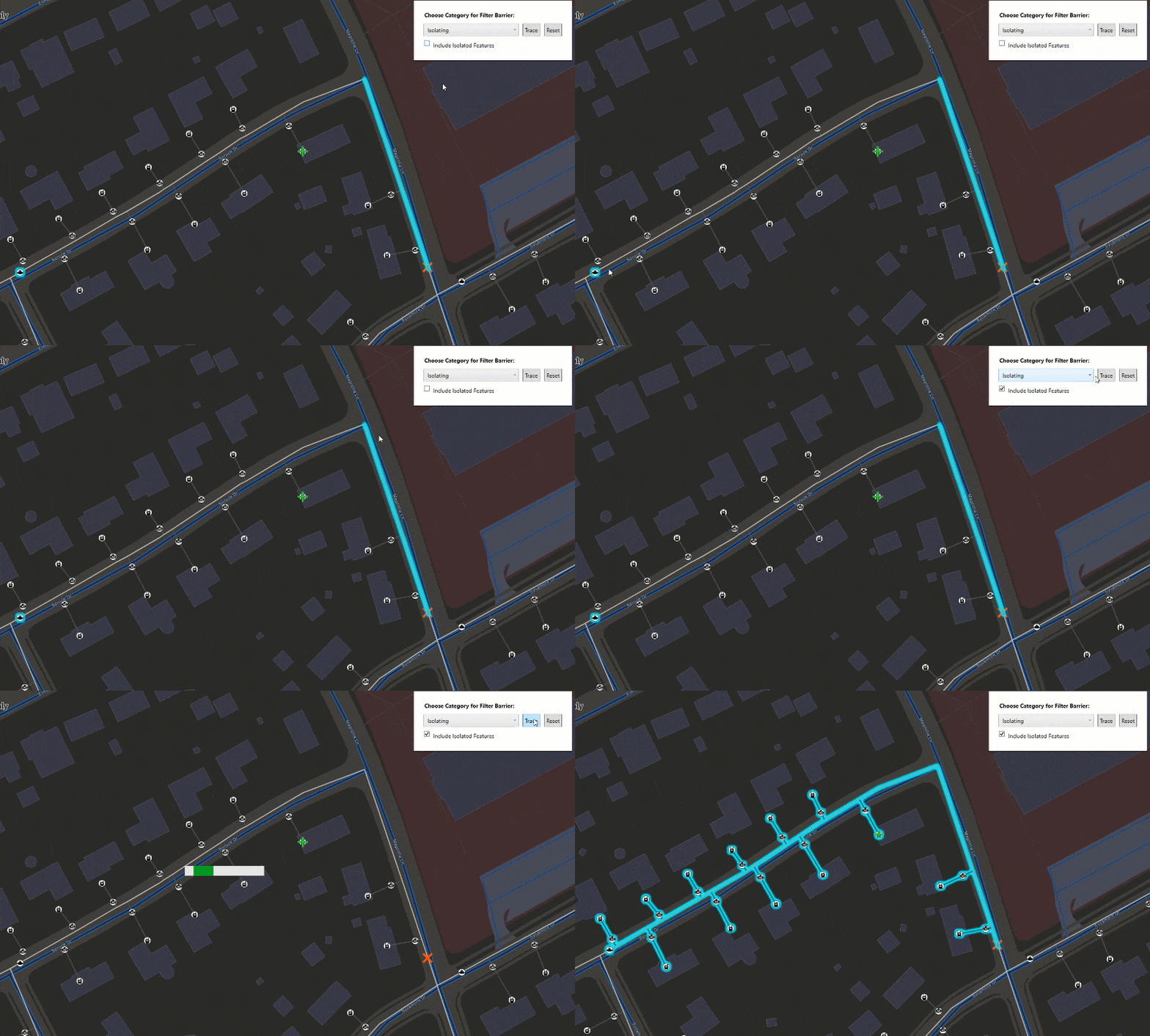
Over the last few releases we’ve nearly completed support for all trace types and configuration parameters. We already support the idea of using starting points and barriers in a trace. In general, barriers block traversability to the source. With Update 10 we add support for filter barriers which can stop trace results without stopping traversability to the source. This is important for modeling squeeze off points for gas pipelines. This addition basically completes our support for configuration parameters.

Support for utility networks is founded on our Web GIS pattern for delivering GIS capabilities. With Update 10, you can now read a web map that contains utility network information (when published with ArcGIS Pro 2.6 to ArcGIS Enterprise 10.8.1). The Runtime API provides access to a collection of utility networks stored with a web map and all utility networks in this collection can be saved in a web map.
A year ago a new schema version of the utility network was introduced, schema 4. This new version adds non-spatial object support for the telecom industry and underground network modeling for electrical utilities. We introduced support for non-spatial types in Update 9 and completed this work with non-spatial associations in Update 10.
Branch versioning
We first introduced support for branch versioning with sync enabled feature services with online/connected workflows in Update 9. Driven largely by needs in the utility space, we’ve enhanced Update 10 in 2 ways:
- We now provide an option to manage read/write sessions by limiting view and edit access to branch versioned feature services through two session types: persistent and transient. A service geodatabase (geodatabase that represents a feature service) in a persistent session will acquire a shared lock from the server which may be upgraded to an exclusive lock during an edit to allow multiple simultaneous viewers or a single editor. A service geodatabase in a transient session will not hold a lock in order to allow concurrent viewers and editors. Also, a new close method has been added to service geodatabase that will stop active viewing or editing by releasing any acquired locks.
- Developers can set the version of the feature tables participating in a utility network prior to performing a trace or a query – which enables evaluation of proposed changes to a utility network.
High accuracy GNSS
We enhanced our location API to support data sources from high accuracy GNSS devices so developers can more easily build solutions that take advantage of professional/survey grade location information. Technically we’re enabling access to GNSS sources to read/parse NMEA messages and use with Location Display in ArcGIS Runtime. Programmatically this capability is exposed as an NMEA location data source that provides access to an NMEA data stream which may come from a variety of sources – often a Bluetooth enabled peripheral device. An NMEA location object provides access to a host of location information including accuracy type, age differential, fix type, geoid separation, HDOP, PDOP, and VDOP, reference station, and number of satellites.
Symbology
About 6 months ago the web map added support for advanced symbols, which are defined by the Cartographic Information Model (CIM). ArcGIS Runtime already has the ability to read and render advanced symbols, but Update 10 adds the ability to read them from and save them to a web map, which means these symbols can be more easily shared across the system, from Pro, to web, to native. This is especially significant for industries that maintain an extensive set of sophisticated symbols, such as those in the defense sector.
We also have some exciting progress in support of web styles in Update 10. In general, styles are containers for distributing symbols. They can contain 2D or 3D symbols, or a dictionary where symbols are configured using multiple attributes. Styles published and shared as a portal item are web styles. With Update 10, ArcGIS Runtime has an API to access and use symbols in a web style directly. With Pro 2.7 a web map can be published with a dictionary renderer, and Runtime 100.10 will use it. If that dictionary renderer references a web style, Update 10 will read and honor it. If the web map that references a web style is taken offline, we’ll support taking the style offline with the map and it’s contents. Note, the offline option only works for 2D web styles and only though the offline map task at this point.
Offline
In addition to enabling the ability to take web styles offline, as mentioned in the previous section, other offline enhancements have focused on improving map and layer workflows:
- When a web map author creates a web map they can now define which layers which should stay online. We supported this in programmatic, on-demand workflows in Update 9. In Update 10, Runtime can now honor these web map settings for both on-demand and pre-planned workflows
- Export options within Runtime now support the ability to export raster tiles in the new version 2 tile format or tpkx. This will work with Esri basemaps backed by raster tiled map services and ArcGIS Enterprise 10.9 raster tiled map services.
- We now provide an easier way for developers to use export optimized ArcGIS Online vector tile basemaps when exporting vector tile packages. In general, these export-optimized vector tile basemaps contain a reduced font set (in general, Latin based languages only) which can reduce the size of the exported vtpk significantly.
Features
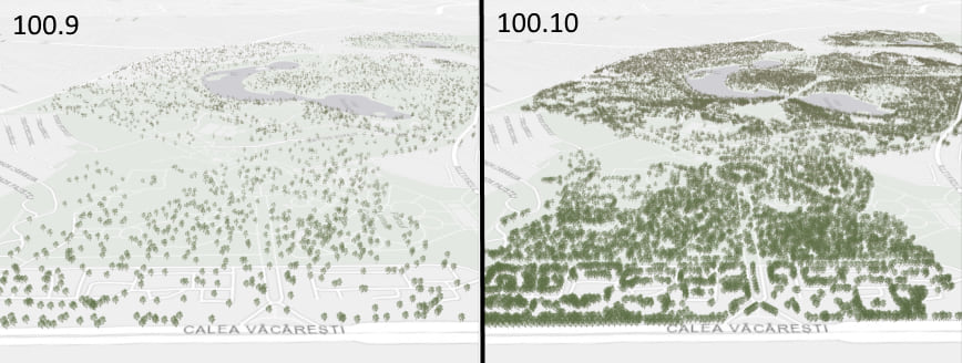
In Update 9 we released support for feature tiles in a map. In Update 10, we support feature tiles in a scene. We’ve also added an API to enable/disable use of feature tiling for developers that choose to do so.

With Update 10 you can now enable labeling in a scene the same way you do in a map. Labeling can be configured programmatically on feature layers or graphics overlays, honored as part of a feature service, or enabled for feature layers in a web scene or mobile scene package.
We introduced support for OGC API Features in Update 9 with basic functionality. In Update 10 we enhanced our support by adding the ability to define a spatial reference used by the server for reprojection, enable queries with time and custom CQL JSON, and support feature collections without a spatial column. In short, we continue to advance our support for parts 1 and 2 in the OGC API Features specification.
System improvements and updates
We have completed the ArcGIS Runtime licensing story for named users by adding support for StreetMap Premium extensions. In short, you can now purchase StreetMap Premium for Runtime add-on licenses for named users to license use of StreetMap Premium data with a Runtime app. Prior to Update 10, access to StreetMap Premium data required a license key, purchased via a deployment pack.
New locators were introduced with ArcGIS Pro 2.3 via the Create Locator tool and supported as of ArcGIS Runtime 100.5. These locators consist of a *.loc and *.loz file – they’re smaller, faster, easier to maintain, and offer consistency across the ArcGIS system. For Runtime developers that use classic locators (only *.loc) which are created in ArcGIS Pro via the Create Address Locator tool, we’ve extended their deprecation period. ArcGIS Runtime 100.11, due to be released in April 2021, will be the last release to support classic geocode locators. Note, this only pertains to use of local locators – there is no change to Runtime support for ArcGIS geocode services.
For Runtime developers that use ArcGIS Runtime Local Server, version 100.10 requires packages to be created with ArcGIS Pro. ArcGIS Desktop 10.x packages (created in ArcMap) are no longer supported. ArcGIS Runtime Local Server 100.10 is scheduled to be released next month.
In addition to the list above, we’ve introduced other enhancements, continued to fix issues, improve performance, and enrich our integration within the ArcGIS system. For more details on a specific ArcGIS Runtime SDK, see the release notes for Android, iOS, Qt, .NET, and Java.
Download and get started
To get 100.10, go to the ArcGIS for Developers web site, browse the ArcGIS Runtime SDK page of your choice and download the SDK. You can also reference through NuGet, Gradle, or CocoaPods. If you’re new to developing with ArcGIS Runtime and don’t have an ArcGIS Developer subscription, simply sign up for a free account and you’ll be able to access everything you need to develop your app.
Note: 3D building data displayed in banner image provided by Geodaten der Landeshauptstadt Dresden


Commenting is not enabled for this article.