There are so many new oriented imagery features this month! The oriented imagery capability of ArcGIS empowers you to turn all kinds of images into geospatial assets in your GIS: 360 images, street-level images, cell phone images, high oblique drone images, and more. Discover and explore full-resolution images in an intuitive viewing experience that combines multiple image perspectives with 3D, vector, and other geospatial data to improve human interpretation and generate new and unique insights from your GIS.
New in ArcGIS Pro 3.4—
- Visualize 360-degree and panoramic images
- Use deep learning to detect objects in oriented imagery layers and project them onto a map
- Take advantage of an improved Add Images to Oriented Imagery Dataset geoprocessing tool
- And more!
New in ArcGIS Online (November)—
- Project feature layers directly onto your imagery in the oriented imagery viewer
- Use Scene Viewer to publish a web scene with oriented imagery layers, then create a 3D oriented imagery web app with ArcGIS Instant Apps
Read on to learn more!
What’s new in ArcGIS Pro 3.4
Take advantage of new oriented imagery features in Pro 3.4!
Visualize 360-degree and panoramic images
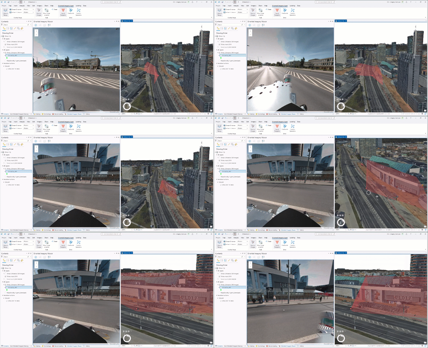
Expand the imagery modalities you can visualize in your desktop GIS to add insight and new perspectives, and improve your oriented imagery management workflow by visualizing your 360 and panoramic images in Pro before you publish your oriented imagery layer.
The 3.4 release of ArcGIS Pro supports equirectangular 360 images stored as JPEGs (the most common format). In future releases, we’ll expand 360 support to include stitched and unstitched cube maps, and to include tiled file formats like TIFF, COG, and MRF.
Use AI to detect objects in an oriented imagery layer
The Detect Objects Using Deep Learning geoprocessing tool now supports oriented imagery layers as input. The tool will detect objects in the images in image space, then use the oriented imagery image-to-ground logic to project the location of the objects onto the ground.
In this release, the tool will work best for features on the ground (like fire hydrants).
Enhancements to the Add Images to Oriented Imagery Dataset tool
Adding images to an oriented imagery dataset from cloud storage is now significantly faster thanks to the advantages of parallel processing.
Additionally, when you add images to an oriented imagery dataset, you can now use omega, phi, kappa to define orientation (the output orientation will be converted to heading, pitch, roll to align with the oriented imagery schema).
We’re also introducing new fields that users can use instead of the optional CameraOrientation field, allowing users to manage camera intrinsic parameters such as camera focal length, lens distortion and affine parameters as separate fields without creating a complex pipe-delimited string.
Both options are still supported—whether provided in the CameraOrientation field or using the new fields, these parameters support more accurate image-to-ground and ground-to-image transformations for better visualization. If the CameraOrientation field is present, those values will be used by default. Moving forward, though, we encourage users to use the new fields instead of the CameraOrientation field.
Check out documentation on the input oriented imagery table to learn more.
Leverage floor filters when you visualize an oriented imagery layer
For users working with oriented imagery in the context of a floor-aware map, explore your imagery more intuitively—the oriented imagery viewer now honors the level defined by the map floor filter when the floor level is defined for your images. If you’re looking at features on the 2nd floor in your map, now you be sure all your oriented images are on the 2nd floor, too.
Display the popup for the current image
The “Show pop-ups” tool in the oriented imagery viewer displays the pop-up for the current image, allowing you to view the image and its attributes at the same time to better understand the image you’re looking at.
Visualize MRFs stored locally in Pro
Previous releases of Pro could only visualize images stored as MRFs if they were in the cloud; now you can visualize these files in Pro when they’re stored locally, simplifying storage considerations and streamlining image management workflows.
What’s new in ArcGIS Online
Watch for new oriented imagery features in the November 2024 release of ArcGIS Online.
Overlay feature layers in the oriented imagery viewer
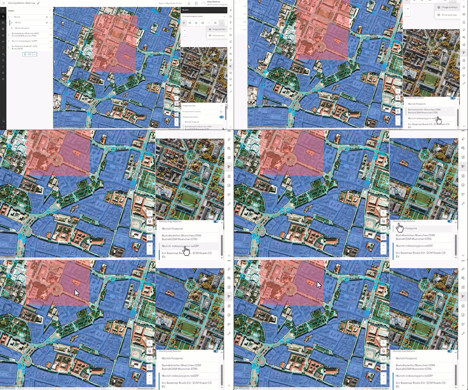
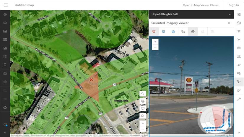
With feature overlays, you can now project feature layers directly into the oriented imagery viewer to better understand exactly how your vector data intersects with an image, adding context and understanding to both.
Support for overlays in the oriented imagery viewer is available in Map Viewer, the ArcGIS Instant Apps Sidebar and 3D Viewer templates, and in the oriented imagery widget in the ArcGIS Maps SDK for JavaScript.
You have the option to overlay feature layers from your web map or web scene, or you can overlay camera location points, which identify additional locations where images were taken that would be visible in the image. For overlayed feature layers, the symbology of the features in the oriented imagery viewer will be the same as the symbology used for the feature layer in the map or scene. Visibility of the features in the viewer is synced with their visibility settings on the map—if a feature layer is hidden on the map, it will not appear in the imagery viewer, and vice versa.
Use Scene Viewer to publish a web scene with oriented imagery layers
You can now use Scene Viewer to bring your 3D datasets and oriented imagery layers together in a published a web scene, providing the foundation for creating a 3D oriented imagery web app.
Add an oriented imagery layer to the scene, and you’ll see the oriented imagery layer’s camera locations points and coverage layer visualized in the web scene. If you have a Z-enabled oriented imagery layer, you’ll see the camera location points visualized in 3D space, providing valuable context about where your images were taken.
Scene Viewer doesn’t have the oriented imagery viewer (yet!), so you won’t be able to explore your imagery in Scene Viewer, but you will be able to use the published web scene to create a 3D oriented imagery web app.
Create a 3D oriented imagery web app with ArcGIS Instant Apps
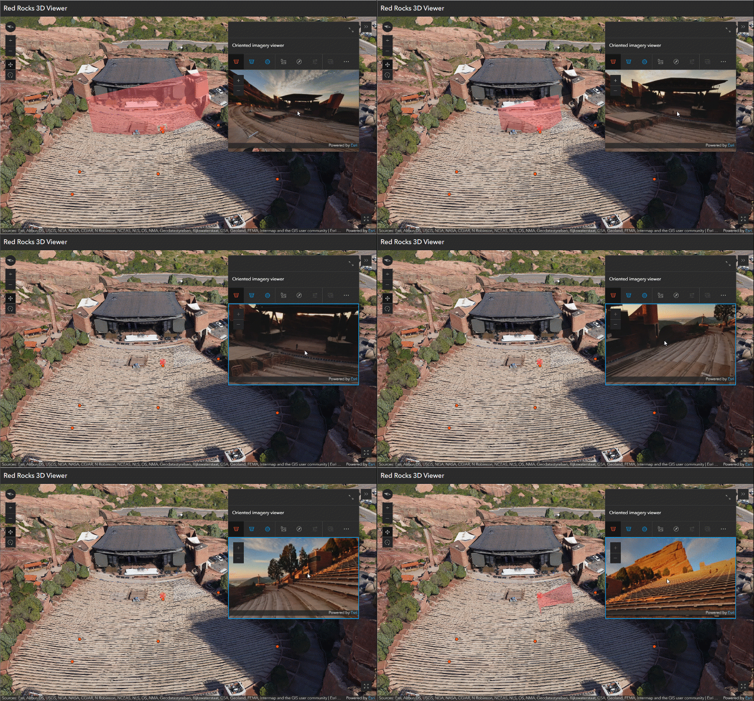
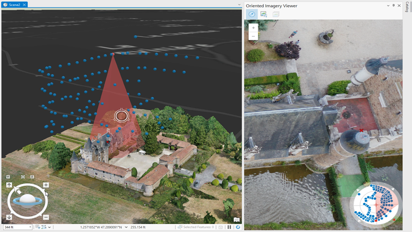
Use the 3D Viewer template to create and share a focused 3D oriented imagery web app, so you can quickly visualize imagery from an intuitive perspective in the context of 3D data (like integrated mesh or point clouds). Stakeholders can use the app to improve situational awareness, supplement inspection workflows, and better understand the spatial relationship between images and 3D layers.
Start by adding an oriented imagery layer and relevant 3D data to a web scene, then configure a web app using the 3D Viewer template with the oriented imagery viewer widget enabled. In the app, the user can click on the web scene to view an image of that location, see the 3D viewshed of the image dynamically update in the scene as you pan and zoom in the image, and explore other images of that location from different directions.
Enhanced footprints for 360 imagery
Footprints for 360 imagery are now more precise, with curved edges that better illustrate the camera’s field of view.
What’s new in ArcGIS Enterprise 11.4
ArcGIS Enterprise 11.4 will inherit the features that were introduced in June 2024 in ArcGIS Online. This includes a tool to display the popup for the current image in Map Viewer, and SceneView support in the ArcGIS Maps SDK for JavaScript version installed with Enterprise 11.4.
What’s next?
We’ve got exciting things planned for 2025, including an Experience Builder widget, the ability to digitize and measure directly in the oriented imagery viewer, and more, so stay tuned!
If you have oriented imagery-related questions, come ask us at Esri Community! And for Oriented Imagery Classic users, find more information in our updated Oriented Imagery FAQ.

Article Discussion: