In today’s world where data drives almost everything we do, being able to effectively manage and use imagery and remotely sensed data isn’t just a nice-to-have—it’s absolutely crucial. A solid strategy can seriously boost an organization’s ability to make smart decisions, ramp up operational efficiency, and spark innovation. That’s why Esri recently rolled out a webinar called “Managing Imagery and Remotely Sensed Data in the Enterprise,” and good news—it’s available as a recording so you can watch it now, even if you missed the live show.
This webinar is perfect for GIS pros, data analysts, policymakers, and business leaders knee-deep in data management who need a strong system to handle complex imagery datasets. It’s also super helpful for IT and data management teams eager to up their game in managing and analyzing big sets of imagery data.
ArcGIS: A Comprehensive GIS and Image Management System
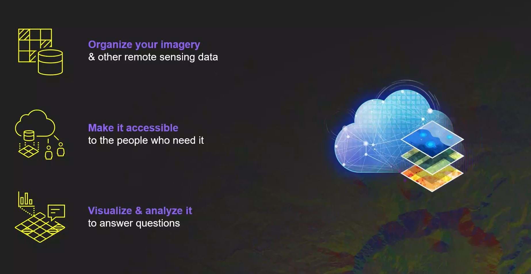
After watching this webinar, you’ll find out what many people have already found out—that ArcGIS is not just a tool in an enterprise toolbox. It’s a must-have data management system that will help you stay ahead of the curve. This system merges imagery and remotely sensed data with GIS data, turning these elements into actionable insights. Whether it’s crafting detailed site models, conducting thorough environmental monitoring, or boosting urban planning efforts, ArcGIS offers a comprehensive view that significantly sharpens decision-making.
The all-in-one ArcGIS system skillfully blends imagery and remotely sensed data with GIS capabilities. This integration doesn’t simply enable access to imagery. It makes it possible to create detailed environmental assessments and planning models by layering remotely sensed data – from imagery to Lidar to SAR and almost everything in between – over GIS layers.
ArcGIS can handle very large data sets from many sources. This means that your company can get the most complete and up-to-date information available. This helps your business run more efficiently and helps you make better decisions.
Extracting Maximum ROI from Imagery Data
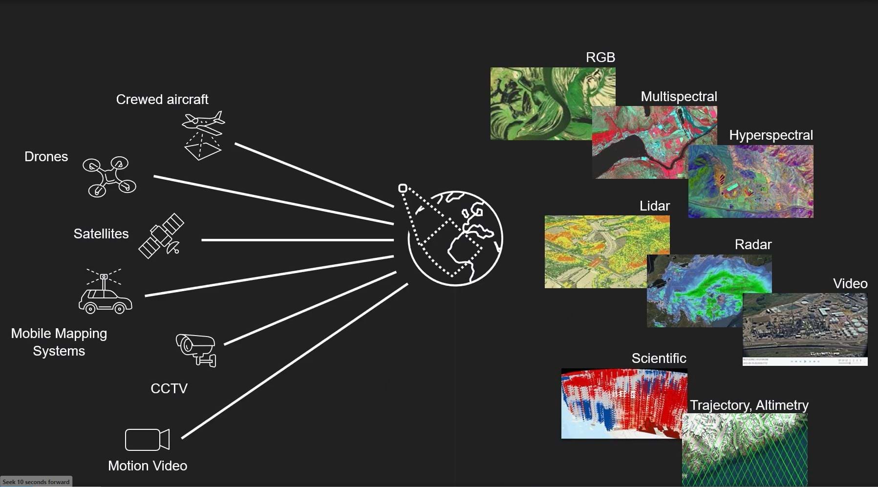
The webinar offers a closer look at how you can get the most ROI from various types of imagery data, whether it comes from drones, crewed aircraft, satellites … or even an iPad CCTV feed or traffic camera. Through real-life examples and map visualizations, you’ll see how ArcGIS can introduce new routes for analysis and applications (pun intended).
Why Watch the Webinar?
Imagery experts Dave Wright, Dave Peck, and Jonah Hall showcase the tools and features within ArcGIS that are key for managing imagery data. Their style is approachable, so image data management doesn’t have to be hard. You’ll hear them talk about how easy ArcGIS solutions are to use. It will show you how the system can handle a lot of data from different sources, and how you can make sure the right data gets to the right people at the right time.
This recorded session is not a show of what ArcGIS can do. It’s a look at how integrated imagery data management can help your organization move forward. By tuning in, Dave and Dave will help you discover:
- The strategic benefits of treating imagery as a vital enterprise asset.
- How tech integrations within ArcGIS boost data usability.
And be sure not to miss Jonah presenting success stories from ArcGIS customers who’ve used the imagery system to solve unique problems across many industries.
As we navigate an increasingly complex data world, managing imagery and remotely sensed data is becoming a key pillar of modern enterprise data strategies. Esri’s “Managing Imagery and Remotely Sensed Data in the Enterprise” webinar offers crucial insights and practical tips for anyone looking to boost their organization’s data capabilities. Watching this webinar could be your first step to changing your company’s whole data management plan. You can use ArcGIS to open new possibilities and make better decisions by using it.


Article Discussion: