With the oriented imagery capability of ArcGIS, expand the range of imagery sources and perspectives in your GIS to better inform decision-making and provide situational awareness.
Use the oriented imagery capability to seamlessly manage, visualize, and explore diverse image collections within the context of a map. Included in the October release of ArcGIS Online, ArcGIS Pro 3.2, and ArcGIS Enterprise 11.2, you’ll be able to incorporate a wider range of imagery types into your GIS, including high oblique drone images, close-range inspection images, street-level images, and images from mobile devices.

ArcGIS users have been leveraging the community supported, add-in version of oriented imagery (which will now be called Oriented Imagery Classic) for years. Now, Esri is integrating the same technology directly into the ArcGIS system.
If you’re a current Oriented Imagery Classic user, check out our Oriented Imagery FAQ for more information about migrating to the integrated oriented imagery capability.
This initial release will offer the foundation for the integrated oriented imagery capability in ArcGIS, but look for additional key capabilities (including support for 360-degree images, video, 3D scenes, and feature attachments) to be released in 2024.
The basics
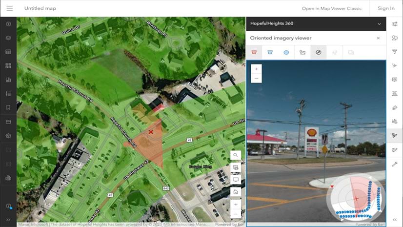
The oriented imagery capability offers a new way of relating images to the ground, which enables you to bring images that can’t easily be “mapped,” like street-level images or high oblique drone images, into your GIS. It uses information like the location and orientation of the camera, the camera’s horizontal and vertical fields of view, and a digital elevation model (DEM) that defines the ground to relate each pixel in an image to a location on a map (and vice versa).
This allows you to click on a map to view the best image of that location in the oriented imagery viewer, then see the image’s footprint dynamically update on the map as you pan and zoom in the image.

You can also use tools to explore your image collection:
- Find and view additional images of the same spot captured from different directions
- Explore thumbnails of all the images of the spot you selected
- Interactively identify where a specific image pixel falls on the map (and vice-versa)
- Adjust brightness, contrast, and sharpness to better see what’s in your image
The oriented imagery viewer and support for oriented imagery layers (used for managing oriented images) will be included in ArcGIS Pro 3.2; the ArcGIS Online edition of Map Viewer; and Map Viewer and ArcGIS Excalibur in ArcGIS Enterprise 11.2.
Why use the oriented imagery capability?
Add photographic context to your map, and add geographic context to your images. New types of imagery, like street-level images, add valuable visual context to vector data representing on-the-ground assets and areas of interest. Additionally, many organizations already have archives of nontraditional images, or you can easily acquire them. With oriented imagery, you can catalog, query, and visualize those images in the context of a map to find and interpret the images you need, and better understand their relationship to the other geospatial data you manage.
The potential applications are wide-ranging. Explore oriented images to provide situational awareness for first responders or field workers before they visit a site or asset. Use oriented imagery to manage and query an archive of images gathered over time—for example, when an issue like vegetation encroachment is reported, quickly review all the images of that location to confirm when it first occurred. Or, use oriented imagery to support inspection workflows by visualizing images of an asset from multiple directions.
A lightweight complement to ArcGIS Reality
Both the oriented imagery capability and ArcGIS Reality products generate accurate digital representations of the real world using images and geospatial data, also known as “reality mapping.” However, they serve different purposes, which can sometimes be used jointly.
With ArcGIS Reality, you can create authoritative 2D and 3D data products, such as True Orthos and 3D meshes, at virtually any scale. These products are generated from large collections of overlapping still images captured by drones, airplanes or satellites.
Sometimes you don’t need a True Ortho or 3D data products, or you already have them. Perhaps the images you have aren’t captured with the necessary overlap required to process them using ArcGIS Reality. Or, you need only a few images and want to view them in their full original resolution.
The oriented imagery capability provides the ability to manage, query, and visualize collections of individual images (overlapping or not), captured indoors, from the ground, or from the air, and visualize those individual images in geospatial context.
Used together, they can provide a detailed view of what’s happening on the ground, supporting inspection and providing you remote intelligence about areas or objects of interest so you can make informed decisions.
The oriented imagery workflow
Let’s take a quick tour of the end-to-end oriented imagery workflow. You’ll use ArcGIS Pro 3.2 to manage your images, optionally share an oriented imagery layer to ArcGIS Online or ArcGIS Enterprise 11.2, then visualize your images using the oriented imagery viewer in Pro, Map Viewer, or ArcGIS Excalibur.
Manage your images
To use oriented imagery, you’ll get started in ArcGIS Pro. Manage a collection of images using an oriented imagery dataset in ArcGIS Pro, then visualize it on a map as an oriented imagery layer (with an optional footprint layer).
The oriented imagery layer is a type of point feature layer that records the location where an image was acquired, the path where the image is stored, and key metadata required to visualize the image in the oriented imagery viewer. The footprint layer provides a visual reference to show the areas on the map that are depicted in images.
In the initial release, your images will need to be stored in local storage (which can be visualized in Pro) or hosted in public cloud storage (visualized in Pro or Map Viewer). Future releases will support images hosted as feature attachments to the oriented imagery layer, among other options.
Visualize and share your images
You can click on the map to explore the layer using the oriented imagery viewer in ArcGIS Pro. If your images are hosted in the cloud, you can also share the oriented imagery layer to ArcGIS Online or ArcGIS Enterprise 11.2, then view the hosted layer in either Pro or Map Viewer.
To find oriented imagery layers in your ArcGIS Online organization’s Content, you can filter by item type (select Layers > Feature Layers > Oriented Imagery layers). Add the oriented imagery layer to a web map in Map Viewer, select the layer, then click on the map to visualize and explore images of that location using Map Viewer’s Oriented Imagery tool.
For developers, the October release of ArcGIS Maps SDK for JavaScript also includes support for oriented imagery layers and the oriented imagery viewer widget.
What’s coming in future releases
This initial release of the oriented imagery capability will include the foundational end-to-end workflow for managing and visualizing oriented imagery, but we’ve got lots more planned for 2024 and beyond.
With the October release of ArcGIS Online, ArcGIS Pro 3.2, and ArcGIS Enterprise 11.2, you’ll be able to manage and visualize standard frame images (like from a GoPro, cell phone, or many drone cameras)—stored locally or hosted in public cloud storage—in the context of a 2D map. For Enterprise 11.2 users, ArcGIS Excalibur will also introduce support for oriented imagery layers.
More imagery formats and hosting options
In 2024, we’ll expand support for additional imagery formats, like 360 images, panoramas, video, and 360 video. We’ll also be offering additional image hosting options, including the option to store your images as feature attachments in ArcGIS Online or host your images using ArcGIS Image Server.
Advanced tools to exploit your imagery
Watch for additional tools for visualizing and exploiting your imagery, including measurement, vector data overlaid directly in your images, and the ability to digitize features in the image, then view them on a map. We’ll also be adding support for 3D visualization in ArcGIS Pro and Scene Viewer, including the option to superimpose imagery directly into a 3D scene.
Support in ArcGIS QuickCapture and Experience Builder
We’ll also be adding support for the integrated version of oriented imagery to ArcGIS QuickCapture and Experience Builder.
Next steps
Want to try oriented imagery yourself? Once Pro 3.2 is released, watch for a blog “Getting Started with Oriented Imagery” to walk through the workflow with a sample dataset. In the next few days, we’ll also release a gallery of sample oriented imagery layers for you to take for a test drive in ArcGIS Online.
Still have questions? Check out our Oriented Imagery FAQ for a deeper dive into common questions, including guidance for users of Oriented Imagery Classic. You can also visit the Esri Community page for Oriented Imagery to discuss issues with fellow users.
Is there an oriented imagery enhancement you’d love to see in an upcoming release? Let us know in Oriented Imagery Ideas.

Article Discussion: